The last few months have been hectic, with a lot of proposal writing and other things flying around - and as I continue to redefine and revisit and look toward new types of approaches and ways to tackle problems in architecting geospatial solutions, I have been making an effort to poke around and look at alternatives. Some of the major drivers for alternatives are licensing costs - Oracle is certainly not cheap - and the others are technical, finding fast and easy ways to publish and interact with geospatial data, provide interoperability and consume it in a wider variety of clients, e.g. OGC Web Map Service, KML, GeoRSS and the like...
So of late, I have been digging deeper with a stack consisting of PostGIS, GeoServer and GeoWebCache - and I must say I am impressed with what I'm seeing so far: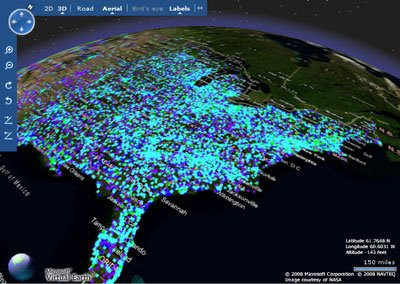
Here, hundreds of thousands of facilities points, being served up by PostGIS and GeoServer, and published as a tile layer in GeoWebCache. Firstly, the production ArcIMS/Oracle boxes I've been using would be struggling to render this much data quickly. Secondly, it would take a custom tile server or other middleware to get them into Virtual Earth - yet here I was able to get these results, start to finish, in less than an hour. Same data in Google Earth as KML, again GeoServer provides some very interesting and compelling out-of-the-box functionality...
Again, the question I have been asking myself is in what the solution needs to look like - and here, we can have some hybridized approaches, depending on how static or dynamic the data is, and how much analysis we want to do, perhaps with products like GeoWebCache and GeoServer serving base data and tiles, and ArcGIS Server 9.3 providing modeling and analytical capabilities. This coming year will be interesting, to say the least...


