Recently there have been a few articles about political unrest between the US and Canada over coastal waters, to include the Canadian military patrolling these waters with armed icebreakers.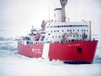
The main cause for concern is the reduction in surface area of multiyear ice along with a thinning of ice, which is working toward making the Northwest Passage across northern Canada a viable alternative for shipping. The Northwest Passage would present a route that is potentially up to 7,000 km shorter than using the Panama Canal. Canadian journal The Tyee has an interesting article that spells out and clarifies some of the specific issues and concerns, mainly revolving around policing and operations, such as liability issues associated with an arctic shipping route- oil spills, along with concerns about overexploitation of arctic fisheries, and the potential for entry of illegal weapons, drugs, or movement of WMDs by rogue nations.
Additionally the Tyee article lays out some of the history and confusion over ownership, with many arguments to either side about territorial waters and what Canada may or may not have legal jurisdiction over.
Certainly some very valid and important issues, which I hope our US diplomats can come to terms with and in fact offer a means of working with them together on, as opposed to butting heads. Currently it's my understanding that quite a bit of the cross-continental truck traffic in the US actually makes its way across from Pacific port to Atlantic port without a US destination in between- yet another sign of the intense demand for Atlantic/Pacific logistics. I would expect that a monitoring solution would include satellite-based remote sensing and communications platforms...
Technorati tags:
arctic, business, Canada, diplomacy, earth observation, emergency response, environment, environmental protection, exploration, geo, Geography, geopolitics, global warming, history, mapping, navigation, news, opinion, policy, remote sensing, rescue, satellite, security, stewardship


0 Response for the " Global Warming reshaping the map "
Post a Comment