Surveying, Mapping and GIS

Exploring all aspects of mapping and geography, from field data collection, to mapping and analysis, to integration, applications development and enterprise architecture...

  • Geospatial Technology, End to End...

    Exploring all aspects of mapping and geography, from field data collection, to mapping and analysis, to integration, applications development, enterprise architecture and policy
Showing posts with label cartography. Show all posts

Mapping for Haiti Earthquake Response

Posted by Dave Smith On 1/18/2010 04:30:00 PM 2 comments


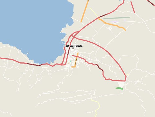
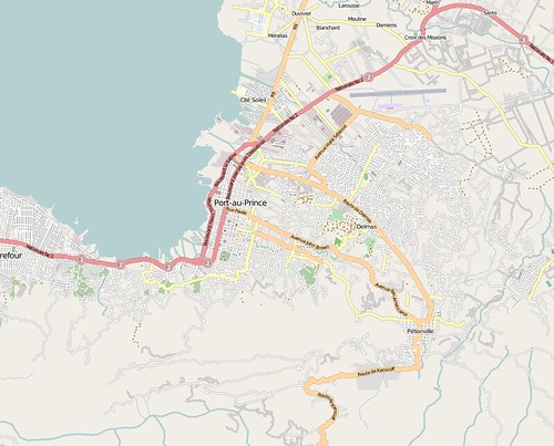
For the last few days I have been working on efforts to help Haiti earthquake response - part of this is mapping Haiti via OpenStreetMap. Currently, useful maps of Haiti are few and far between, in some case there are detailed maps for parts of the country and cities like Jacmel, but which are print maps (no digital edition exists), in many cases many decades old and outdated, in other instances the only maps which exist are small-scale, with limited detail. Commercial map platforms like Bing Maps, Google Maps and Yahoo vary greatly in their detail as well, and update cycles are slow - however, here, OpenStreetMap has been able to rapidly respond and provide very speedy and robust updates, to include capturing data about collapsed buildings, and so on.

Mikel Maron captures the speed and effectiveness of OpenStreetMap with these two screenshots of Port-Au-Prince, just before the earthquake and just after:

before:


after:


I would encourage any others who have time to contribute to get involved in this effort as well - editing can be done directly in OpenStreetMap via the 'edit' tab, which opens a web-based tool called Potlatch - or, a number of other tools are available as well. (You will need to register an account in order to edit - feel free to connect with me there as well - http://www.openstreetmap.org/user/Dave%20Smith). The OpenStreetMap WikiProject Haiti page provides a lot of good information and frequent updates. A number of data sources have been assembled, together with fresh post-earthquake imagery generously donated by companies like DigitalGlobe.

For folks who are interested in more robust tools, I primarily use Merkaartor which runs best on Windows platforms - others favor JOSM which is Java-based and runs on any platform supporting Java.

With either of these, you should be able to use the download function to navigate to an area of Haiti (select a relatively small area) and then download the OSM data

Some have wrestled with getting the various available imagery and map services to work properly in JOSM and Merkaartor - they are both a bit clunky about accessing WMS servers - I can offer some of my tips gleaned from a little debugging using Fiddler2: For Merkaartor, use Tools -> WMS Servers Editor and create a new entry with the following URL: http://maps.geography.uc.edu/cgi-bin/mapserv?map=/home/cgn/public_html/maps/mapfiles/haiti.map&version=1.1.0&SERVICE=WMS&REQUEST=GetMap? and show capabilities to access the DigitalGlobe CrisisEvent imagery (DG_crisis_event_service), select EPSG:4326 (only option available) and image/png and you should be able to go from there. If there is no image layer showing, go to Layers -> Add new image layer, and then right-click on the newly added image layer and select your newly-added WMS server for DigitalGlobe.

Digitization tasks are fairly intuitive - tools allow you to draw points, lines and polygons, as well as to create relations which allow multiple entities to be grouped together - however the absolute key to success is in proper use of tags to provide attribute values for any entities being created. These are generally intuitive as well, e.g. tag of highway, value of residential to turn a generic line into a residential road. It also helps to look at tagging of existing features, and to familiarize yourself with the features list - the OpenStreetMap wiki is searchable and quite useful. Finally, as terms of using the DigitalGlobe imagery, any data entered using their imagery should also be tagged with source=digitalglobe.

One of the other projects I have been working on is development of a set of tags that would be useful for emergency responders, relief and aid efforts - for this, I have started a wiki page http://wiki.openstreetmap.org/index.php?title=Humanitarian_OSM_Tags- any comments and thoughts can be added to the wiki page.

--- Update: Jan 20 ---

To update, I wanted to also include reference to the video tutorial that Kate Chapman put together on mapping for Haiti, to help demystify the tools:


Thanks to Kate and all the other great folks contributing to the Haiti mapping efforts...

Pennsylvania Surveyor's Conference 2008

Posted by Dave Smith On 1/20/2008 09:36:00 AM 0 comments

I am looking forward to going to the Pennsylvania Society of Land Surveyors' 2008 Conference. It kicks off tomorrow in Hershey, PA... There I will catch up with some of my old surveying colleagues and friends, as well as ping them on many of the other things that I've been dealing with, such as work on updating the NCEES Model Law via their Uniform Procedures and Legislative Guidelines Committee (UPLG) and Continuing Professional Competency for Land Surveyors as recently introduced via legislation in Pennsylvania - and potentially subject to an updated legislative effort, as well as many of the other things I work toward, such as data standards and geodesy, and many other plates spinning and hats I wear.
I am presently wrapping up a weekend spent with the UPLG Committee in Florida - which again raises some of the questions of defining practice, as regulated by law - with particular, sensitive crossover issues in Surveying being GIS and Photogrammetry, but also Engineering and other fields.

Treasured Maps of New York City

Posted by Dave Smith On 1/14/2008 12:41:00 PM 0 comments

The New York Post has an article today, titled "Treasured Maps" - highlighting the work of Scott Stringer, who is charged with preserving historic maps of New York City - among them, the Randel Farm map, which laid out the grid of Manhattan Island from Houston to 155th St.

These historic maps show many features of streams, wetlands, lakes and other things which have since been reshaped through development - a timeline of the good, bad, and the ugly contained in a map repository going back to 1748.

The world needs more Scott Stringers - he is steward for New York County's maps - I unfortunately hear periodically of plenty of other instances where maps lie crumbling, for lack of proper preservation.

Cadastral or not?

Posted by Dave Smith On 12/10/2007 11:23:00 AM 7 comments

After hearing some recent trials and tribulations of a surveyor arguing a legal lot line adjustment with the county GIS department (same story repeated again and again all across the nation), it again underscores the issue of what is or isn't cadastral GIS.

In Pennsylvania, our State Law says,

“Practice of Land Surveying” means the practice of that branch of the profession of engineering which involves the location, relocation, establishment, reestablishment or retracement of any property line or boundary of any parcel of land or any road right-ofway, easement or alignment; the use of principles of land surveying, determination of the position of any monument or reference point which marks a property line boundary, or corner setting, resetting or replacing any such monument or individual point including the writing of deed descriptions; procuring or offering to procure land surveying work for himself or others; managing or conducting as managers, proprietors or agent any place of business from which land surveying work is solicited, performed, or practiced; the performance of the foregoing acts and services being prohibited to persons who are not granted certificates of registration under this act as a professional land surveyor unless exempt under other provisions of this act.
As such, what exactly does a tax map represent? It seems that many GIS departments hop back and forth between boxes, either arguing that it is not surveying, and only deals with a schematic showing taxation, but at the same time, argue issues of deeds and possession, enter their parcel boundaries using COGO, and so on.

Either it is, or it isn't. If it is indeed a representation of the cadastre - and after all, taxation is uniquely tied back to the parcels and their possession - then it needs to be properly treated as such.

If, on the other hand, it's not a representation of the cadastre, then perhaps it's in fact something which perhaps has no real meaning, merit or legal standing whatsoever.

If the former is the case, then it likely needs to be getting developed and maintained under the purview of a licensed professional land surveyor, per state law - if the latter is the case, then I believe the whole process needs to be re-evaluated.

I'll put this out there for debate, with the caveat that I did intend to stir the pot - I'm interested in getting others' earnest perspectives.

Tabula Peutingeriana

Posted by Dave Smith On 12/04/2007 12:59:00 PM 1 comments

Along the historic maps vein, another ancient map receiving a lot of press of late is the Tabula Peutingeriana - this one I find tremendously fascinating, being a view of the Roman world of nearly 2000 years ago. As a kid, I grew up in Germany, near Roman ruins of the Limes Germanicus and other features, and as such, I have always been fascinated with all things ancient.

Presently, the Tabula Peutingeriana is being added to the UNESCO Memory of the World Register as an important artifact, and, given its extreme fragility, was recently placed on public display for one day in Vienna on November 26th.

The Tabula Peutingeriana is a copy of a Roman cursus publicus, which was a schematic roadmap of roads, cities and other features as developed and used in the Roman Empire. There are no longer any known copies of the original Roman cursus publicus charts, however the Tabula Peutingeriana is believed to have been transcribed from an original one by a thirteenth-century monk in Colmar, and consists of a number of sheets with schematic diagrams showing stops along routes, very similar to a modern-day subway map.


As such, it displaces many features to fit the route rather than attempting to be cartographically correct, and as such, it does not represent latitude and longitude in a conventional sense - instead accomodating the routes and features along them first and foremost, resulting in a very long, skinny map generally oriented west to east.

The geographic extent of the map is staggering, spanning the British Isles to India and Sri Lanka, showing what would have been trade and military routes, the infrastructure and cultural exchange that would have gone on in Roman times.

One of the things that I was playing around with over the weekend is trying to match up features as shown on the Tabula Peutingeriana to modern features - one of the tools I was playing around with is Microsoft Research's MapCruncher for Virtual Earth:

While I wouldn't expect MapCruncher to be able to rubbersheet a schematic map such as the Tabula Peutingeriana to a conventional map, it has nonetheless given me many insights just in being able to match up ancient designations and routes to their modern counterparts in a managed fashion, and it has made for a fun rainy (or snowy, as the case may be) day project.

Remaining Mysteries of the Waldseemüller Map

Posted by Dave Smith On 12/04/2007 12:37:00 PM 1 comments

Reuters is carrying a story about the preservation of the 1507 Martin Waldseemüller World map, the first known to refer to the New World as America.


Some of the individuals cited in the article express their puzzlement at how Waldseemüller was able to portray as much detail and accuracy as he did, given the extremely limited amound of knowledge that is generally believed to have been extant regarding the New World at this time - for example, Vasco Núñez De Balboa had not crossed the Isthmus of Panama to reach the Pacific until 1513, and likewise, Magellan had not rounded the southern tip of South America until 1520, yet these are shown.


Interestingly, many features in this map are reversed in subsequent maps by Waldseemüller.

The map is cited in the article as a 'keystone map', showing a fundamental shift in how Europe viewed the New World. It also raises many questions about how much we really understand geographic awareness and the availability of cartographic information in ancient times.

My own notion is that we sometimes do not give our predecessors enough credit for their knowledge of the world around them.

ESRI Plenary, yet more notes...

Posted by Dave Smith On 6/24/2007 10:32:00 AM 0 comments

ESRI International User Conference 2007

Plenary Session, 6/18/2007 - Continued

Here continues my posting of notes from the UC... Still enumerating new features for 9.3...

Multiple Views

Yes, the much-awaited multiple views for ArcGIS Desktop 9.3 are coming...

Labeling

9.3 brings enhanced label management, with a "pause labeling" feature, which skips labels in interim operations, and thereby allows faster redraws and navigation.

Polygon labeling offers new options as well - "label at fixed position within polygon", labeling of all polygons on a given layer at upper right, lower left, bottom center, and so on.

Contour labeling has been enhanced, to allow groups of contour labels to be linear, in holding with cartographic standards.

A "river labeling" style has been added, to better follow rivers.

P1010013

WYSIWYG Editing

ArcGIS 9.3 brings true What-You-See-Is-What-You-Get (WYSIWYG) editing of features and for cartographic representations. Currently, when a user drags an entity, it is shown in wireframe mode, but 9.3 dynamically shows what the actual feature will look like while being dragged.

Overlaps

9.3 has functionality that highlights overlaps, as well as a great new "disperse markers" feature, which allows overlapping markers to be automatically rearranged in a number of styles.

Cartographic Representations

For tips and tricks for enhanced cartographic standards and representations, and toward optimizing features and functionality in ArcGIS Desktop 9.3, ESRI has set up a "Mapping Center" website, located at http://mappingcenter.esri.com/.

Job Tracking Extension (JTX)

The new Job Tracking Extension offers interesting new functionalities for ArcGIS Desktop and Server 9.3. Essentially, it tracks and manages workflows.

(more to follow... trying to catch up with family first)

ESRI UC...

Posted by Dave Smith On 6/05/2007 09:24:00 PM 2 comments

Have not posted in some time, not that there's enough to talk about, but rather far too much - I frankly have been spending quite a bit of time on the road, between several trips to Research Triangle Park, NC, Washington DC, the EPA GIS Workgroup meeting in Boston, the NCEES Northeast Zone meeting in Newport, RI... have been home for a bare handful of days over the last month and a half, and any free minutes have been devoted to home and family, rather than the blog. A ton of interesting geospatial things going on, but unfortunately I can only talk about a few of them (though I hope to)...

And upcoming... finally sat down long enough to get my flight and hotel booked for the ESRI User Conference coming up in a couple of weeks. Looking forward to it... Arriving Sunday night, and am actually going to be in San Diego until Friday evening (!)... Would have preferred to leave Thurs night or Friday AM, but given availability of flights, it didn't work out - but this way I can do something for fun on Friday.

But hey! Looking forward to going to SD again this year!! Maybe I'll gin up a little "geoblogger" badge, so don't be afraid to say 'Hi' if you see me... I haven't yet even checked to see if there are any blogger meetups. I think there are several other extracurricular events planned as well, have a few invites but haven't yet even had a chance to sort them all out.

USEPA GIS Workgroup

Posted by Dave Smith On 4/22/2007 04:47:00 PM 0 comments

I am looking forward to attending the EPA GIS Workgroup meeting coming up in Boston. This time around, the spring meeting will be in Boston, at the Omni Parker House Hotel, May 15th to 18th.

It will be good to refresh some contacts and make some new ones. We are hoping to make some further inroads in the EPA GIS community, combining our present USEPA geospatial expertise and SDVOSB status to reach out and support USEPA regions and other USEPA program offices. For me, it's also another opportunity to go and visit with my relatives in Massachusetts.

Portuguese Discovery of Australia?

Posted by Dave Smith On 4/02/2007 09:49:00 AM 2 comments

The Map Room blog has an interesting article discussing a reinterpretation of an old portolan chart found in a Los Angeles library vault, by author Peter Trickett. In his book Beyond Capricorn, Trickett argues the case for Portuguese discovery of Australia, long prior to the British or Dutch. According to Trickett, Portuguese explorer Christopher de Mendonca led a small fleet into Botany Bay in 1522, more than 200 years ahead of Captain Cook, and ahead of Dutch explorers as well.

Is it another Gavin Menzies adventure? The argument is rather compelling in some ways - obviously the chart describes a massive landmass, which does align well with parts of the Australian coast.

According to this MSNBC article, the map describes features one might expect in that region of Australia, however the coastline had some inconsistencies. It's argued that these inconsistencies may be either intentional and/or miscopied, including a 90° rotation along the coastline.

The Google Earth Hacks blog has a download, which overlays the map graphic (respliced with the 90° fix) atop the Australian landmass, so you can see this for yourself:


Cameroon GIS Data - and the benefits of technology

Posted by Dave Smith On 3/18/2007 11:12:00 AM 1 comments

I have gotten a few good responses regarding Cameroon GIS data for the Engineers Without Borders project thus far. Things like this make me consider how fortunate we are -

Here in the US, there are quite a few excellent datasets, rich with attributes, and with excellent positional accuracy.

Satellite technology and other approaches have made it much easier to get data for rural areas and those without the economic support for GIS that we enjoy here.

I can't imagine getting this far, this quickly trying to do any of this 10 or 15 years ago...

So far, I have obtained SRTM tiles with elevation data and quite a few other datasets, for protected areas, land use/land cover and other information... This is starting to come together. But please keep the suggestions and data coming...

In Search of Cameroon GIS Data

Posted by Dave Smith On 3/16/2007 08:50:00 PM 1 comments


I am currently working with Engineers Without Borders to look at a project in Cameroon, to provide a rural village with a viable potable water supply. To this end, I am looking for any pointers toward GIS data, aerial photos, elevation data, imagery and anything else of value in engineering design and environmental science that would help in design of water distribution, water conveyance via pipeline, wastewater treatment and the like. I'd like to be able to evaluate the big picture, with regard to potential opportunities and constraints to engineering design, ahead of a site visit to take place later in the year.

If you have access to data or good knowledge of GIS data in the region, Please contact me offline at dsmith (at) synergist-tech.com.


Message In A Bottle

Posted by Dave Smith On 3/05/2007 12:41:00 PM 0 comments


Jerry Penry has just published an interesting article for American Surveyor magazine, discussing how ocean currents are mapped and tracked - one of these means being drift bottles.

NGS is one organization which has been using drift bottles since 1846. Some of the amazing travels of drift bottles are described in the article, and among the interesting exhibits in the article are a collection of bathtub toys accidentally lost from a ship from a cargo of tens of thousands, and set adrift, and another excellent exhibit in the article is a 1786 map by James Poupard, illustrating the Gulf Stream.

$50k in Scholarships for Geospatial Tradecraft

Posted by Dave Smith On 2/28/2007 12:56:00 PM 0 comments


USGIF Accepting Applications for 2007 Scholarship Program

Foundation to Award $50,000 to Promising Students Studying the Geospatial Tradecraft

HERNDON, Va.--The United States Geospatial Intelligence Foundation (USGIF) is currently accepting entries for its 2007 USGIF Scholarship Program.

All graduate and undergraduate students studying fields relating to the geospatial tradecraft are encouraged to apply. USGIF also will award scholarships to well-qualified high school seniors planning to enter a geospatial- or GIS-related program at the college or university level. Applications can be found on the Foundation’s website at www.usgif.org/Education_Scholarships.aspx.

“We are pleased to again be able to offer scholarships at the high school, undergraduate, and graduate levels as we help provide for the future of the geospatial intelligence tradecraft,” said USGIF President and Chairman K. Stuart Shea.

Students have until June 1, 2007, to submit their applications. USGIF plans to award more than $50,000 in scholarships. The number of scholarships awarded will be based on the number of qualified applications and the selection of the Foundation’s Scholarship Committee. Applications will be evaluated on a peer-to-peer basis in each of the four categories, assessing the qualifications of Ph.D. candidates relative to other Ph.D. candidates, master’s candidates to other master’s candidates, and so on. Winners will be announced in early-August.

Last year, USGIF recognized 12 promising future contributors to the geospatial intelligence tradecraft: two Ph.D. candidates, four master’s candidates, three undergraduates and three high school seniors. High school winners received $2,000 and the other winners received $5,000.

“USGIF’s commitment to supporting the education and academic success of students interested in the geospatial intelligence tradecraft is paramount,” said Shea. “We carry out our academic mission with the same passion as we have for supporting our national security objectives.”

USGIF is a Virginia-based non-stock, not-for-profit corporation. The Foundation is dedicated to promoting the geospatial intelligence tradecraft and developing a stronger community of interest between government, industry, academia, professional organizations and individuals whose mission focus is the development and application of geospatial intelligence data and geo-processing resources to address national security objectives. USGIF produces the Nation’s Premier Intelligence Event, the GEOINT Symposium, which takes place this year Oct. 21-24 at the Henry B. Gonzalez Convention Center in San Antonio, Texas. For more information on the Foundation and GEOINT, visit http://www.usgif.org/.

MetaCarta JSON API

Posted by Dave Smith On 2/26/2007 08:41:00 PM 0 comments

After a great meeting this afternoon, I am looking to rehash some of my previous MetaCarta work. Looks like some of the previous kinks that I was running into with using a SOAP call to the HeadNode service originally developed on MetaCarta 3.0.1 have been worked out in newer versions (we are currently standing up two boxes with 3.7), and further, it may be a good opportunity to look at the JSON API that MetaCarta has developed.

I am also anxiously awaiting some of the document focus and other enhancements that MetaCarta has coming down the pike later this year. Other things I'd like to look at are streamlined, enhanced and more-focused document crawling.

I just came across a spanish-language blog, called TopoNorte - the author features a wide variety of great geospatial and surveying content. Some items I thought were particularly great:
Cadastral mapping of Spain, using Google Maps: http://www.goolzoom.com/


And here, a publication on geodesy and UTM grids by Professor Ignacio Alonso Fernández-Coppel at the University of Valladolid:

http://www.elagrimensor.com.ar/elearning/lecturas/Las%20coordenadas%20geograficas.pdf

News from the MAPPS Lawsuit?

Posted by Dave Smith On 2/09/2007 06:34:00 PM 0 comments


On the lawsuit by MAPPS et al. v. United States of America, to pursue an interpretation of the Brooks Act as it pertains to mapping and geospatial activities, with the trial date to have been today, little news of what may or may not have transpired today has been reported.
Elsewhere in the geospatial community, Adena at All Points Blog relays some information that a settlement was being pursued, presumably prior to litigation.

She also provides a link to GIS Monitor, which has an excellent rundown on the issue from the MAPPS side, based on a conversation with John Palatiello, executive director of MAPPS.

Additionally, as of late yesterday, GeoCommunity Spatial News posted a position statement by the URISA Board of Directors, one of the parties wishing to block the MAPPS litigation via an Amicus (Friends of the Court) Brief.

I will, in the meanwhile, pursue a few other avenues to see if I can gain some insight on this.

MAPPS Lawsuit this Friday

Posted by Dave Smith On 2/07/2007 09:51:00 PM 0 comments


The battle is coming to a head. MAPPS versus the Federal Government on what the Brooks Act means, with regard to definitions of surveying and mapping, and to what extent federal contracting activities must be Qualifications-Based Selection (specifically meaning, with the implication the work will be performed under the responsible charge of a licensed professional).

For me, fortunately this is no problem, as not only am I a GIS practitioner in the Federal arena, I am also a Licensed Professional Land Surveyor and Licensed Professional Engineer. I can also say I know of quite a few firms doing GIS work, which have similarly licensed professionals on staff. However, I also know of quite a few firms which do not have licensed professionals on staff. In some instances, they have managed to skirt state laws and the Brooks Act by virtue of the work being generally unrelated to land surveying, however in instances such as topographic mapping, the lines become more blurred, and in the instance of cadastral mapping, quite often are crossed outright.

As such, AAG and others have teamed up to file an Amicus Brief and are acting to stop this lawsuit.

I can certainly understand the concern of the GIS practitioners and the organizations listed. However, many of the organizations represented only have a very limited number of members who actually do federal contracting. And of these members, many do have licensed staff in-house. Those that don't, certainly could consider retaining licensed professionals as well, if so much is actually at stake. But I certainly don't agree with the "end of the world" characterizations that have been raised.

What I do, however, find disturbing is the marginalization of professional licensure during the course of this. Essentially, statements have been made, that licensure doesn't really protect the public, or that licensure doesn't ensure perfection. No, it doesn't, and nobody ever claimed it did - in fact, licensure is the mark of minimal competency to take responsible charge of a project. In essence, the starting point upon which a true professional is built.

It isn't perfect, and that is why we have investigations, enforcement, E&O insurance, and other safeguards and remedies in the professions - as opposed to the complete lack of similar infrastructure which exists in the unlicensed community.

Oddly, these same statements marginalizing licensure and professional status would also tend to undermine GISCI and other efforts toward promoting professionalism in the unlicensed GIS community.

Further, it has been stated that it would be impossible to devise an examination to ensure the competency of GIS professionals as they do in Engineering and Land Surveying. Thoroughly untrue.

This demonstrates fundamental misunderstandings of professional licensure. Professional licensure is similar to a three-legged stool - the key elements are not just an examination, but also educational requirements and experience requirements. No single one of these can ensure an adequate yardstick. The stool does not begin to have balance without all three.

And with regard to examinations, certainly not every aspect of engineering or land surveying is adequately covered by their respective examinations, either - the exams present a microcosm of the universe of each profession, intended to gauge basic breadth and depth of understanding. The same most certainly can be done for GIS or Computer Science. I say this from experience, as one who straddles all of these.

I do have mixed feelings on this entire lawsuit - I have concerns about Land Surveyors being thrust into new areas of practice beyond their familiarity, in which they are not competent to practice, and yet at the same time, see the need to curb some of what amounts to unlicensed practice in the GIS community, particularly with regard to cadastral and other issues.

Another issue is that state laws governing what does and doesn't constitute land surveying vary from state to state - and in many it is not just boundary surveying. Certainly states do not intend to give up their sovereignty to Federal Government, so there is some interplay to be realized here as well.

Fortunately, I can cast stones in either direction, and do not have to pick sides... My only hope is that some clarity will emerge from all of this.


Technorati tags:
, , , , , , , , , , , , , , , , , , , , , , , , , , , , , , , ,


Brooks Act Trial has been postponed

Posted by Dave Smith On 2/01/2007 09:38:00 AM 0 comments

The MAPPS lawsuit, to clarify provisions of the Brooks act, as they pertain to geospatial, mapping and surveying activities has been postponed from this Friday to 2/9, per Adena Shutzberg at Directions Magazine - it will be interesting to see how this all pans out.


Technorati tags:
, , , , , , , , , , , , , , , , , , , , , , , , , , , , , , , ,


Pennsylvania Surveyors' Conference 2007

Posted by Dave Smith On 1/27/2007 10:20:00 AM 0 comments


I was able to enjoy some time at the Pennsylvania Society of Land Surveyors' 2007 Conference. It was great to see many old friends again, such as the great folks at PSLS that put the conference on, the Penn State Wilkes-Barre Surveying faculty (they have an excellent program there - I was fortunate to be able to tag along as an observer in the last ABET visit to Penn State, and have known Tom Seybert since my own days at Penn State as a student), as well as many fellow surveyors, PAMAGIC members, POBers and other folks - the conversation was great, I got a lot of input and thoughts on Continuing Professional Competency, data standards and geodesy, and many other things swirling around in my life of late.

My focus was to attend some of the GPS sessions, and though I was tied up with many other things, I was actually able to attend some, such as the "Horizontal Control Survey with GPS " session by GPS guru Dr. James P. Reilly, and the "Static GPS Post-Processing" session by Brian Naberezny, of PSU and University of Maine.

I also greatly enjoyed the excellent presentation put on by Patrick Lee, as a Daniel Boone re-enactor. As a pioneer in his westward movements, Daniel Boone was involved in surveying and land grants - and some of my own Searcy ancestors were colleagues of Boone, and were also surveyors in early Kentucky.

Patrick Lee as Daniel Boone


Technorati tags:
, , , , , , , , , , , , , , , , , , , , , , , , , , ,

Search