Claus Moser, in his blog "Kartentisch", discusses several articles about the discovery of a 1763 Chinese map by lawyer and map collector Liu Gang. The map purports to be a copy of a 1418 original, depicting the known world as described in Chinese Admiral Zhen He's voyages between 1405 and 1435. Moser goes on to discuss a book by Gavin Menzies, titled "1421", where he suggests Chinese may have been the first to reach the Americas and that accounts of this discovery may have spurred Columbus. Tie this in with Turkish captain Piri Reis who also compiled a remarkable map in 1521, who may have gotten accounts of the American coast off the Atlantic from Portuguese sailors. Menzies' take on it is that his theory is validated by the map. Further the map contains notes on the inhabitants of various lands, describing the inhabitants of America as having red-black skin and wearing feathers on their heads and around their waists, and inhabitants of Australia as being black and being naked, but for decorations of bone. The map bears some amazing detail, including the coasts of Australia and New Zealand, two sources of the Nile and other remarkable features, however it shows the Northwest Passage free of ice, doesn't show Britain and Ireland, and shows California as an island.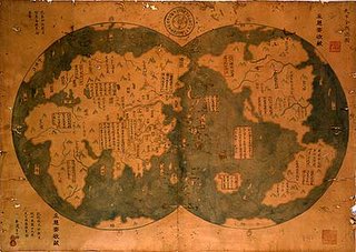
Further articles linked in Kartentisch discuss other exploits of Zhen He, who, as the tale tells, left China in 1405 with a fleet of several hundred ships and equipped with a rudimentary compass for navigation, and was able to round the Cape of Good Hope 76 years prior to Vasco Da Gama, circumanvigated the globe 100 years prior to Magellan, and surveyed Australia 300 years prior to Cook. If this tale is true, it certainly makes Zhen He a major figure in history.
I have little doubt that the Americas and other areas were visited and known to ancient peoples long prior to Columbus, for instance we have the Vinland sagas, Brendan the Navigator's tale, accounts of Basques and other early fishermen who knew the Grand Banks off the Newfoundland coast in Cabot's time, we know that Polynesians came to the coastal areas off of South America, and certainly Arab sailors knew the African and Asian coast and other areas far better than their European counterparts. Certainly some bias and ignorance comes into play, obscuring ancient knowledge. I do think that our predecessors deserve more credit for their knowledge than we generally afford them.
But to what extent does the Zhen He map make sense? It certainly could make good sense for 1763, but does it make sense for 1418? It would be interesting to know more about its history. Perhaps, like the Piri Reis map, it was compiled from multiple sources, some of which may have included Zhen He's accounts, and others which may have been more recent discoveries. At any rate, the map is both remarkable and beautiful. Tests are apparently underway in New Zealand to establish its authenticity.
Technorati tags:
atlas, cartography, China, evidence, geo, Geography, history, map, mapping, maps, navigation, news


0 Response for the " Chinese Discovery of America? "
Post a Comment