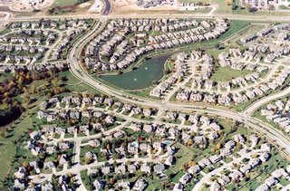
The GeoCarta blog discusses an article in the Rock Hill Herald (South Carolina), lamenting the latency in mapping data updates compared to the rapid development in many suburban areas with the sprouting of new residential developments right and left. Oh, the inconveniences of newspaper delivery, having to give directions, not being able to verify addresses in automated systems.
Missed the point on two much bigger and more serious issues that this rapid residential development also dredges up:
Emergency Response- without adequate mapping, emergency services must rely on verbal directions to dispatch and route responders, with risk of unfamiliarity with new developments and a potential for reduced response time.
Urban Sprawl- It points up the continuing trend of urban sprawl and conjures up all of the associated issues of wasteful land use and the decline of cities, increased need for infrastructure and increased dependency on vehicles, increased commute times, et cetera...
My humble opinion, I think someone's issues with home delivery of the newspaper pales in comparison...
Technorati tags:
activism, architecture, blog, cartography, community, design, developer, emergency response, environment, geo, Geography, gis, land ownership, mapping, navigation, news, opinion, planning, real property, sprawl, stewardship, sustainable development, urban sprawl


0 Response for the " Not on the map? "
Post a Comment