I have to admit, I am a Google Earth junkie, and as a technocrat, I have multiple machines at my desk. When one is going to be sitting semi-idle or running background tasks for any period of time, I sometimes fire up Google Earth on it, zoom in to a low altitude, put a slight angle tilt on the view, and set it at a lazy drift over some semi-randomly selected countryside.
Periodically, I will stop and sit in amazement at some of the scenery. Ancient ruins, meteor craters, breathtaking landscapes... the lunar landscape of the Libyan desert, you name it. I also periodically check out the goodies that sites like Google Earth Hacks have, as well as some of the other sites that track not just Google Earth, but other sites featuring imagery.
Google Karten tracks Google Maps, and picked up one of the more amazing things I've seen in a while... A cruise missile, captured in-flight over Utah...
Never know what you might discover...
Time to add GPS to the Swiss Army Knife?

It's also particularly ironic given the investments that the Swiss have made in quality geospatial products. Google Earth blog recently reported on getting imagery for the entire country of Switzerland at 50cm and many Swiss cities at 25cm, as well as improvements to the DTM models, with the entire country of Switzerland terrain at 10m resolution, and the Swiss Alps now high-res.
Geospatial Data, Security and Protecting the Public
 However, I do think that there are more things at stake than just military and homeland security's wishes for data to be controlled. There is also an aspect of protection of the public from accidental misuse of data, and intentional abuse of data. Where harm to the public may be an issue, typically professional licensure, security clearances, or other safeguards come into play.
There are many datasets that can fall into this category - for example, there have been several publicized cases involving the misuse of GIS tax parcel mapping to attempt to enforce such things as building setbacks and other ordinances, to the harm and detriment of property owners who may in retrospect have actually turned out to be in compliance with the ordinances - though in some instances only through costly litigation and/or demolition of a structure. In some instances, actual surveyed boundaries were rejected by undereducated GIS staff or other bureaucrats, in favor of digitized-and-rubbersheeted GIS parcel boundaries or misused COGO routines in the hands of people who do not have a solid understanding of surveying. Clearly this is unacceptable misuse of GIS data.
Among other things, I work extensively with GIS data for facilities, which may contain toxic or hazardous materials - certainly agencies which regulate their activities and emergency responders need to have ready access to what is onsite, and what the consequences of a catastropic event at one of these facilities might be on the community - but aside from keeping this data from the hands of would-be agents of terror, certainly that facility's competitors might be able to gain some competetive edge from knowing what this facility is working with. This is generally known as "Confidential Business Information" (CBI). It is a classified data category apart from the usual Governmental Secret or TS/SCI classification hierarchies.
Another area with tremendous potential for misuse is in traffic incident data - Departments of Transportation collect information on reported accidents and incidents, and plot them on roadway maps - the analysis of this can help the DOT in triaging, prioritizing, budgeting and sequencing improvements to the roadway for safety. However, in the wrong hands, this type of data can also lead to litigation - "you knew this was a bad intersection, yet you didn't do anything". Often a DOT is aware of problems for many years, but given budgetary or organizational constraints may be unable to act on them in as timely a fashion as would be liked - and a multimillion-dollar court award or settlement is generally only going to take away money from being able to address the problem properly.
 Another example from personal experience comes from some of the Emergency Response work we had done in conjunction with Hurricanes Katrina and Rita. Here, GIS data on accidental spills and contamination relating to the flood event must be captured, however given Agency issues with cost recovery, along with civil litigation and other issues, often this data must be tightly controlled, to avoid misuse which might undermine cleanup and remediation in the future.
These are just a handful of examples - many more come to mind. GIS is, at the end of the day, just a tool. The ever-emergent plethora of geospatial data and the ubiquitousness of GIS tools available to the public is certainly wonderful, however data and a tool in the hands of one, either without the adequate domain expertise to use the data properly - leading to unintentional harm; or the intentional abuse by one who wishes to exploit the data toward personal gain at expense of the public, or toward the outright, intentional harm of the public, can be a dangerous thing.
Looking for GIS integration experience

Technorati tags:
analysis, applications, ArcGIS, career, careers, developer, DoD, geo, Geospatial, GIS, j2ee, Java, job, jobs, map, mapping, maps, Military, Perl, Python, security, spatial, Vienna, Virginia
USACE Topographic Engineering Center
 As I mentioned in a prior post, the US Army Corps of Engineers Topographic Engineering Center was spotlighted at ESRI FedUC - CW4 Mike Harper gave an overview of quite a few interesting things going on in their enterprise, geared toward delivery of imagery and data down to the tactical level, along with collaborative data collection at the soldier level.
One interesting program is the award-winning BuckEye program, which gathers imagery using easily-deployable 39MP sensors, LIDAR, and other means, to provide imagery and DTM models which allow tremendous detail. Sample images shared with the audience included detail such as extension cords, individual slats of wooden pallets and other items to be identified - from imagery flown at 4000ft above the scene. These BuckEye soldiers and contractors have selflessly placed themselves in harms way toward gaining crucial data for military support, toward stabilizing volatile areas in Iraq and Afghanistan while minimizing noncombatant risk, particularly in urbanized areas, where detailed and granular intelligence is critical.
Other applications include the Urban Tactical Planner, Urban Skyline Explorer, and many others. Toward GPS and locational capabilities, TEC has been pursuing Defense Advanced GPS Receiver (DAGR), which allows military mapping products to be used as a backdrop - and as the demand for DAGR has outstripped production, TEC has also been working with Garmin toward allowing military mapping products from NGA to be brought into Garmin platforms as well.
Another interesting program described was in providing a framework for data collection at the tactical level - here soldiers can be debriefed or enter data directly, to be captured, geoenabled and databased, to provide a more transparent and collaborative means for sharing data at the tactical level.
Technorati tags:
3d, aerial photography, Afghanistan, analysis, applications, Army, cartography, collaboration, conference, coordination, DoD, DTM, federal, FedUC, Garmin, geo, Geospatial, GIS, GPS, imagery, Iraq, LIDAR, map, mapping, maps, Military, mobile, navigation, sensor, sensors, spatial, terrain
Galileo Blasted by British Drivers
 The Association of British Drivers has posted a scathing piece targeting Galileo, with ABD chairman Bryan Gregory saying "Galileo is not a light on the horizon, it is the entrance to an abyss."
While duly crediting some of the benefits of GPS and locational technology, the article looks upon Galileo in particular, as implemented by EU as yet another stealth tax, yet another way to have government monitoring where you go, who you go with, and so on.
The article states that Galileo is the primary mechanism planned for road tolling by the EU, with "car-hating" Britain to be first.
"The EU is already planning to use Galileo to enforce continental-wide road tolling, and the car-hating British government wants to be first. You won't be able to drive nywhere without the EU knowing where you are going, who you are travelling with, and what speed you are travelling at. They will be able to charge whatever they want. One journey, four lapses of concentration that take you slightly over the speed limit, and you'll be banned from driving."
The article further cites other "big brother" practices abroad, with Japanese law forbidding the sale of cellphones that aren't GPS-enabled from 2007 onward, and manufacturers being forced to fit all vehicles with GPS.
Technorati tags:
eu, Galileo, geo, geodesy, geodetic, Geospatial, gps, location-based, mapping, navigation, news, satellite, science, space, surveying
Global Warming reshaping the map
Recently there have been a few articles about political unrest between the US and Canada over coastal waters, to include the Canadian military patrolling these waters with armed icebreakers.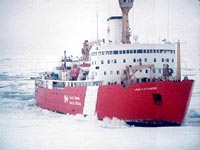
The main cause for concern is the reduction in surface area of multiyear ice along with a thinning of ice, which is working toward making the Northwest Passage across northern Canada a viable alternative for shipping. The Northwest Passage would present a route that is potentially up to 7,000 km shorter than using the Panama Canal. Canadian journal The Tyee has an interesting article that spells out and clarifies some of the specific issues and concerns, mainly revolving around policing and operations, such as liability issues associated with an arctic shipping route- oil spills, along with concerns about overexploitation of arctic fisheries, and the potential for entry of illegal weapons, drugs, or movement of WMDs by rogue nations.
Additionally the Tyee article lays out some of the history and confusion over ownership, with many arguments to either side about territorial waters and what Canada may or may not have legal jurisdiction over.
Certainly some very valid and important issues, which I hope our US diplomats can come to terms with and in fact offer a means of working with them together on, as opposed to butting heads. Currently it's my understanding that quite a bit of the cross-continental truck traffic in the US actually makes its way across from Pacific port to Atlantic port without a US destination in between- yet another sign of the intense demand for Atlantic/Pacific logistics. I would expect that a monitoring solution would include satellite-based remote sensing and communications platforms...
Technorati tags:
arctic, business, Canada, diplomacy, earth observation, emergency response, environment, environmental protection, exploration, geo, Geography, geopolitics, global warming, history, mapping, navigation, news, opinion, policy, remote sensing, rescue, satellite, security, stewardship
Beautiful maps and a look back in history...
Almost 20 years ago, practically right out of high school and through college, I started working in a surveyors' office- one that had tens of thousands of old plats and maps, some of which dated back to the turn of the century... I just love looking at old time surveyors' drawings from that time period- the lettering, the care and time they took drawing them just amazes me.
Claus Moser's Kartentisch blog discusses a site that has some gorgeous maps drawn by an Austrian surveyor named Johann Orth. I was reading Orth's story on the site- fascinating stuff. He was born 1929, pressed into service in the military for the tail end of WWII at the age of 16, ended up in a russian POW camp, and after the war worked as a surveyor, photogrammetrist, and cartographer for the Austrian government for 47 years, until he retired in 1981.
Since then he's been hand-drawing maps in that old style of what Vienna and various cities and places in Austria would have looked like at various points in time, going back two hundred years in time, based on his research and work with an Austrian museum- his maps are absolutely gorgeous.
Planauswahl (Index of plans)
Technorati tags:
Austria, blogs, cartography, design, geo, Geography, history, map, mapping, maps, photogrammetry, surveying , symbolization, Vienna
GLONASS complete by 2009?

Russian Information and News Agency Novosti is reporting that Russian Defense Minister Sergei Ivanov has announced in a report to Vladimir Putin that the GLONASS GPS system may be complete by 2009, far ahead of the initial schedule of 2012. Apparently Ivanov has determined that the program can be accelerated without any significant increase to cost. Ivanov states that benefits are geared toward civilian use, as opposed to military purposes. He states that by 2007, the GLONASS constellation could be fully servicing Russia, and by 2009 be fully servicing a global community. Perhaps some of these gains come through their partnership with India on space projects.
I wonder, yet again, how all this affects the aspirations of Galileo.
I have been tracking the unfolding GLONASS and Galileo saga (or perhaps slugfest?):
- GLONASS Status
- And yet more navigational satellites announced...
- Galileo Hype?
- Galileo / GIOVE-A
- Russian Christmas (GLONASS)
Technorati tags:
geo, geodesy, geodetic, Geospatial, glonass, gps, location-based, locative, map, mapping, maps, mobile, navigation, news, putin, russia, space, surveying
Galileo Hype?

Continuing on the discussion of Galileo and associated hype - In an opinion piece running in a few international newspapers, Canadian journalist Gwynne Dyer refers to some critics of Galileo calling it “the Common Agricultural Policy of the sky”, a reference to the EU’s "expensive and wasteful farm support program". Dyer further goes on to suggest it's "not commercial" and it's "not political" but nonetheless goes on about the reason behind the Galileo launch being to lessen reliance on what is a US military system, arguing that should the US shut Navstar down or resume S/A, many mission critical systems, such as flight control could be adversely affected. Well, it still sounds at least partly political to me...
At a cost of 3.2 billion Euros, that's a lot of money spent on what-ifs, notwithstanding the fact that other systems are also online (GLONASS) and in the process of lauch.
Dodging (for the moment at least) the more caustic digs made by a few other articles covering the Galileo launch, that virtually characterize Galileo as a "slap in the face to the American Empire", I would contend the same availability argument potentially applies to any such system, be it NAVSTAR GPS, GLONASS or even Galileo itself. If there's a problem with one of the SVs, constellation geometry is affected, and positional accuracy declines significantly or can become wholly unavailable due to poor Geometric Dilution of Precision factors. As a composite factor, GDOP is intimately tied with all aspects of horizontal and vertical location, along with time.
GDOP = √ σn2 + σe2 + σh2 + σt2 + c2
As surveyors we know that GPS constellations and ability to collect usable data is variable, based on the ever-changing collection of SVs available at a given point in time, making mission-planning and long observations a good idea. And this is WITHOUT the vagaries of S/A or wartime activities. Additionally, for survey-grade work, we rely on such tools as CORS stations and OPUS to perform correction. What correction of Galileo data will be possible? What ultimate levels of geodetic accuracy can we expect? Also, the discussion of "interoperability" between Galileo, Navstar and GLONASS leaves me perplexed. Currently Navstar and GLONASS are separate and not interoperable, so how could Galileo be interoperable? That interoperability piece will play itself out in the receivers in the ground-based processing of the data, and has little to do with Galileo.
"Killer App" and hypeworthy Galileo is not, at least as I currently understand the system. Particularly if it, as paid-subscriber-based offering competing with others that are free. But on the other hand, if we ultimately end up with multiple systems and plenty of availability and redundancy, so much the better.
Technorati tags:
applications, eu, Galileo, geo, geodesy, geodetic, Geospatial, gps, interoperability, mapping, navigation, satellite, science, space, surveying
USGS Cartographic Service Contracts
 We have been invited to participate in a solicitation for a USGS Cartographic Service Contract. It's great, as a small business, to be recognized for your capabilities and to be included in an opportunity to compete with the "big boys"- typically the ENR 200 firms.
We do plan to respond- we (and I would imagine many other firms) can easily address most aspects of the work, however one component still is the ability to provide imagery- it's not every company that is capable of deploying the aerial or spaceborne platforms and sensors for aerial imagery or other remote sensing imagery... We do have a few tricks up our sleeves, with a network of regional firms that have these conventional capabilities, as well as some advanced technology from some of our friends who do military contracting.
http://erg.usgs.gov/isb/pubs/factsheets/fs06603.html
New GPS Satellites readied

The first of the new GPS IIRs has been launched and is looking good so far, second has been delivered for a January launch
Lockheed Martin Delivers Second Modernized GPS Satellite to Cape Canaveral for January Launch
PRESS RELEASE
Date Released: Tuesday, November 8, 2005
Source: Lockheed Martin Corporation
First Satellite Performing Nominally During Critical On-Orbit Test Phase
Lockheed Martin (NYSE: LMT - News) has delivered the second modernized Global Positioning System Block IIR (GPS IIR) satellite to Cape Canaveral Air Force Station, Fla., where it will be readied for a January launch. The company is in the midst of modernizing a total of eight GPS satellites, designated GPS IIR-M, which will provide significantly improved navigation performance for U.S. military and civilian users worldwide.
The new satellites offer a variety of enhanced features for GPS users, such as a modernized antenna panel that provides increased signal power to receivers on the ground, two new military signals for improved accuracy, enhanced encryption and anti-jamming capabilities for the military, and a second civil signal that will provide users with an open access signal on a different frequency.
The first modernized GPS-IIR satellite, launched successfully on Sept. 25 from Cape Canaveral, is performing nominally following a series of precision maneuvers and deployment of all spacecraft systems. The team completed on-orbit operations ahead of the planned schedule and turned the spacecraft over to Air Force Space Command's 2nd Space Operations Squadron (2SOPS) in less than five days, a new record of any GPS satellite.
"The 2nd Space Operations Squadron is excited about the next generation of GPS satellites brought into the constellation," said Lt Col Steve Hamilton, Commander of the 2SOPS. "This was a total team effort by Lockheed Martin as well as other contractors, civil service and the Air Force working together to put these new capabilities on orbit. We're looking forward to a great check out and setting this satellite operational."
The spacecraft is expected to be declared fully operational for military and civilian navigation users around the globe in January 2006 following a special, four-month on-orbit test period for the new military and civilian signals.
"The highly successful launch and rapid on-orbit turnover of the first modernized GPS IIR is the result of a team of dedicated, talented individuals focused on delivering the best quality navigation capabilities to the user," said Dave Podlesney, GPS IIR program director, Lockheed Martin Space Systems in Valley Forge, Pa. "These are the most technologically advanced GPS spacecraft ever built and we look forward to achieving mission success as we prepare to launch another modernized satellite next year."
The Global Positioning System enables properly equipped users to determine precise time and velocity and worldwide latitude, longitude and altitude to within a few meters. Air Force Space Command's 2nd Space Operations Squadron, based at Schriever Air Force Base, Colo., manages and operates the GPS constellation for both civil and military users.
GPS IIR-M production occurs at Lockheed Martin facilities in Valley Forge, Pa. The modernized navigation payload is provided by ITT Industries in Clifton, N.J.
Headquartered in Bethesda, Md., Lockheed Martin employs about 135,000 people worldwide and is principally engaged in the research, design, development, manufacture and integration of advanced technology systems, products and services. The corporation reported 2004 sales of $35.5 billion.
CONTACT: Steve Tatum of Lockheed Martin, +1-408-742-7531, or Stephen.o.tatum@lmco.com.


 Posts
Posts