As we come up on this eve before Election day, I will pass along this humorous, yet true item from my friend Gene Kooper, Executive Director of the Professional Land Surveyors of Colorado.The below topo map fragment is from the Georgetown, CO 7 1/2 minute quad topo. In case you think it's bogus, the NGS Data Sheet is included. Regardless of your political views, please exercise your right to vote.
Whether you believe the brass cap is just a "pimple on a Grand Ol' Mountain" or a "Proud Shining Beacon of Democracy" atop a minor hill in the shadow of the Continental Divide, it doesn't matter!
In the end, we are all Americans.
GET OUT AND VOTE TOMORROW!!
1 National Geodetic Survey, Retrieval Date = NOVEMBER 3, 2008
KK2035 ***********************************************************************
KK2035 DESIGNATION - DEMOCRAT
KK2035 PID - KK2035
KK2035 STATE/COUNTY- CO/CLEAR CREEK
KK2035 USGS QUAD - GEORGETOWN (1974)
KK2035
KK2035 *CURRENT SURVEY CONTROL
KK2035 ___________________________________________________________________
KK2035* NAD 83(1992)- 39 42 51.68709(N) 105 44 07.70429(W) ADJUSTED
KK2035* NAVD 88 - 3781. (meters) 12405. (feet) VERTCON
KK2035 ___________________________________________________________________
KK2035 LAPLACE CORR- -11.78 (seconds) DEFLEC99
KK2035 GEOID HEIGHT- -12.45 (meters) GEOID03
KK2035
KK2035 HORZ ORDER - THIRD
KK2035
KK2035.The horizontal coordinates were established by classical geodetic methods
KK2035.and adjusted by the National Geodetic Survey in January 1993.
KK2035
KK2035.The NAVD 88 height was computed by applying the VERTCON shift value to
KK2035.the NGVD 29 height (displayed under SUPERSEDED SURVEY CONTROL.)
KK2035
KK2035.The Laplace correction was computed from DEFLEC99 derived deflections.
KK2035
KK2035.The geoid height was determined by GEOID03.
KK2035
KK2035; North East Units Scale Factor Converg.
KK2035;SPC CO C - 513,640.813 894,210.473 MT 0.99999314 -0 08 54.6
KK2035;SPC CO C - 1,685,169.90 2,933,755.53 sFT 0.99999314 -0 08 54.6
KK2035;UTM 13 - 4,396,313.019 436,959.085 MT 0.99964893 -0 28 11.8
KK2035
KK2035! - Elev Factor x Scale Factor = Combined Factor
KK2035!SPC CO C - 0.99940919 x 0.99999314 = 0.99940233
KK2035!UTM 13 - 0.99940919 x 0.99964893 = 0.99905833
KK2035
KK2035: Primary Azimuth Mark Grid Az
KK2035:SPC CO C - GRINDAL 152 24 17.9
KK2035:UTM 13 - GRINDAL 152 43 35.1
KK2035
KK2035|---------------------------------------------------------------------|
KK2035| PID Reference Object Distance Geod. Az |
KK2035| dddmmss.s |
KK2035| KK2034 GRINDAL APPROX. 8.1 KM 1521523.3 |
KK2035|---------------------------------------------------------------------|
KK2035
KK2035 SUPERSEDED SURVEY CONTROL
KK2035
KK2035 NAD 83(1986)- 39 42 51.68858(N) 105 44 07.70290(W) AD( ) 3
KK2035 NAD 27 - 39 42 51.73222(N) 105 44 05.69354(W) AD( ) 3
KK2035 NGVD 29 (07/19/86) 3779. (m) 12398. (f) VERT ANG
KK2035
KK2035.Superseded values are not recommended for survey control.
KK2035.NGS no longer adjusts projects to the NAD 27 or NGVD 29 datums.
KK2035.See file dsdata.txt to determine how the superseded data were derived.
KK2035
KK2035_U.S. NATIONAL GRID SPATIAL ADDRESS: 13SDD3695996313(NAD 83)
KK2035
KK2035 HISTORY - Date Condition Report By
KK2035 HISTORY - 1903 MONUMENTED USGS
KK2035 HISTORY - 1956 GOOD USGS
KK2035
KK2035 STATION DESCRIPTION
KK2035
KK2035'DESCRIBED BY US GEOLOGICAL SURVEY 1956 (EEM)
KK2035'RECOVERED AS DESCRIBED.
KK2035'
KK2035'STATION LOCATED 2 MI. W. OF GEORGETOWN, ON REPUBLICAN MOUNTAIN.
KK2035'
KK2035'POINT IS BEST REACHED BY FOLLOWING TRAIL UP FIRST PROMINENT GULCH N.
KK2035'OF GEORGETOWN, JUST AT THE CITY LIMITS. FOLLOW THIS TO SUMMIT OF
KK2035'MOUNTAIN, THENCE S. ALONG RIDGE TO HIGHEST POINT.
KK2035'
KK2035'STATION MARK--STANDARD BRONZE TRIANGULATION TABLET CEMENTED IN SOLID
KK2035'ROCK NEARLY AT HIGHEST POINT OF MOUNTAIN, STAMPED ---DEMOCRAT
KK2035'1903-1956---.
KK2035'
KK2035'REFERENCE MARK NO. 1--STANDARD USBR (1936) BENCH MARK TABLET CEMENTED
KK2035'IN SOLID ROCK, 5.07 FT. DISTANT FROM STATION MARK,
KK2035'S 36 DEG 40 MIN W
'Twas the Eve before Election Day...
The Lost Maps of Nagaland

The Times of India brings a story, speaking to the necessity of preserving maps and records dealing with boundaries - apparently the official maps depicting the boundary of the Indian state of Nagaland have gone completely missing.
Nagaland is a hill state in the foothills of the Himalayas, located in the far northeast of India, adjoining the Indian states of Assam, Arunachal Pradesh and Manipur, and bordering Myanmar (formerly Burma) to the east.
From the article,
At present, it looks like some of the details of the boundary will have to be recreated from surveys and whatever remaining documentation can be salvaged. The region has not been without its share of historic boundary disputes.
The government has lost all "original documents" — comprising details of boundaries — of Nagaland, in a glaring instance of callous handling of vital public documents.
The Union home ministry and the Assam government, which originally kept the records of Nagaland, do not even have the valid "map" of the state which ironically is in the throes of violence sparked by the demand to carve out Greater Nagaland by extending the existing boundaries of the state.
The matter came as a shock to home ministry officials when it was brought to light for the first time by Nagaland during its submission before the Local Commission on the Assam-Nagaland Border here last week.
In response to the commission's direction to submit before it the original documents of the state to settle boundary disputes, Nagaland said it was not in a position to give the written statement unless "its original documents which were purportedly lost by Assam" were returned.
New iPhones are out...
 Was just a little over a year ago that I shrugged at the release of the iPhone... Finally, they are coming through with some of the things I suggested quite a while back, primarily
- True GPS
- 3G data connection vs. EDGE
Almost as good as my AT&T Tilt now, but still doesn't run all of the mobile GIS apps I have.
US Streets
This is an interesting view of the United States:
 - found on Ben Fry's website, http://benfry.com/allstreets/index.html
The author compiled all local roads, and visual patterns of density and human use rapidly emerge. Here, a mix of physical barriers (such as valleys within the Appalachians) can be seen along with major corridors of development. There are still some blocks within some states which are not fully populated (shown as generally-rectangular, lighter-density areas in some of the midwest states), Fry ascribes this to differences in how roads are characterized and classified.
Thematic Mapping
 After just spending a chunk of time tonight reading article after article on his site, I have to give my kudos to Bjørn Sandvik, and his blog, Thematic Mapping -
There's just a ton of eminently cool and accessible stuff for visualization there...
Appalachian Electoral Dynamic?
I just came across an interesting blog, which presents a different spin on election dynamics, in the aftermath of the primary we just had here in Pennsylvania -
Here, counties in blue represent larger wins for Hillary Clinton, whereas the green counties represent larger wins for Barack Obama... "Appalachia" is outlined in black. During the 1992 presidential campaign, Democratic political consultant James Carville described Pennsylvania as "Philadelphia and Pittsburgh, with Alabama in between." - Now here's yet another similar analogy... I'm just presenting it as a Pennsylvania voter, reserving my own mix of comments, whether bemused or amused - I'll leave folks to draw their own conclusions...
"The Electoral Map" - http://theelectoralmap.com/
[edit - interestingly, the delineation of "Appalachians" on the map appears to concur more with congressional boundaries which generally touch on the Appalachian range]
Virtual Earth API Version 6.1

For developers using Virtual Earth, the Virtual Earth API version 6.1 was released a few days ago:
Official SDK Documentation: http://msdn2.microsoft.com/en-us/library/bb429619.aspx
Other discussion:
- Steve Lombardi's Blog (Microsoft) on 6.1 Enhancements: http://virtualearth.spaces.live.com/Blog/cns!2BBC66E99FDCDB98!14129.entry
- Chris Pendleton's Blog (Microsoft) on 6.1 Enhancements: http://blogs.msdn.com/virtualearth/archive/2008/04/11/new-virtual-earth-api-release-virtual-earth-6-1.aspx
- Johannes Kebeck's Blog on 6.1 Enhancements: http://johanneskebeck.spaces.live.com/Blog/cns!42E1F70205EC8A96!3858.entry
Overview of changes: http://msdn2.microsoft.com/en-us/library/bb412561.aspx
Virtual Earth Map Control SDK, version 6.1
What's New in the Map Control?
Welcome to version 6.1 of the Virtual Earth map control. This page explains the new features for version 6.0 and 6.1 on a high level. To see a detailed list of the objects, methods, and properties that have changed, see the Version Changelist.
Version 6.0 and 6.1 of the map control includes improvements in the following areas:
- Enhanced accuracy
- Additional functionality
- Enhanced performance
Enhanced Accuracy
The Virtual Earth team is committed to constantly improving the accuracy of the map control. This release of the map control includes improvements in the following areas.
- Enhanced Geocoding. The map control integrates multiple geocoders and datasets to provide the most relevant and accurate results. You can perform these searches using the VEMap.Find Method.
- Rooftop Geocoding. Rooftop locations are the most precise geocoding results available in the United States today. Rooftop geocoding is now available through the map control VEMap.Find Method.
- Consistent Pushpin Accuracy. When switching between aerial and birdseye views, pushpin accuracy is maintained, delivering a more seamless experience. Use the VEMap.SetShapesAccuracy Method to get the accuracy you desire.
Additional Functionality
This release of the map control includes additional functionality in the following areas.
- Printing support. Use the VEMap.SetPrintOptions Method to enable printing support.
- Reverse Geocoding. Reverse geocoding allows the user to find places based on a specific point on the map. Use the VEMap.FindLocations Method to accomplish this.
- Traffic-based Routes. A new option allows the use of available traffic information in route calculations, enabling quicker routes and more accurate route times during heavy traffic periods. Use the VERouteOptions.UseTraffic Property to turn on this feature.
- Birdseye Map Style with Labels. A road label overlay increases the usability of the Birdseye map style. This map style is called BirdseyeHybrid and is a new member of the VEMapStyle Enumeration.
- Walking Directions. Provide users the option to walk to their destination by returning walking directions instead of driving directions. To return walking directions, set the VERouteOptions.RouteMode Property to VERouteMode.Walking.
- Multipoint Routing. A new method takes multiple points for a route instead of just start and end points, allowing for more complex trip planning. Localized directions are also available in this version. Use the VEMap.GetDirections Method to get a multipoint route.
- Bulk Addition of Shapes. A new method to add multiple pushpins in one call while maintaining high performance and avoiding performance slowdowns. Use the VEMap.AddShape Method to add multiple pushpins.
- Improved Shape Control. You can now specify how a shape object appears relative to other shapes or tile objects, providing greater control in viewing data and objects. Use the VEShape Class to create shapes.
- MapCruncher (Beta). MapCruncher Beta for Microsoft Virtual Earth makes it easy to publish maps overlaid in an application using the Virtual Earth map control. See the MapCruncher Web page for further information.
- 3D Altitude Settings. Altitudes for three-dimensional objects can now be specified in meters.
- Updated interactive SDK. A new version of the Virtual Earth Interactive SDK is available, demonstrating the new functionality of the Virtual Earth Map Control. See the Virtual Earth Interactive SDK Web page for further information.
Enhanced Performance
There have been significant speed and accuracy improvements for pushpins and shapes, even in high numbers. Performance enhancements also include faster map panning.Version Changelist is available here: http://msdn2.microsoft.com/en-us/library/bb412440.aspx
Treasured Maps of New York City
 The New York Post has an article today, titled "Treasured Maps" - highlighting the work of Scott Stringer, who is charged with preserving historic maps of New York City - among them, the Randel Farm map, which laid out the grid of Manhattan Island from Houston to 155th St.
These historic maps show many features of streams, wetlands, lakes and other things which have since been reshaped through development - a timeline of the good, bad, and the ugly contained in a map repository going back to 1748.
The world needs more Scott Stringers - he is steward for New York County's maps - I unfortunately hear periodically of plenty of other instances where maps lie crumbling, for lack of proper preservation.
Phone Phun

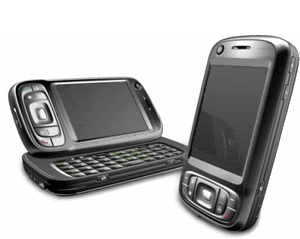
Does your phone do it all?
Lakota to reshape the US map?
 As reported by some news outlets, Lakota activists have sent a letter to the US State Department announcing their intention to secede from the United States.

Instant GPS-enabled Camera
Came across this interesting hack for the HTC TyTn II / AT&T Tilt:
With a registry editor, open HKEY_LOCAL_MACHINE\SOFTWARE\HTC\Camera\ - and in folder called P9, change the value "enabled"from 0 to 1.
And, voila:
 You now have an additional option button to select GPS Camera, and now your lat/long will be grabbed automagically from the integrated GPS to be embedded in the photo's EXIF tag.
Now if only I can find a hack for the camera's lag...
NeoGeo Wars...
Seems a post on All Points Blog regarding NeoGeography has unleashed a flurry of posts relating to "paleo" versus neo and a whole lot of other issues.
I think I have a slightly different of a take on it... I view the two as sort of a Venn diagram, with each representing expanding spheres, with an equally expanding area of overlap and merging between them.
Note, my little 5-minute Visio diagram is not by any means intended to be comprehensive... But the fuzziness and overlap is fully intended.
I do not view them as "in competition" - each has its own stakeholders and requirements, and between the two there is a considerable area of commonality. The exciting thing about neogeography, however, is that it's about empowerment and putting tools and capabilities into the hands of the public, which previously would have been inaccessible. Additionally, it's about fusion and collaboration - which benefits both communities.
And along the whole NeoGeo theme, I will leave with this:
Tabula Peutingeriana
Along the historic maps vein, another ancient map receiving a lot of press of late is the Tabula Peutingeriana - this one I find tremendously fascinating, being a view of the Roman world of nearly 2000 years ago. As a kid, I grew up in Germany, near Roman ruins of the Limes Germanicus and other features, and as such, I have always been fascinated with all things ancient.
Presently, the Tabula Peutingeriana is being added to the UNESCO Memory of the World Register as an important artifact, and, given its extreme fragility, was recently placed on public display for one day in Vienna on November 26th.
The Tabula Peutingeriana is a copy of a Roman cursus publicus, which was a schematic roadmap of roads, cities and other features as developed and used in the Roman Empire. There are no longer any known copies of the original Roman cursus publicus charts, however the Tabula Peutingeriana is believed to have been transcribed from an original one by a thirteenth-century monk in Colmar, and consists of a number of sheets with schematic diagrams showing stops along routes, very similar to a modern-day subway map.
As such, it displaces many features to fit the route rather than attempting to be cartographically correct, and as such, it does not represent latitude and longitude in a conventional sense - instead accomodating the routes and features along them first and foremost, resulting in a very long, skinny map generally oriented west to east.
The geographic extent of the map is staggering, spanning the British Isles to India and Sri Lanka, showing what would have been trade and military routes, the infrastructure and cultural exchange that would have gone on in Roman times.
One of the things that I was playing around with over the weekend is trying to match up features as shown on the Tabula Peutingeriana to modern features - one of the tools I was playing around with is Microsoft Research's MapCruncher for Virtual Earth:
While I wouldn't expect MapCruncher to be able to rubbersheet a schematic map such as the Tabula Peutingeriana to a conventional map, it has nonetheless given me many insights just in being able to match up ancient designations and routes to their modern counterparts in a managed fashion, and it has made for a fun rainy (or snowy, as the case may be) day project.
Remaining Mysteries of the Waldseemüller Map
Reuters is carrying a story about the preservation of the 1507 Martin Waldseemüller World map, the first known to refer to the New World as America.

Some of the individuals cited in the article express their puzzlement at how Waldseemüller was able to portray as much detail and accuracy as he did, given the extremely limited amound of knowledge that is generally believed to have been extant regarding the New World at this time - for example, Vasco Núñez De Balboa had not crossed the Isthmus of Panama to reach the Pacific until 1513, and likewise, Magellan had not rounded the southern tip of South America until 1520, yet these are shown.
Interestingly, many features in this map are reversed in subsequent maps by Waldseemüller.
The map is cited in the article as a 'keystone map', showing a fundamental shift in how Europe viewed the New World. It also raises many questions about how much we really understand geographic awareness and the availability of cartographic information in ancient times.
My own notion is that we sometimes do not give our predecessors enough credit for their knowledge of the world around them.
Mobile Geospatial
I finally got around to upgrading my mobile platform. I had been toting around my Motorola cellphone, iPaq, Holux GPSlim 240 bluetooth GPS, and all of the associated iGo tips and other associated cables...
I looked at a number of units, Blackberries, Treos, Nokia N95 (very nice), along with the Samsung BlackJack (BlackJack II coming soon), Motorola MotoQ and others - but ultimately narrowed things down to Windows Mobile, as I have a lot of software for that platform (ArcPad, navigation, et cetera) - and Windows Mobile can run your selection of Java VM as well - best of both worlds.
Yesterday, I ended up getting the HTC TyTn II (also known as AT&T Tilt and by a few other names) - and I'm pretty happy with it thus far. It's the only Windows Mobile unit that I came across to feature BlueTooth, WiFi, 3G Data, and integrated GPS. It also has a 3 megapixel camera to boot.
I'm still looking to pick up a nice big MicroSD card, so I haven't yet loaded it up with a lot of stuff, but I have been playing with Google Maps Mobile, Microsoft Live Search Mobile (Virtual Earth), and Mobile GMaps on the Esmertec JBed JVM that ships already installed on the HTC unit. Notably, when I went to Esmertec's site, I was greeted with an Android info page, so I may be looking at gPhone apps as well.
Pretty nice, so far! I am looking forward to developing some things that take advantage of this new platform...
Thanksgiving
I did find a few interesting maps relating to the early Plymouth Colony at this site: http://etext.virginia.edu/users/deetz/Plymouth/plymaps.html

This would have been the colonists' view of New England, as they set sail - from the website description,
Captain John Smith's map of New England, dated 1614.
The map was probably drawn by Simon van der Passe, the son of a Dutch engraver, based on one drawn by John Smith. It is very similar to an earlier version which omitted the "New" which prefaces "Plimouth," and does not include Salem. The English colonists who settled in Plymouth in 1620 almost certainly had access to this map. In his Advertisements for the Unexperienced Planters of New England, or Any Where (London, 1631), Smith commented wryly: "Now since them called Brownists went, some few before them also having my bookes and maps, presumed they knew as much as they desired . . . " (The Complete Works of Captain John Smith (1580-1631), ed. by Philip L. Barbour (Univ. Of North Carolina Press, 1986), vol. 3, p. 285.
Reprinted in Deetz and Deetz, The Times of Their Lives, p. 70.
Also featured in this map archive is the following:

The only known map of the town layout, as drawn by William Bradford in 1620. From the site,
William Bradford's sketch of the town of Plymouth.
The Bradford sketch, entitled "The meersteads & garden plots of which came first layed out 1620" is the only known map of the original town layout. The sketch is bound into the front of a manuscript volume entitled "Plimouths Great Book of Deeds of Lands Enrolled from Ano 1627 to Ano 1651." The first part of the volume is in the handwriting of Governor William Bradford, as is the map. The volume now comprises Vol. 12 , Deeds, &c. Vol. 1 1620-1651 of The Records of the Colony of New Plymouth in New England, edited by Nathaniel B. Shurtleff and David Pulsifer (William White, 1855-61; AMS Press, 1968).
John A. Goodwin, in his The Pilgrim Republic (Boston: Houghton Mifflin, 1920; Kraus reprint 1970), has extended the plan to include his interpretation of the position of occupants on the north side of the street, and of the street in relation to the harbor and the fort.
The original Bradford sketch is reprinted in Deetz and Deetz, The Times of Their Lives, p. 66.
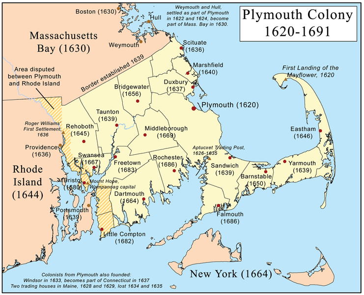
Finally, from Wikipedia's entry on the Plymouth Colony, a map showing the geographic extent of the Plymouth Colony:
Puget Sound Information Challenge
Posting live from EPA's Environmental Symposium in St. Louis - One of the things that's being discussed there is a challenge put forth by Bill Ruckelshaus, former EPA Administrator, who is now heading up the Puget Sound Initiative, to clean up this natural resource that forms a big part of Northwest Washington State.
As part of this, they established a wiki, and are having mashup camps to rapidly get as much content relating to Puget Sound and its' environment as possible:
In a few short hours, I was able to develop a Virtual Earth mashup, which performs MetaCarta searches against EPA and other federal and state documents, pulls in EPA Toxic Release Inventory for Washington State as a KML layer, WMS layers for USGS Wetlands and Land Cover (NLCD), as well as NHD layers showing streams and impaired waters.
There is also a great OpenLayers-based mashup builder and other tools - anyone interested in improving the environment in the Puget Sound area will be encouraged to participate as things move forward.
I also built a standalone version here: http://www.synergist-tech.com/Demo1/PugetSound.html
Seeking Web GIS Applications Developers...

Synergist Technology Group, Inc. is currently looking for GIS web applications developers, for its Pennsylvania and Northern Virginia locations.
Requirements:
Strong background in web-based GIS applications development.Desired Skills:
- DHTML, CSS, and JavaScript;
- ASP.NET, C#, VB.NET, or Java
- ESRI ArcIMS
- Web Services (XML, SOAP, JSON, REST, OGC)
- Understanding of spatial databases
ArcGIS Server, Oracle Spatial query and analysis, mashups and exposure to Microsoft Virtual Earth, Google Earth, Google Maps, good documentation and communication skills.
Additionally, a background in emergency response, transportation, facilities management or environmental science may be very useful.
Applying:
Applicant must be a US Citizen or have US Permanent Resident Status
Interested applicants should respond with a current curriculum vitae and salary requirements to dsmith[@]synergist-tech.com.
Synergist Technology Group, Inc. - A Service-Disabled Veteran-Owned Small Business (SDVOSB) specializing in geospatial technology, environmental science, transportation and emergency response.
Vector Data, SOA and Scalability
 One of the things I am still trying to get my head around is scalability in vector-based web services, such as OGC Web Feature Services or ArcIMS Feature Services. Certainly with image services, one can do a lot of magic behind the scenes - such as tiling, caching, load balancing.
In many instances, an image service will suffice well, but for power users, for ad-hoc queries and analysis, the full geometry and attribute data is often needed. And in the case of a distributed enterprise, here is one place where a purely SOA-oriented approach begins to break down.
Things becomes a bit more difficult when it comes to vector geometry, as most GIS clients are still only geared toward consuming and processing vector data in one chunk.

Further, vector geometries can't well be broken into tiles without causing other breakage - polygons and linear features need to retain their topological integrity in order to work.
Yes, one can certainly cache vector feature services, provided the underlying data is relatively static, or apply constraints limiting the amount of data that one can fetch at a time, but is there any possibility, looking down the road, of utilizing more efficient serial or multiple parallel processes to rapidly and efficiently stream large and complex vector datasets?
I think there will need to be, and I don't yet see OGC, ESRI or anyone else looking at this. I'd be interested in hearing other folks' thoughts and experiences on this...
ESRI Plenary, yet more notes...
ESRI International User Conference 2007
Plenary Session, 6/18/2007 - Continued
Here continues my posting of notes from the UC... Still enumerating new features for 9.3...
Multiple Views
Yes, the much-awaited multiple views for ArcGIS Desktop 9.3 are coming...
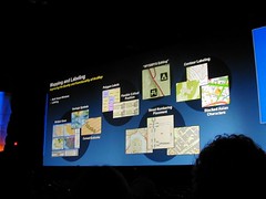
Labeling
9.3 brings enhanced label management, with a "pause labeling" feature, which skips labels in interim operations, and thereby allows faster redraws and navigation.
Polygon labeling offers new options as well - "label at fixed position within polygon", labeling of all polygons on a given layer at upper right, lower left, bottom center, and so on.
Contour labeling has been enhanced, to allow groups of contour labels to be linear, in holding with cartographic standards.
A "river labeling" style has been added, to better follow rivers.
WYSIWYG Editing
ArcGIS 9.3 brings true What-You-See-Is-What-You-Get (WYSIWYG) editing of features and for cartographic representations. Currently, when a user drags an entity, it is shown in wireframe mode, but 9.3 dynamically shows what the actual feature will look like while being dragged.
Overlaps
9.3 has functionality that highlights overlaps, as well as a great new "disperse markers" feature, which allows overlapping markers to be automatically rearranged in a number of styles.
Cartographic Representations
For tips and tricks for enhanced cartographic standards and representations, and toward optimizing features and functionality in ArcGIS Desktop 9.3, ESRI has set up a "Mapping Center" website, located at http://mappingcenter.esri.com/.
Job Tracking Extension (JTX)
The new Job Tracking Extension offers interesting new functionalities for ArcGIS Desktop and Server 9.3. Essentially, it tracks and manages workflows.
(more to follow... trying to catch up with family first)


 Posts
Posts

