I finally got around to upgrading my mobile platform. I had been toting around my Motorola cellphone, iPaq, Holux GPSlim 240 bluetooth GPS, and all of the associated iGo tips and other associated cables...
I looked at a number of units, Blackberries, Treos, Nokia N95 (very nice), along with the Samsung BlackJack (BlackJack II coming soon), Motorola MotoQ and others - but ultimately narrowed things down to Windows Mobile, as I have a lot of software for that platform (ArcPad, navigation, et cetera) - and Windows Mobile can run your selection of Java VM as well - best of both worlds.
Yesterday, I ended up getting the HTC TyTn II (also known as AT&T Tilt and by a few other names) - and I'm pretty happy with it thus far. It's the only Windows Mobile unit that I came across to feature BlueTooth, WiFi, 3G Data, and integrated GPS. It also has a 3 megapixel camera to boot.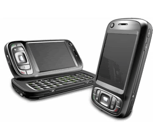
I'm still looking to pick up a nice big MicroSD card, so I haven't yet loaded it up with a lot of stuff, but I have been playing with Google Maps Mobile, Microsoft Live Search Mobile (Virtual Earth), and Mobile GMaps on the Esmertec JBed JVM that ships already installed on the HTC unit. Notably, when I went to Esmertec's site, I was greeted with an Android info page, so I may be looking at gPhone apps as well.
Pretty nice, so far! I am looking forward to developing some things that take advantage of this new platform...
Mobile Geospatial
On
11/29/2007 08:06:00 AM
1
comments
Categories:
.net
,
ArcPad
,
AT_T Tilt
,
developer
,
ESRI
,
geo
,
Geospatial
,
GIS
,
Google Maps
,
GPS
,
handheld
,
htc
,
internet
,
Java
,
map
,
maps
,
mobile
,
programming
,
TyTn II
,
Virtual Earth
Subscribe to:
Post Comments
(
Atom
)


I read your blog now and then and understand you have experience in using the At&t
tilt phone onboard GPS with ArcPad.
I was wondering if you know how to configure the onboard gps to work with the tile.
ArcPad finds a gps on com 4 but when i set the gps active in arcpad with a projected
layer or any layer for that matter it states "no current position fix available"
Any help would be greatly appreciated.
Kind Regards,
Charles