USGIF Accepting Applications for 2007 Scholarship Program
Foundation to Award $50,000 to Promising Students Studying the Geospatial Tradecraft
HERNDON, Va.--The United States Geospatial Intelligence Foundation (USGIF) is currently accepting entries for its 2007 USGIF Scholarship Program.
All graduate and undergraduate students studying fields relating to the geospatial tradecraft are encouraged to apply. USGIF also will award scholarships to well-qualified high school seniors planning to enter a geospatial- or GIS-related program at the college or university level. Applications can be found on the Foundation’s website at www.usgif.org/Education_Scholarships.aspx.
“We are pleased to again be able to offer scholarships at the high school, undergraduate, and graduate levels as we help provide for the future of the geospatial intelligence tradecraft,” said USGIF President and Chairman K. Stuart Shea.
Students have until June 1, 2007, to submit their applications. USGIF plans to award more than $50,000 in scholarships. The number of scholarships awarded will be based on the number of qualified applications and the selection of the Foundation’s Scholarship Committee. Applications will be evaluated on a peer-to-peer basis in each of the four categories, assessing the qualifications of Ph.D. candidates relative to other Ph.D. candidates, master’s candidates to other master’s candidates, and so on. Winners will be announced in early-August.
Last year, USGIF recognized 12 promising future contributors to the geospatial intelligence tradecraft: two Ph.D. candidates, four master’s candidates, three undergraduates and three high school seniors. High school winners received $2,000 and the other winners received $5,000.
“USGIF’s commitment to supporting the education and academic success of students interested in the geospatial intelligence tradecraft is paramount,” said Shea. “We carry out our academic mission with the same passion as we have for supporting our national security objectives.”
USGIF is a Virginia-based non-stock, not-for-profit corporation. The Foundation is dedicated to promoting the geospatial intelligence tradecraft and developing a stronger community of interest between government, industry, academia, professional organizations and individuals whose mission focus is the development and application of geospatial intelligence data and geo-processing resources to address national security objectives. USGIF produces the Nation’s Premier Intelligence Event, the GEOINT Symposium, which takes place this year Oct. 21-24 at the Henry B. Gonzalez Convention Center in San Antonio, Texas. For more information on the Foundation and GEOINT, visit http://www.usgif.org/.
I was delinquent in posting this pic from the 2007 ESRI FedUC...
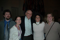
A group of colleagues from the USEPA contracting world - From left to right: Myself, Jessica Zichichi (Innovate!), Jack Dangermond, Claudia Benesch (CSC - Agency Central Support) and Catherine Harness (CSC - GeoData Gateway Lead)
This was the reception at the Organization of American States - and yes, that is a map on my necktie...
Technorati tags:ArcGIS, arcgisserver, conference, ea, EDN, enterprise architecture, ESRI, ESRI developer network, federal, FedUC, geo, Geospatial, GIS, Intel, map, mapping, maps, metadata, OGC, spatial, trade shows, user interfaces, Washington, webmapping, WFS
 A provocative title for the post...
The FedUC conference wrapped up with an excellent lunch (aside from the staple in my veggies)... and a great presentation from CW4 Michael Harper of the USACE Topographic Engineering Center on Buckeye, DAGR and other interesting things going on there... may merit a separate post.
The good Doctor provided, as he so often does, a great Q&A session as a wrap-up. Some of the bullets from that discussion
- East coast tech support is coming - ESRI is standing up a tech-support team in North Carolina, to offer expanded AM hours, beginning at 6AM. Additionally, they may investigate the possibility of better search capabilities in the online tech support material, via Google.
- ESRI continues to work with the University of Redlands, with the 1-year Masters program - potentially to be expanded to similar programs at George Mason for those of us working in the DC area. The DC area is a hotbed of geospatial activity, with good talent scarce.
- Mr. Dangermond described some interesting things he has going on internally, to provide real-time financial reporting on the state of ESRI - which, no surprise - are geo-enabled. Being able to get this kind of reporting is an area of interest which I have no doubt will grow in other firms with a broad geographic reach.
- In conjunction with FedUC was the first Classified ESRI GIS community meeting, attended by 300 or so - featuring discussion of applications in the TS/SCI NOFORN arenas. Typically the pitfall is stovepipes, but being able to get cleared personnel together to discuss topics of common interest will be a boon to the DoD/Intel community.
- ESRI is trying to bolster its Java support, with their Java team growing and building better support for Java classes.
- The Geography Network is to be overhauled, and replaced with a more robust, more collaborative version.
- 9.3... Saving goodies for last. The 9.3 beta is scheduled for sometime this summer, probably around the Conference. Some improvements in the hopper for 9.3 include interoperability and OGC, improvements to ArcGIS Server, Mobile Applications development support, and addressing stability and known issues with 9.2. They are also looking at PostgreSQL.
- A next iteration is probably a year to year and a half away yet. Here, the focus will be simplification of the user interface, support for multiple views and multiple documents, and capability of storing all types of geofiles in a geodatabase - such as metadata catalogs, and so on.
Technorati tags:
ArcGIS, arcgisserver, conference, ea, EDN, enterprise architecture, ESRI, ESRI developer network, federal, FedUC, geo, Geospatial, GIS, Intel, map, mapping, maps, metadata, OGC, spatial, trade shows, user interfaces, Washington, webmapping, WFS


