Surveying, Mapping and GIS

Exploring all aspects of mapping and geography, from field data collection, to mapping and analysis, to integration, applications development and enterprise architecture...

  • Geospatial Technology, End to End...

    Exploring all aspects of mapping and geography, from field data collection, to mapping and analysis, to integration, applications development, enterprise architecture and policy
Showing posts with label history. Show all posts

A Blast from the Past

Posted by Dave Smith On 3/31/2009 07:38:00 PM 10 comments

Some late night discussion with @GeoBabbler (Bill Dollins) and others last night led to this little flight of fancy...  Bill was wondering if there were still any old copies of ArcView 1.0 around.  Being a GIS geezer and a bit of a technology packrat, it turns out I still had a copy.  Scary.  As @FantomPlanet suggested, I reckon I have a bit of a Museum of GIS Antiquity going on - I believe I actually still have ancient copies of MapInfo, Atlas, GeoMedia, AutoCAD Map 1.0 and others floating around, plus quite a bit of hand-coded stuff from the days when COTS GIS was not even widely available.


Scarier yet, I still have copies of MS-DOS and Windows 3.1 around.  

And...  to top it off, I was actually able to lay my hands on them and try things out again.

Actually, what I did was stand up a VirtualBox instance and load up Windows for Workgroups 3.11 (ArcView 1 does not run on Win95 and up) and lo and behold, I then got ArcView 1.0 loaded up.

Prepare to enter the time machine and go back over 15 years into the past:
Above:  Note the MDI interface
Above:  Supplied "neweng.av" Tutorial data with choropleth mapping of New England...

Above:  Version "1.0a"

Above:  "maplewd.av" Tutorial data...

Supported data types: Arc/Info coverages, workspaces images (note .bil image supplied as part of the AV1.0 tutorial data), address coverage...  Note also that shapefiles are NOT supported.


An interesting look at the past. A capable GIS viewing and querying tool, though no editing capability was supplied with 1.0. So... Why would one want to load up ArcView 1.0? You probably don't - probably best to live vicariously through my little adventure here. But... if you ever do, VirtualBox provides some dicey support for it (I did still get the divide By zero error initially, but eventually it started working) - and, you can actually still download a copy of 1.0 here: ftp://download1.geocomm.com/sd2/ARCVIEW10.ZIP and if you still have a copy of MS-DOS and Windows 3.1, you should be good to go.
Fun stuff!  Brought back some memories...

[edit - removed the hyperlinks from the images (and thereby the preview snapshots, per comment below)...  not sure why blogger wants to insert them by default anyways...]

Magnetic Declination

Posted by Dave Smith On 12/01/2008 05:14:00 PM 1 comments


For folks working with historic deeds and bearing references, there are a number of tools available -


Additionally, there is a freeware tool available from Resurgent Software, which will compute historic declinations to 1600: http://www.resurgentsoftware.com/geomag.html

Further online tools and resources for geomagnetism and computation:

EDIT: And an additonal one suggested by Chuck Conley from Canada's Geological Survey

Penn State Geography - Interdisciplinary Conference

Posted by Dave Smith On 11/10/2008 02:02:00 PM 1 comments


From my colleagues at the Penn State Department of Geography:

Please share with colleagues or students who might be interested. Note that the conference is open to undergraduate as well as graduate students, and Sunday's session (sponsored by our SWIG -- Supporting Women in Geography--chapter) will focus on professional development/networking; former AAG President Jan Monk will be the keynote speaker.

The CFP is available as a PDF document at http://www.geog.psu.edu/noboundaries/noBoundaries2009_CFP_Poster_final.pdf

Additional information, including updates as available, can be found at http://www.geog.psu.edu/noboundaries

***********************************************


The graduate students of the Penn State DEPARTMENT OF GEOGRAPHY invite graduate & undergraduate students to present their research at our annual interdisciplinary conference, which takes place on Penn State's University Park campus Saturday, February 28-Sunday, March 1, 2009.

We welcome submissions on subjects including:

Politics, economics, and international development; Ecology and environmental sciences; History, culture, and society; Gender, race, class, and sexuality; Urban & rural policy and planning; Hazards, vulnerability, and global change; GIS, spatial analysis, and geovisualization.

What unites us (and hopefully you) is an attention to space and place, scale, and connections between the human and physical realms. If your research intersects with any of the above, please join us! (more

information: www.geog.psu.edu/noboundaries)


PAPER SESSIONS

Paper sessions will be organized along common themes with 20 minute timeslots (15 minute presentations followed by a 5 minutes of Q and A).

If you would like to present your research, send a title and abstract (250 words or less) to noboundaries@psu.edu.


POSTER SESSIONS

Graduate and undergraduate students are invited to present posters. Send a title and abstract (250 words or less) to noboundaries@psu.edu.

SPECIAL SESSION: BALANCING ON THE ACADEMIC LADDER—SUPPORTING WOMEN IN

GEOGRAPHY AND BEYOND

Creating supportive spaces for a diversity of women within academia is an ongoing process that involves personal and political action at a variety of scales. This year’s special session of the no)BOUNDARIES conference looks to acknowledge the successes as well as the challenges faced by those striving to create a more supportive academic environment for all women.

We are soliciting papers for panel sessions on the themes of:

- Life in the Department: Departmental Climate; Mentoring; Access to Information; Student Organizations (e.g. Supporting Women in Geography)

- Life Beyond the Department: Publishing; Work/Life Balance; Career Track; Outreach; Networking


These are merely suggested topics; we welcome any and all contributions.

Balancing on the Academic Ladder will consist of workshops as well as panel sessions to encourage the generation and exchange of creative ideas and strategies. Send paper abstracts to noboundaries@psu.edu.


Submission deadline for abstracts is February 1, 2009


To The Bard...

Posted by Dave Smith On 1/25/2008 11:00:00 PM 0 comments

A Bard's Epitaph

Is there a whim-inspired fool,
Owre fast for thought, owre hot for rule,
Owre blate to seek, owre proud to snool,
Let him draw near;
And owre this grassy heap sing dool,
And drap a tear.

Is there a bard of rustic song,
Who, noteless, steals the crowds among,
That weekly this area throng,
O, pass not by!
But, with a frater-feeling strong,
Here, heave a sigh.

Is there a man, whose judgment clear
Can others teach the course to steer,
Yet runs, himself, life's mad career,
Wild as the wave,
Here pause-and, thro' the starting tear,
Survey this grave.

The poor inhabitant below
Was quick to learn the wise to know,
And keenly felt the friendly glow,
And softer flame;
But thoughtless follies laid him low,
And stain'd his name!

Reader, attend! whether thy soul
Soars fancy's flights beyond the pole,
Or darkling grubs this earthly hole,
In low pursuit:
Know, prudent, cautious, self-control
Is wisdom's root.

Robert Burns (25 January 1759 – 21 July 1796)

Treasured Maps of New York City

Posted by Dave Smith On 1/14/2008 12:41:00 PM 0 comments

The New York Post has an article today, titled "Treasured Maps" - highlighting the work of Scott Stringer, who is charged with preserving historic maps of New York City - among them, the Randel Farm map, which laid out the grid of Manhattan Island from Houston to 155th St.

These historic maps show many features of streams, wetlands, lakes and other things which have since been reshaped through development - a timeline of the good, bad, and the ugly contained in a map repository going back to 1748.

The world needs more Scott Stringers - he is steward for New York County's maps - I unfortunately hear periodically of plenty of other instances where maps lie crumbling, for lack of proper preservation.

Lakota to reshape the US map?

Posted by Dave Smith On 12/24/2007 09:33:00 AM 1 comments

As reported by some news outlets, Lakota activists have sent a letter to the US State Department announcing their intention to secede from the United States.


To provide context, there were several treaties between the US and the Lakota, such as the 1855 Fort Laramie treaty which granted the Lakota sovereignty, but allowed passage along the Oregon Trail - however unease between the Lakota and whites continued, following with the 1868 Fort Laramie treaty - but once gold was discovered in the Black Hills (sacred to the Lakota), all bets were off, leading to the infamous battles of Little Big Horn, where General Custer's forces were defeated, and the killing of Sitting Bull (shown on the right) at Standing Rock, and the Massacre at Wounded Knee, where 150 Lakota and 25 US soldiers were killed. The Lakota were ultimately forced to sign a treaty in 1877, ceding the Black Hills to the US, but there has been longstanding discontent over the disenfranchisement of the Lakota and loss of their sacred Black Hills.

In 1980, a proposed settlement of $122 million was offered to the Lakota by the US government, however as this did not include a return of lands, it was refused.

The potential extent of the Lakota nation is shown in the map below (current reservations shown dark red, 1868 Treaty boundary in yellow):

Tabula Peutingeriana

Posted by Dave Smith On 12/04/2007 12:59:00 PM 1 comments

Along the historic maps vein, another ancient map receiving a lot of press of late is the Tabula Peutingeriana - this one I find tremendously fascinating, being a view of the Roman world of nearly 2000 years ago. As a kid, I grew up in Germany, near Roman ruins of the Limes Germanicus and other features, and as such, I have always been fascinated with all things ancient.

Presently, the Tabula Peutingeriana is being added to the UNESCO Memory of the World Register as an important artifact, and, given its extreme fragility, was recently placed on public display for one day in Vienna on November 26th.

The Tabula Peutingeriana is a copy of a Roman cursus publicus, which was a schematic roadmap of roads, cities and other features as developed and used in the Roman Empire. There are no longer any known copies of the original Roman cursus publicus charts, however the Tabula Peutingeriana is believed to have been transcribed from an original one by a thirteenth-century monk in Colmar, and consists of a number of sheets with schematic diagrams showing stops along routes, very similar to a modern-day subway map.


As such, it displaces many features to fit the route rather than attempting to be cartographically correct, and as such, it does not represent latitude and longitude in a conventional sense - instead accomodating the routes and features along them first and foremost, resulting in a very long, skinny map generally oriented west to east.

The geographic extent of the map is staggering, spanning the British Isles to India and Sri Lanka, showing what would have been trade and military routes, the infrastructure and cultural exchange that would have gone on in Roman times.

One of the things that I was playing around with over the weekend is trying to match up features as shown on the Tabula Peutingeriana to modern features - one of the tools I was playing around with is Microsoft Research's MapCruncher for Virtual Earth:

While I wouldn't expect MapCruncher to be able to rubbersheet a schematic map such as the Tabula Peutingeriana to a conventional map, it has nonetheless given me many insights just in being able to match up ancient designations and routes to their modern counterparts in a managed fashion, and it has made for a fun rainy (or snowy, as the case may be) day project.

Remaining Mysteries of the Waldseemüller Map

Posted by Dave Smith On 12/04/2007 12:37:00 PM 1 comments

Reuters is carrying a story about the preservation of the 1507 Martin Waldseemüller World map, the first known to refer to the New World as America.


Some of the individuals cited in the article express their puzzlement at how Waldseemüller was able to portray as much detail and accuracy as he did, given the extremely limited amound of knowledge that is generally believed to have been extant regarding the New World at this time - for example, Vasco Núñez De Balboa had not crossed the Isthmus of Panama to reach the Pacific until 1513, and likewise, Magellan had not rounded the southern tip of South America until 1520, yet these are shown.


Interestingly, many features in this map are reversed in subsequent maps by Waldseemüller.

The map is cited in the article as a 'keystone map', showing a fundamental shift in how Europe viewed the New World. It also raises many questions about how much we really understand geographic awareness and the availability of cartographic information in ancient times.

My own notion is that we sometimes do not give our predecessors enough credit for their knowledge of the world around them.

Thanksgiving

Posted by Dave Smith On 11/23/2007 10:17:00 AM 0 comments

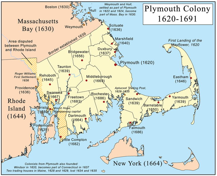
I certainly have much to be thankful for this year, and celebrated a nice Thanksgiving with family. The traditional imagery of Thanksgiving, of puritan English pilgrims celebrating a feast of thanks with the indiginous Americans leaves me with many mixed thoughts given the later fate of indiginous people, a discussion perhaps best left for another day.

My own family first came to New England in 1623, not long after this first Thanksgiving, with Governors Thomas Dudley and Simon Bradstreet (Massachussetts Bay Colony), also Puritans, being among my ancestors.

I did find a few interesting maps relating to the early Plymouth Colony at this site: http://etext.virginia.edu/users/deetz/Plymouth/plymaps.html


This would have been the colonists' view of New England, as they set sail - from the website description,


Captain John Smith's map of New England, dated 1614.

The map was probably drawn by Simon van der Passe, the son of a Dutch engraver, based on one drawn by John Smith. It is very similar to an earlier version which omitted the "New" which prefaces "Plimouth," and does not include Salem. The English colonists who settled in Plymouth in 1620 almost certainly had access to this map. In his Advertisements for the Unexperienced Planters of New England, or Any Where (London, 1631), Smith commented wryly: "Now since them called Brownists went, some few before them also having my bookes and maps, presumed they knew as much as they desired . . . " (The Complete Works of Captain John Smith (1580-1631), ed. by Philip L. Barbour (Univ. Of North Carolina Press, 1986), vol. 3, p. 285.

Reprinted in Deetz and Deetz, The Times of Their Lives, p. 70.


Also featured in this map archive is the following:


The only known map of the town layout, as drawn by William Bradford in 1620. From the site,


William Bradford's sketch of the town of Plymouth.

The Bradford sketch, entitled "The meersteads & garden plots of which came first layed out 1620" is the only known map of the original town layout. The sketch is bound into the front of a manuscript volume entitled "Plimouths Great Book of Deeds of Lands Enrolled from Ano 1627 to Ano 1651." The first part of the volume is in the handwriting of Governor William Bradford, as is the map. The volume now comprises Vol. 12 , Deeds, &c. Vol. 1 1620-1651 of The Records of the Colony of New Plymouth in New England, edited by Nathaniel B. Shurtleff and David Pulsifer (William White, 1855-61; AMS Press, 1968).

John A. Goodwin, in his The Pilgrim Republic (Boston: Houghton Mifflin, 1920; Kraus reprint 1970), has extended the plan to include his interpretation of the position of occupants on the north side of the street, and of the street in relation to the harbor and the fort.

The original Bradford sketch is reprinted in Deetz and Deetz, The Times of Their Lives, p. 66.

Finally, from Wikipedia's entry on the Plymouth Colony, a map showing the geographic extent of the Plymouth Colony:


Perilous Occupation

Posted by Dave Smith On 3/11/2007 10:55:00 AM 0 comments

Mike Berry found this interesting advertising insert card in a collection of advertising images from 1850-1920 housed at Duke University - these are from from the W. Duke Sons Tobacco Company. This series is from "50 Scenes of Perilous Occupations". The exhibit places Surveying between Circus Knife Throwing and Indian Scout...

St. Patrick's Parade

Posted by Dave Smith On 3/10/2007 09:58:00 PM 0 comments


Today, my town of Scranton PA celebrated its' annual St. Patrick's Day Parade. Scranton is blessed with one of the largest St. Pat's parades in the nation - this year, the line-up included 7,000 people, with 11 high school bands, 10 bagpipe bands and 13 other string and performing groups. Scranton has a heritage rich with Irish culture, with a St. Patricks Day Parade tradition going back to 1862.


Message In A Bottle

Posted by Dave Smith On 3/05/2007 12:41:00 PM 0 comments


Jerry Penry has just published an interesting article for American Surveyor magazine, discussing how ocean currents are mapped and tracked - one of these means being drift bottles.

NGS is one organization which has been using drift bottles since 1846. Some of the amazing travels of drift bottles are described in the article, and among the interesting exhibits in the article are a collection of bathtub toys accidentally lost from a ship from a cargo of tens of thousands, and set adrift, and another excellent exhibit in the article is a 1786 map by James Poupard, illustrating the Gulf Stream.

100 Years of Professional Licensure

Posted by Dave Smith On 2/16/2007 09:21:00 PM 0 comments


NCEES is kicking off a celebration of 100 years of professional licensure.

In 1907, Wyoming State Engineer Clarence T. Johnston was alarmed by the number of untrained individuals offering engineering and surveying services to the public. Johnston prepared a bill mandating registration by a state board; the state legislature passed it into law. Later that year, Charles Bellamy became the nation’s first licensed engineer.

By 1950, all states, plus Alaska, Hawaii, the District of Columbia and Puerto Rico had adopted similar legislation toward protection of the public.

A more complete timeline is presented here: http://www.ncees.org/anniversary/timeline.php

Daniel Boone

Posted by Dave Smith On 2/13/2007 02:16:00 PM 0 comments

Just got this photo emailed to me from friends at PSLS:


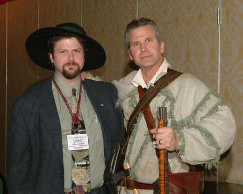
Here I am at the 2007 Pennsylvania Surveyor's Conference with Patrick Lee, who was there as a re-enactor performing biographical sketches told as Daniel Boone.

It was a thoroughly wonderful evening - Mr. Lee is a talented and enjoyable speaker. He has also graciously sent me several leads for researching one of my early Searcy ancestors, who was an associate of Daniel Boone's.


Technorati tags:
, , , ,

Pennsylvania Surveyors' Conference 2007

Posted by Dave Smith On 1/27/2007 10:20:00 AM 0 comments


I was able to enjoy some time at the Pennsylvania Society of Land Surveyors' 2007 Conference. It was great to see many old friends again, such as the great folks at PSLS that put the conference on, the Penn State Wilkes-Barre Surveying faculty (they have an excellent program there - I was fortunate to be able to tag along as an observer in the last ABET visit to Penn State, and have known Tom Seybert since my own days at Penn State as a student), as well as many fellow surveyors, PAMAGIC members, POBers and other folks - the conversation was great, I got a lot of input and thoughts on Continuing Professional Competency, data standards and geodesy, and many other things swirling around in my life of late.

My focus was to attend some of the GPS sessions, and though I was tied up with many other things, I was actually able to attend some, such as the "Horizontal Control Survey with GPS " session by GPS guru Dr. James P. Reilly, and the "Static GPS Post-Processing" session by Brian Naberezny, of PSU and University of Maine.

I also greatly enjoyed the excellent presentation put on by Patrick Lee, as a Daniel Boone re-enactor. As a pioneer in his westward movements, Daniel Boone was involved in surveying and land grants - and some of my own Searcy ancestors were colleagues of Boone, and were also surveyors in early Kentucky.

Patrick Lee as Daniel Boone


Technorati tags:
, , , , , , , , , , , , , , , , , , , , , , , , , , ,

"Longitude" - by Dava Sobel

Posted by Dave Smith On 1/15/2007 10:48:00 PM 0 comments

I just finished reading Longitude, by Dava Sobel. An enjoyable read, presented in a great anecdotal style, with plenty of colorful detail and insight into some of the joys and tribulations of John Harrison's attempt to conquer the challenge of accurate determination of longitude. Sobel lays out the background for the challenge, with tragedy at sea and other powerful driving forces, to include a challenge, with a virtual fortune ostensibly to be recieved by the winner...

The dynamic of battles between clockmakers and astronomers, and beyond this, the twists and turns introduced by the both arbitrary and capricious, yet bureaucratic and obstinate Board of Longitude are presented with great wit by Sobel, with our self-taught clockmaker protagonist, John Harrison showing tremendous brilliance and tenacity in the face of adversity after adversity.

A well written, well-researched, and extremely well-presented tale, if with odd continuity from chapter to chapter - I highly recommend it to anyone with an interest in science. Sobel spins an excellent tale, against a richly woven tapestry featuring many other great figures in 18th-century history, such as Astronomers Royal John Flamsteed, Edmond Halley, and Nevil Maskelyne, Captains Cook and Bligh, King George III and many others.

As fast as I read, the stack grows faster... Currently on the stack are re-reading Gödel, Escher, Bach, by Douglas R. Hofstadter, Drawing the Line: Tales of Maps and Cartocontroversy, by Mark Monmonier, I have Tales of the Dervishes by Idries Shah, Metamagical Themas (another Hofstadter book), The Geographer at Work, Mental Maps and a few others from my late Penn State professor Peter Gould and quite a few others working their way to the top of the stack...


Search