Surveying, Mapping and GIS

Exploring all aspects of mapping and geography, from field data collection, to mapping and analysis, to integration, applications development and enterprise architecture...

  • Geospatial Technology, End to End...

    Exploring all aspects of mapping and geography, from field data collection, to mapping and analysis, to integration, applications development, enterprise architecture and policy
Showing posts with label Google Earth. Show all posts

GeoServer

Posted by Dave Smith On 6/21/2008 11:16:00 AM 6 comments

The last few months have been hectic, with a lot of proposal writing and other things flying around - and as I continue to redefine and revisit and look toward new types of approaches and ways to tackle problems in architecting geospatial solutions, I have been making an effort to poke around and look at alternatives. Some of the major drivers for alternatives are licensing costs - Oracle is certainly not cheap - and the others are technical, finding fast and easy ways to publish and interact with geospatial data, provide interoperability and consume it in a wider variety of clients, e.g. OGC Web Map Service, KML, GeoRSS and the like...

So of late, I have been digging deeper with a stack consisting of PostGIS, GeoServer and GeoWebCache - and I must say I am impressed with what I'm seeing so far:
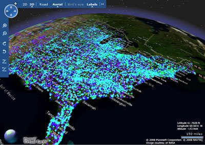


Here, hundreds of thousands of facilities points, being served up by PostGIS and GeoServer, and published as a tile layer in GeoWebCache. Firstly, the production ArcIMS/Oracle boxes I've been using would be struggling to render this much data quickly. Secondly, it would take a custom tile server or other middleware to get them into Virtual Earth - yet here I was able to get these results, start to finish, in less than an hour.

Same data in Google Earth as KML, again GeoServer provides some very interesting and compelling out-of-the-box functionality...

Again, the question I have been asking myself is in what the solution needs to look like - and here, we can have some hybridized approaches, depending on how static or dynamic the data is, and how much analysis we want to do, perhaps with products like GeoWebCache and GeoServer serving base data and tiles, and ArcGIS Server 9.3 providing modeling and analytical capabilities. This coming year will be interesting, to say the least...

Google Earth layers for Darfur

Posted by Dave Smith On 4/11/2007 04:40:00 PM 0 comments

To follow up, the full details of the Google Earth Darfur layers are available at the Holocaust Museum: http://www.ushmm.org/googleearth/

Google Earth exposes violence in Darfur

Posted by Dave Smith On 4/11/2007 03:37:00 PM 0 comments

It warms my heart to see that a headline story today is in how Google Earth has been working to expose the violence and bloodshed in Darfur.

This part of Sudan has been suffering horrendously in the midst of conflict, with denial from the Sudanese government - and thanks to the efforts of the folks at Google, the violence has been put front and center, with imagery depicting destroyed villages and lives, people displaced, and worse.

From one of the news articles,


Using high-resolution imagery, users can zoom into Darfur to view more than 1,600 damaged or destroyed villages, providing what the Holocaust Museum says is evidence of the genocide. Sudan's government denies that genocide is taking place.

In addition, the remnants of more than 100,000 homes, schools, mosques and other structures destroyed by janjaweed militia in Darfur, Sudanese forces and others are visible.

"
When it comes to responding to genocide, the world's record is terrible. We hope this important initiative with Google will make it that much harder for the world to ignore those who need us the most," said Holocaust Museum director Sara Bloomfield in a statement.

Ogle Earth carries some of the details: http://www.ogleearth.com/2007/04/darfur_webcast.html

As we saw with Rwanda, we cannot afford to sit by idly and do nothing.

From Reuters: http://www.reuters.com/article/internetNews/idUSN1043905220070410

From Associated Press: http://www.siliconvalley.com/latestheadlines/ci_5635344

PC Magazine: http://blogs.pcworld.com/staffblog/archives/004070.html

TechNewsWorld: http://www.technewsworld.com/story/56827.html


As an aside, as Google Earth has also been in the hot seat in the news of late, I recently was contacted by Kenneth Wong of Cadalyst Magazine "GIS Tech News" regarding the recent Google Earth controversy on Katrina.


I will certainly be one to defend Google Earth. As a federal contractor doing GIS work for Katrina response, we were long aware of their dedicated Katrina site, and to them I give kudos for providing infrastructure and imagery for the relief effort. Congressional inquiry? Not appropriate, and I certainly hope Google is spared this. However while I said "much to do about nothing" I also soundly will echo Adena Schutzberg's comment that it all the more points up the need for metadata for live data services and online mapping.

Portuguese Discovery of Australia?

Posted by Dave Smith On 4/02/2007 09:49:00 AM 2 comments

The Map Room blog has an interesting article discussing a reinterpretation of an old portolan chart found in a Los Angeles library vault, by author Peter Trickett. In his book Beyond Capricorn, Trickett argues the case for Portuguese discovery of Australia, long prior to the British or Dutch. According to Trickett, Portuguese explorer Christopher de Mendonca led a small fleet into Botany Bay in 1522, more than 200 years ahead of Captain Cook, and ahead of Dutch explorers as well.

Is it another Gavin Menzies adventure? The argument is rather compelling in some ways - obviously the chart describes a massive landmass, which does align well with parts of the Australian coast.

According to this MSNBC article, the map describes features one might expect in that region of Australia, however the coastline had some inconsistencies. It's argued that these inconsistencies may be either intentional and/or miscopied, including a 90° rotation along the coastline.

The Google Earth Hacks blog has a download, which overlays the map graphic (respliced with the 90° fix) atop the Australian landmass, so you can see this for yourself:


EPA Data and TerraIMS

Posted by Dave Smith On 3/12/2007 09:18:00 PM 0 comments

I don't always post about some of the things that we are working on, and perhaps I should do so more often.

I had some mixed feelings about recently seeing the Google Maps mashup that TerraIMS recently put up, showing EPA Superfund sites in proximity to a given address.
http://www.terraims.com/webservices/superfund.php


EPA has, for many years (in some instances, dating back to 1999), already had a number of community-oriented web mapping applications which deliver a great deal of information on EPA regulated sites, EPA cleanup activities, and so on - For example, one flagship of USEPA Office of Environmental Information is the venerable Window to My Environment - which, among other things, provides a great deal of information on EPA regulated facilities, watersheds, local and state resources, and the like at a community level. Window to My Environment currently gets well in excess of 50,000 hits per day.

Another excellent application which provides a lot of detailed information on environmental cleanup activity at a local level is the USEPA's Office of Solid Waste and Emergency Response (OSWER) Cleanups In My Community application.


These are just some of the web mapping projects that I have been involved in lately - there are actually several more EPA EnviroMapper applications available at the EnviroMapper StoreFront - and we are currently in the process of overhauling the core infrastructure of these, to migrate from legacy ASP/VBScript platforms to reusable component-based design, web services, and the ability to host some of these applications in an Oracle Portal environment, and integrating MetaCarta searches, among other things. We also have been doing some preliminary explorations in making EPA data available as KML for Google Earth, presenting some of our own Google Maps mashups (similar to TerraIMS), all of which are working wonderfully thus far. Unfortunately some of these enhancements are still in prototype, and others are only available on the EPA intranet.

So what of TerraIMS? Great work they did - but my concern isn't constrained, nor in any way specific to this particular mashup. The concern I have is with the description of the effort:

The U.S. Environmental Protection Agency recently released its National Priority list of Superfund Sites in XML format. We converted the XML data and integrated it with a database and then mashed things up a bit. Users enter an address and it is geocoded on the fly, enabling a distance query to be processed against the EPA data in the database. This mashup allows anyone to quickly and easily find the nearest Superfund Sites to their home address or a location of interest.

From this description, it sounds like they essentially have performed an extract of the EPA data, have massaged and processed it, and then do their mashup. The business case isn't tremendously compelling, as these maps and data are already long available, so it appears to be a mashup just for the sake of doing a mashup.

Fortunately Superfund data isn't tremendously volatile, however it nonetheless raises the question of other potential applications, of currency, completeness and accuracy of data utilized in mashups. Herein lies potential liability. If one uses a third-party mashup as a decision support tool, they would need to know to track back to the original source to ensure that the data they are viewing in the mashup is current, complete, and accurate...

Never know what you might discover...

Posted by Dave Smith On 3/03/2007 10:14:00 PM 2 comments

I have to admit, I am a Google Earth junkie, and as a technocrat, I have multiple machines at my desk. When one is going to be sitting semi-idle or running background tasks for any period of time, I sometimes fire up Google Earth on it, zoom in to a low altitude, put a slight angle tilt on the view, and set it at a lazy drift over some semi-randomly selected countryside.

Periodically, I will stop and sit in amazement at some of the scenery. Ancient ruins, meteor craters, breathtaking landscapes... the lunar landscape of the Libyan desert, you name it. I also periodically check out the goodies that sites like Google Earth Hacks have, as well as some of the other sites that track not just Google Earth, but other sites featuring imagery.

Google Karten tracks Google Maps, and picked up one of the more amazing things I've seen in a while... A cruise missile, captured in-flight over Utah...

Search