Surveying, Mapping and GIS

Exploring all aspects of mapping and geography, from field data collection, to mapping and analysis, to integration, applications development and enterprise architecture...

  • Geospatial Technology, End to End...

    Exploring all aspects of mapping and geography, from field data collection, to mapping and analysis, to integration, applications development, enterprise architecture and policy
Showing posts with label OpenStreetMap. Show all posts

ESRI and Volunteered Geographic Information

Posted by Dave Smith On 2/20/2010 10:36:00 AM 7 comments

Once again, I greatly enjoyed this year's ESRI Federal User Conference - I was able to make it to several sessions Thursday and Friday... Perhaps will post more on this, as time permits.


As he has done before, Jack Dangermond solicited feedback and questions in his FedUC wrapup following Recovery Accountability and Transparency Board chairman Earl E. Devaney's excellent talk - I was happy to pitch in and asked him my own question about ESRI's vision for volunteered geographic information / crowdsourcing / participatory GIS...

This got Jack Dangermond excited, it seems he has been thinking about the concept, though even with his response, we need to get beyond the initial technical hurdles - and in talking to some other ESRI folks during and after the conference, I am happy to hear that some other ESRI staffers are thinking about this as well.

The thing is this: It's not really about ESRI tools importing OpenStreetMap, GeoRSS or Twitter feeds, and so on. Mere import and merge with your own data is really just a tiny part of it.

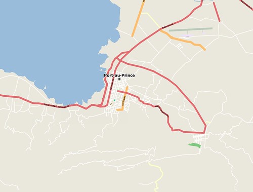
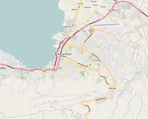
The true power of VGI is in its dynamic nature - for example, in the case of Haiti response, there were dozens of volunteers all providing concurrent updates, imports and edits to OpenStreetMap, as well as hundreds consuming the map data. The state of the map changed, sometimes radically, from hour to hour, and often even from minute to minute. As one example, an individual on the ground in Haiti sent an SMS message to Ushahidi with GPS coordinates for two locales where supplies could be airdropped or landed via improvised helicopter landing zone. The maps were blank in those two areas. Yet, within minutes, I and other OSM mappers pulled up the declassified DMA maps, DigitalGlobe and other imagery that had been donated by various providers, and sketched in the roads, trails, streams, buildings and other culture and planimetrics for those communities in need.

Leveraging those dynamic updates is one key piece to making the most of VGI. That means, going beyond import, to being able to consume and integrate the data on the fly.

The second piece is that VGI is not a one-way street. To use Haiti again as an example, dozens of disparate agencies are all using OpenStreetMap - several are in turn actively contributing back as well. Each is then building up on the work of the others, and the efforts of each resource leverages successive investments of the prior effort. This is particularly useful for resource-constrained organizations and volunteer efforts. As an example of this, as a member of Engineers Without Borders, I have been trying to promote adoption of OpenStreetMap for mapping efforts - e.g. one effort providing potable water can then dovetail into another organization's efforts to do health assessments, and so on.

As to cultural and organizational resistance to crowdsourcing, accuracy and reliability - that can be handled via record-level metadata. The double-edged sword of OpenStreetMap is in its use of key/value pairs for attribute data, as opposed to rigidly structured tables and columns, which on one hand can lead to folksonomies with inconsistent tagging, but on the other hand can handle rapid, flexible, ad-hoc changes to accomodate new needs, as well as allow complex representations via a collection of tags - which in turn can then also be cross-walked to other agencies' data models for interaction and ETL. While OpenStreetMap, on its' face, leaves much up to the individual contributors, best practices can and should be implemented. All edits are tracked in OpenStreetMap, which provides some basic metadata as to who and when, however more robust means of reverting adverse changes would be useful. Similarly, best practices are generally communicated via wiki, such as adding tags for source (e.g. digitized from DigitalGlobe imagery, with date). One of my comments in my followup to Jack Dangermond was that some of the governance/user guidance can be put directly into the tools, such as via JOSM, Merkaartor or Potlatch presets and templates.

Some may push back and suggest that shared community platforms like OpenStreetMap lack accuracy or reliability. The beauty of it is that if you don't like it, you can fix it.

And another goal... Dynamic integration of community platforms like OpenStreetMap beyond just base mapping and visualization, to be incorporated into modeling and analysis, via crosswalks and semantic interoperability.

I am happy to see this is something of interest to Jack Dangermond and ESRI, and hope that the bidirectionality and dynamic nature of VGI are fully embraced down the road.

Mapping for Haiti Earthquake Response

Posted by Dave Smith On 1/18/2010 04:30:00 PM 2 comments


For the last few days I have been working on efforts to help Haiti earthquake response - part of this is mapping Haiti via OpenStreetMap. Currently, useful maps of Haiti are few and far between, in some case there are detailed maps for parts of the country and cities like Jacmel, but which are print maps (no digital edition exists), in many cases many decades old and outdated, in other instances the only maps which exist are small-scale, with limited detail. Commercial map platforms like Bing Maps, Google Maps and Yahoo vary greatly in their detail as well, and update cycles are slow - however, here, OpenStreetMap has been able to rapidly respond and provide very speedy and robust updates, to include capturing data about collapsed buildings, and so on.

Mikel Maron captures the speed and effectiveness of OpenStreetMap with these two screenshots of Port-Au-Prince, just before the earthquake and just after:

before:


after:


I would encourage any others who have time to contribute to get involved in this effort as well - editing can be done directly in OpenStreetMap via the 'edit' tab, which opens a web-based tool called Potlatch - or, a number of other tools are available as well. (You will need to register an account in order to edit - feel free to connect with me there as well - http://www.openstreetmap.org/user/Dave%20Smith). The OpenStreetMap WikiProject Haiti page provides a lot of good information and frequent updates. A number of data sources have been assembled, together with fresh post-earthquake imagery generously donated by companies like DigitalGlobe.

For folks who are interested in more robust tools, I primarily use Merkaartor which runs best on Windows platforms - others favor JOSM which is Java-based and runs on any platform supporting Java.

With either of these, you should be able to use the download function to navigate to an area of Haiti (select a relatively small area) and then download the OSM data

Some have wrestled with getting the various available imagery and map services to work properly in JOSM and Merkaartor - they are both a bit clunky about accessing WMS servers - I can offer some of my tips gleaned from a little debugging using Fiddler2: For Merkaartor, use Tools -> WMS Servers Editor and create a new entry with the following URL: http://maps.geography.uc.edu/cgi-bin/mapserv?map=/home/cgn/public_html/maps/mapfiles/haiti.map&version=1.1.0&SERVICE=WMS&REQUEST=GetMap? and show capabilities to access the DigitalGlobe CrisisEvent imagery (DG_crisis_event_service), select EPSG:4326 (only option available) and image/png and you should be able to go from there. If there is no image layer showing, go to Layers -> Add new image layer, and then right-click on the newly added image layer and select your newly-added WMS server for DigitalGlobe.

Digitization tasks are fairly intuitive - tools allow you to draw points, lines and polygons, as well as to create relations which allow multiple entities to be grouped together - however the absolute key to success is in proper use of tags to provide attribute values for any entities being created. These are generally intuitive as well, e.g. tag of highway, value of residential to turn a generic line into a residential road. It also helps to look at tagging of existing features, and to familiarize yourself with the features list - the OpenStreetMap wiki is searchable and quite useful. Finally, as terms of using the DigitalGlobe imagery, any data entered using their imagery should also be tagged with source=digitalglobe.

One of the other projects I have been working on is development of a set of tags that would be useful for emergency responders, relief and aid efforts - for this, I have started a wiki page http://wiki.openstreetmap.org/index.php?title=Humanitarian_OSM_Tags- any comments and thoughts can be added to the wiki page.


--- Update: Jan 20 ---

To update, I wanted to also include reference to the video tutorial that Kate Chapman put together on mapping for Haiti, to help demystify the tools:


Thanks to Kate and all the other great folks contributing to the Haiti mapping efforts...

OpenStreetMap

Posted by Dave Smith On 11/27/2009 10:20:00 PM 3 comments


Recently one of my little side pursuits has been playing with OpenStreetMap. I had tinkered with it a little bit some time ago, and decided to revisit it.


For those who have not yet looked at OpenStreetMap, it is an open mapping framework, which utilizes public domain and crowdsourced data: http://www.openstreetmap.org/

Currently, there are a number of excellent tools available for working with OSM, such as the Potlatch web editing environment (within OSM, click on the 'edit' tab and away you go - it provides basic tools for adding points of interest, moving and deleting items, and adding attributes to existing points...

For a quick start, help information is available via a wiki here: http://wiki.openstreetmap.org/wiki/Main_Page

With regard to other tools for editing OSM, I've been using Merkaartor in a Windows environment - http://www.merkaartor.org/ - several other users use a Java tool, JOSM - http://josm.openstreetmap.de/ - they both appear to have comparable feature sets.

Potlatch also provides some basic aerial photos, however Merkaartor and JOSM also allow users to work with WMS services, ESRI shapefiles and other sources of data toward fast digitization and capture of data.

On committing editing changes, new tiles are rendered rather quickly, allowing OSM to allow rapid development of base maps. Many people are also using GPS for track logs, which can then be uploaded to OSM as GPX to facilitate capture of trails and unmapped streets.

In many places, OSM is being used to create maps where there previously were none, such as in developing countries - this might serve efforts such as Engineers Without Borders - and I plan to revisit some of the GIS data I've collected up for places like Cameroon and Rwanda on behalf of EWB and look at getting it posted to OSM where appropriate.

Locally, I have been playing with the mapping for my own town - I found that it essentially just had some older TIGER data and Points of Interest (POIs) from USGS Geonames (GNIS). The road network came up jagged and inaccurate, many features missing, outdated and so on. Here's where local knowledge and feet on the ground comes into play in crowdsourcing.

I essentially started out with something that looks like this:
And have quickly been going to something that looks like this:
Here, I've been using orthophoto WMS services and other datasets for correcting streets and railroads, digitizing streams, putting in building footprints, parks, trails and amenities, and in just a short time am rapidly going to a useful and reasonably attractive map (note that this is still in progress). Further, the data can also be reused in a variety of ways, such as in Open Source routing services, using custom styling and symbology and so on.

I would highly encourage others to take a look and play with it: http://www.openstreetmap.org/ - however, with the caveat that it can be addicting...

Search