 Last week, I attended a discussion session sponsored by the Pennsylvania Mapping and GIS Consortium (PaMAGIC) and facilitated by John Palatiello, regarding standing up a Geospatial Coordination Council as a formal governmental advisory body for Pennsylvania. This is not a new concept, it is something that PaMAGIC has been pursuing for several years, it has been discussed several times prior at the PA GIS Conference, and has been introduced in the legislature several times, in various incarnations. It was last introduced in 2007-2008 by Representative Russ Fairchild as House Bill 1304.
The discussion session was held at the Pennsylvania State Association of Township Supervisors' office just outside Harrisburg, and roughly 60 people attended in person and by phone - an excellent cross section of state government, county and local government, private sector, utilities and others. I did not, however, see any representation by the Pennsylvania Society of Land Surveyors or Pennsylvania Society of Professional Engineers. Similarly, I do not see a spot designated on the proposed Council for these organizations.
I have posted two documents - one is a summary of the meeting, the second is the newest version of the proposed bill - the GIS community is invited to provide comment, by the end of this week, to PaMAGIC President Glenn McNichol, gmcnichol -at- dvrpc.org.
Pennsylvania Geospatial Coordination Council
Mapping for Haiti Earthquake Response
![]()
For the last few days I have been working on efforts to help Haiti earthquake response - part of this is mapping Haiti via OpenStreetMap. Currently, useful maps of Haiti are few and far between, in some case there are detailed maps for parts of the country and cities like Jacmel, but which are print maps (no digital edition exists), in many cases many decades old and outdated, in other instances the only maps which exist are small-scale, with limited detail. Commercial map platforms like Bing Maps, Google Maps and Yahoo vary greatly in their detail as well, and update cycles are slow - however, here, OpenStreetMap has been able to rapidly respond and provide very speedy and robust updates, to include capturing data about collapsed buildings, and so on.
Mikel Maron captures the speed and effectiveness of OpenStreetMap with these two screenshots of Port-Au-Prince, just before the earthquake and just after:
before: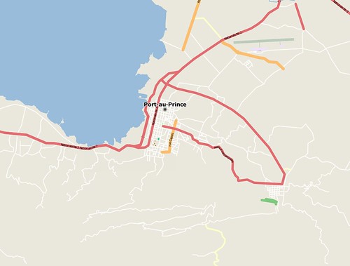
after: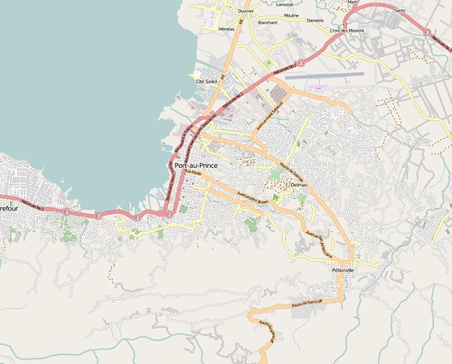
I would encourage any others who have time to contribute to get involved in this effort as well - editing can be done directly in OpenStreetMap via the 'edit' tab, which opens a web-based tool called Potlatch - or, a number of other tools are available as well. (You will need to register an account in order to edit - feel free to connect with me there as well - http://www.openstreetmap.org/user/Dave%20Smith). The OpenStreetMap WikiProject Haiti page provides a lot of good information and frequent updates. A number of data sources have been assembled, together with fresh post-earthquake imagery generously donated by companies like DigitalGlobe.
For folks who are interested in more robust tools, I primarily use Merkaartor which runs best on Windows platforms - others favor JOSM which is Java-based and runs on any platform supporting Java.
With either of these, you should be able to use the download function to navigate to an area of Haiti (select a relatively small area) and then download the OSM data
Some have wrestled with getting the various available imagery and map services to work properly in JOSM and Merkaartor - they are both a bit clunky about accessing WMS servers - I can offer some of my tips gleaned from a little debugging using Fiddler2: For Merkaartor, use Tools -> WMS Servers Editor and create a new entry with the following URL: http://maps.geography.uc.edu/cgi-bin/mapserv?map=/home/cgn/public_html/maps/mapfiles/haiti.map&version=1.1.0&SERVICE=WMS&REQUEST=GetMap? and show capabilities to access the DigitalGlobe CrisisEvent imagery (DG_crisis_event_service), select EPSG:4326 (only option available) and image/png and you should be able to go from there. If there is no image layer showing, go to Layers -> Add new image layer, and then right-click on the newly added image layer and select your newly-added WMS server for DigitalGlobe.
Digitization tasks are fairly intuitive - tools allow you to draw points, lines and polygons, as well as to create relations which allow multiple entities to be grouped together - however the absolute key to success is in proper use of tags to provide attribute values for any entities being created. These are generally intuitive as well, e.g. tag of highway, value of residential to turn a generic line into a residential road. It also helps to look at tagging of existing features, and to familiarize yourself with the features list - the OpenStreetMap wiki is searchable and quite useful. Finally, as terms of using the DigitalGlobe imagery, any data entered using their imagery should also be tagged with source=digitalglobe.
One of the other projects I have been working on is development of a set of tags that would be useful for emergency responders, relief and aid efforts - for this, I have started a wiki page http://wiki.openstreetmap.org/index.php?title=Humanitarian_OSM_Tags- any comments and thoughts can be added to the wiki page.
Thanks to Kate and all the other great folks contributing to the Haiti mapping efforts...
The "Antiquated" County Surveyor?
 In Pennsylvania, the position of County Surveyor was abolished decades ago. Elsewhere, some states do still have County Surveyors - yet where still in use, it has in some instances become politicized, or may have duties which are either murky, inconsistent from one place to another, or even a position without any duties. Many consider the position "antiquated".
 Here, the County Surveyor could be responsible for reviewing submitted plans, for working with other local surveyors toward getting surveyed parcels, subdivisions, rights-of-ways and so on tied to a consistent system of monumentation, via GPS and other means, and so on, tying deeds and land records data to GIS data - toward iteratively refining the cadastre toward providing ever-increasing degrees of accuracy and reliability. Similarly, the County Surveyor could work with his counterparts in adjoining counties collaboratively toward building and bolstering regional, and ultimately statewide partnerships such as PAMAP here in Pennsylvania, which was a collaborative effort toward leveraging investments for obtaining aerial imagery - similar approaches can be taken toward gathering a host of other core datasets and mapping, such as LIDAR data, hydrology, roads, utilities, buildings and structures, and so on.

