Happy New Year!

Old gives birth to new...
A lot of good things going on, many irons in the fire, and many interesting prospects on the horizon... I am looking forward to 2008...
Wishing a good year to everyone!
A lot of good things going on, many irons in the fire, and many interesting prospects on the horizon... I am looking forward to 2008...
Wishing a good year to everyone!


![]()
 As reported by some news outlets, Lakota activists have sent a letter to the US State Department announcing their intention to secede from the United States.

Came across this interesting hack for the HTC TyTn II / AT&T Tilt:
With a registry editor, open HKEY_LOCAL_MACHINE\SOFTWARE\HTC\Camera\ - and in folder called P9, change the value "enabled"from 0 to 1.
And, voila:
 You now have an additional option button to select GPS Camera, and now your lat/long will be grabbed automagically from the integrated GPS to be embedded in the photo's EXIF tag.
Now if only I can find a hack for the camera's lag...
After hearing some recent trials and tribulations of a surveyor arguing a legal lot line adjustment with the county GIS department (same story repeated again and again all across the nation), it again underscores the issue of what is or isn't cadastral GIS.
In Pennsylvania, our State Law says, “Practice of Land Surveying” means the practice of that branch of the profession of engineering which involves the location, relocation, establishment, reestablishment or retracement of any property line or boundary of any parcel of land or any road right-ofway, easement or alignment; the use of principles of land surveying, determination of the position of any monument or reference point which marks a property line boundary, or corner setting, resetting or replacing any such monument or individual point including the writing of deed descriptions; procuring or offering to procure land surveying work for himself or others; managing or conducting as managers, proprietors or agent any place of business from which land surveying work is solicited, performed, or practiced; the performance of the foregoing acts and services being prohibited to persons who are not granted certificates of registration under this act as a professional land surveyor unless exempt under other provisions of this act.
As such, what exactly does a tax map represent? It seems that many GIS departments hop back and forth between boxes, either arguing that it is not surveying, and only deals with a schematic showing taxation, but at the same time, argue issues of deeds and possession, enter their parcel boundaries using COGO, and so on.
Either it is, or it isn't. If it is indeed a representation of the cadastre - and after all, taxation is uniquely tied back to the parcels and their possession - then it needs to be properly treated as such. If, on the other hand, it's not a representation of the cadastre, then perhaps it's in fact something which perhaps has no real meaning, merit or legal standing whatsoever.
If the former is the case, then it likely needs to be getting developed and maintained under the purview of a licensed professional land surveyor, per state law - if the latter is the case, then I believe the whole process needs to be re-evaluated.
I'll put this out there for debate, with the caveat that I did intend to stir the pot - I'm interested in getting others' earnest perspectives.
Seems a post on All Points Blog regarding NeoGeography has unleashed a flurry of posts relating to "paleo" versus neo and a whole lot of other issues.
I think I have a slightly different of a take on it... I view the two as sort of a Venn diagram, with each representing expanding spheres, with an equally expanding area of overlap and merging between them.
Note, my little 5-minute Visio diagram is not by any means intended to be comprehensive... But the fuzziness and overlap is fully intended.
I do not view them as "in competition" - each has its own stakeholders and requirements, and between the two there is a considerable area of commonality. The exciting thing about neogeography, however, is that it's about empowerment and putting tools and capabilities into the hands of the public, which previously would have been inaccessible. Additionally, it's about fusion and collaboration - which benefits both communities.
And along the whole NeoGeo theme, I will leave with this:
We're looking for a senior GIS architect to help head up GIS applications development and enterprise architecture efforts on a federal program:
GIS Project Manager - (US-VA-Arlington)
Min Education: Bachelors
Job Type: Full Time Employee
Industry Job Title: Geographic/Geospatial Information Systems (GIS) Project Manager
Required Skills:
1. Strong people skills.
2. Excellent writing and briefing skills including good command of grammar and business communications style before groups or one-on-one, i.e., the ability to convey ideas clearly and concisely in non-technical terms.
3. A solid record of accomplishment in the planning, design, and management of integrated and open enterprise GIS operations on a national scope, employing Oracle Spatial and ESRI environments.
4. Must be able to define the scope, direction and advancement of GIS operations on the behalf of the customer.
5. Must have expert knowledge in geospatial data creation best practices.
6. Have familiarity with land surveying principles and practices.
7. Must be able to manage and cultivation a team of GIS professionals, specialists and technicians, within a heavily integrated data service and GIS application environment.
8. Must be able to oversee the development of GIS applications to improve efficiency and effectiveness in applicable areas of GIS operations related to customer needs.
9. Requires familiarity with developing web applications in Java and Oracle Application Server that operate in an ESRI environment within the services oriented architecture.
10. Must demonstrate an ability to conceptualize and develop enterprise GIS systems, and lead multi-disciplinary teams and personnel in implementing geospatial systems.
11. Must have in-depth knowledge of enterprise and application life cycles and current awareness of trends and practices in GIS technology.
Desired skills:
1. Knowledge and understanding of the Environmental Protection Agency (EPA) mission and/or actual work experience in supporting the EPA in GIS technology.
2. Working Knowledge in the following software and technology concepts:
• GIS database design
• GIS application design
• Oracle RDBMS environments.
• Oracle Spatial 9i and 10g.
• ArcGIS 9.x desktop clients
• Microsoft Virtual Earth/API
• ArcWeb Services
• ArcIMS 9.x
• ArcObjects
• PL/SQL
• Fusion Middleware
• GPS/mobile GIS computing
• GeoRSS
• ArcSDE/ArcGIS Server 9.x,
• GIS system architecture design strategies.
• OGC and open GIS data architecture standards
• FGDC CSDGM
Specific Job Description:
Directs all phases of GIS programs from inception through completion. Responsible for coordinating subordinate employee recruitment, selection and training, performance assessment, work assignments, salary, and recognition/disciplinary actions. Responsible for the cost, schedule and technical performance of GIS programs. Coordinates the preparation of proposals, business plans, proposal work statements and specifications and operating budgets for GIS activities. Acts as primary customer contact for GIS program activities, leading GIS program review sessions with customer to discuss cost, schedule, and technical performance. Establishes GIS design concepts, criteria and engineering efforts for product research, development, integration and test. Develops new GIS business or expands the product line with the customer. Establishes milestones and monitors adherence to master plans and schedules. Identifies GIS program problems and obtains solutions.
Security Clearance: Applicant must be able to pass SF-85P Public Trust
Typical Minimums:
Bachelor’s degree from an accredited college in geographic information systems or a related field such as engineering, geography, computer science, planning, mathematics or applied science, or equivalent experience/combined education, with 10 years of professional experience; or 8 years of professional experience with a related Masters degree. Considered an emerging authority.
Place of Performance: On-site, Arlington VA
Applying:
Applicant must be a US Citizen or have US Permanent Resident Status
Interested applicants should respond with a current curriculum vitae and salary requirements to dsmith[@]synergist-tech.comSynergist Technology Group, Inc. is a Service Disabled Veteran Owned Small Business, specializing in GIS, Environmental Science, Intelligent Transportation Systems and Systems Engineering.
We are also currently looking for an authority on Documentum as well.
I recently learned that the Virtual Earth vector generalization issue that I discovered earlier to has at least been partly remedied in a fix that Microsoft recently rolled out, by allowing developers to turn it off:
From this (note the significant gaps and overlaps):
 To this:
 Gaps and overlaps no longer occur, and polygons are now true to the source KML.
This just came out as a fix issued November 16, and is implemented via a VEMap method: map.EnableShapeDisplayThreshold(false); However, I noted that the VE team still needs to fix the generalization algorithm that’s still being implemented by default or when map.EnableShapeDisplayThreshold is set to true.
One of my colleagues has however reported that he's still seeing some generalization issues in GeoRSS at some zoom levels despite the display threshold setting.
Per a forum post by the VE developer team (note that it also includes some other recently announced enhancements as well):
The Virtual Earth v6 API has been updated. The below list is not comprehensive. However, it talks about the bugs that has been dicussed on the forums.
Bug Fixes:
New Features/Functionality:
Code Block
var spec = new VEShapeSourceSpecification(VEDataType.ImportXML, http://enteryourkmlurlhere.htm");
map.ImportShapeLayerData(spec);
Code Block
var options = new VERouteOptions();
options.UseMWS = true;
map.GetDirections(['redmond,wa','seattle,wa'],options);
//The UseMWS flag uses the MapPoint Web Service routing engine which provides localized
results. However, the generated route might be slightly different from the default routing engine’s route.
Code Block
map.EnableShapeDisplayThreshold(false);
To Be Fixed/Updated:
Not Fixed:
Code Block
map2 = new VEMap('myMap2');
map2.LoadMap();
map1 = new
VEMap('myMap1');
map1.LoadMap();
Code Block
//This code is only nessecary for v5 mapcontrol when in 3D mode
//However, This will not work for when -3.142 < lat < -3.142 = 180 e.latLong.Longitude <= -180 e.latLong.Longitude >= 180))
{
//Convert latlong to a valid latlong
var r2d = 180.0 / Math.PI;
e.latLong = new
VELatLong(e.latLong.Latitude / r2d, e.latLong.Longitude / r2d);
}
Along the historic maps vein, another ancient map receiving a lot of press of late is the Tabula Peutingeriana - this one I find tremendously fascinating, being a view of the Roman world of nearly 2000 years ago. As a kid, I grew up in Germany, near Roman ruins of the Limes Germanicus and other features, and as such, I have always been fascinated with all things ancient.
Presently, the Tabula Peutingeriana is being added to the UNESCO Memory of the World Register as an important artifact, and, given its extreme fragility, was recently placed on public display for one day in Vienna on November 26th.
The Tabula Peutingeriana is a copy of a Roman cursus publicus, which was a schematic roadmap of roads, cities and other features as developed and used in the Roman Empire. There are no longer any known copies of the original Roman cursus publicus charts, however the Tabula Peutingeriana is believed to have been transcribed from an original one by a thirteenth-century monk in Colmar, and consists of a number of sheets with schematic diagrams showing stops along routes, very similar to a modern-day subway map.![]()
As such, it displaces many features to fit the route rather than attempting to be cartographically correct, and as such, it does not represent latitude and longitude in a conventional sense - instead accomodating the routes and features along them first and foremost, resulting in a very long, skinny map generally oriented west to east.
The geographic extent of the map is staggering, spanning the British Isles to India and Sri Lanka, showing what would have been trade and military routes, the infrastructure and cultural exchange that would have gone on in Roman times.
One of the things that I was playing around with over the weekend is trying to match up features as shown on the Tabula Peutingeriana to modern features - one of the tools I was playing around with is Microsoft Research's MapCruncher for Virtual Earth:
While I wouldn't expect MapCruncher to be able to rubbersheet a schematic map such as the Tabula Peutingeriana to a conventional map, it has nonetheless given me many insights just in being able to match up ancient designations and routes to their modern counterparts in a managed fashion, and it has made for a fun rainy (or snowy, as the case may be) day project.
Reuters is carrying a story about the preservation of the 1507 Martin Waldseemüller World map, the first known to refer to the New World as America.

Some of the individuals cited in the article express their puzzlement at how Waldseemüller was able to portray as much detail and accuracy as he did, given the extremely limited amound of knowledge that is generally believed to have been extant regarding the New World at this time - for example, Vasco Núñez De Balboa had not crossed the Isthmus of Panama to reach the Pacific until 1513, and likewise, Magellan had not rounded the southern tip of South America until 1520, yet these are shown.
Interestingly, many features in this map are reversed in subsequent maps by Waldseemüller.
The map is cited in the article as a 'keystone map', showing a fundamental shift in how Europe viewed the New World. It also raises many questions about how much we really understand geographic awareness and the availability of cartographic information in ancient times.
My own notion is that we sometimes do not give our predecessors enough credit for their knowledge of the world around them.
I finally got around to upgrading my mobile platform. I had been toting around my Motorola cellphone, iPaq, Holux GPSlim 240 bluetooth GPS, and all of the associated iGo tips and other associated cables...
I looked at a number of units, Blackberries, Treos, Nokia N95 (very nice), along with the Samsung BlackJack (BlackJack II coming soon), Motorola MotoQ and others - but ultimately narrowed things down to Windows Mobile, as I have a lot of software for that platform (ArcPad, navigation, et cetera) - and Windows Mobile can run your selection of Java VM as well - best of both worlds.
Yesterday, I ended up getting the HTC TyTn II (also known as AT&T Tilt and by a few other names) - and I'm pretty happy with it thus far. It's the only Windows Mobile unit that I came across to feature BlueTooth, WiFi, 3G Data, and integrated GPS. It also has a 3 megapixel camera to boot.
I'm still looking to pick up a nice big MicroSD card, so I haven't yet loaded it up with a lot of stuff, but I have been playing with Google Maps Mobile, Microsoft Live Search Mobile (Virtual Earth), and Mobile GMaps on the Esmertec JBed JVM that ships already installed on the HTC unit. Notably, when I went to Esmertec's site, I was greeted with an Android info page, so I may be looking at gPhone apps as well.
Pretty nice, so far! I am looking forward to developing some things that take advantage of this new platform...

Captain John Smith's map of New England, dated 1614.
The map was probably drawn by Simon van der Passe, the son of a Dutch engraver, based on one drawn by John Smith. It is very similar to an earlier version which omitted the "New" which prefaces "Plimouth," and does not include Salem. The English colonists who settled in Plymouth in 1620 almost certainly had access to this map. In his Advertisements for the Unexperienced Planters of New England, or Any Where (London, 1631), Smith commented wryly: "Now since them called Brownists went, some few before them also having my bookes and maps, presumed they knew as much as they desired . . . " (The Complete Works of Captain John Smith (1580-1631), ed. by Philip L. Barbour (Univ. Of North Carolina Press, 1986), vol. 3, p. 285.
Reprinted in Deetz and Deetz, The Times of Their Lives, p. 70.
Also featured in this map archive is the following:

The only known map of the town layout, as drawn by William Bradford in 1620. From the site,
William Bradford's sketch of the town of Plymouth.
The Bradford sketch, entitled "The meersteads & garden plots of which came first layed out 1620" is the only known map of the original town layout. The sketch is bound into the front of a manuscript volume entitled "Plimouths Great Book of Deeds of Lands Enrolled from Ano 1627 to Ano 1651." The first part of the volume is in the handwriting of Governor William Bradford, as is the map. The volume now comprises Vol. 12 , Deeds, &c. Vol. 1 1620-1651 of The Records of the Colony of New Plymouth in New England, edited by Nathaniel B. Shurtleff and David Pulsifer (William White, 1855-61; AMS Press, 1968).
John A. Goodwin, in his The Pilgrim Republic (Boston: Houghton Mifflin, 1920; Kraus reprint 1970), has extended the plan to include his interpretation of the position of occupants on the north side of the street, and of the street in relation to the harbor and the fort.
The original Bradford sketch is reprinted in Deetz and Deetz, The Times of Their Lives, p. 66.
Finally, from Wikipedia's entry on the Plymouth Colony, a map showing the geographic extent of the Plymouth Colony:
Posting live from EPA's Environmental Symposium in St. Louis - One of the things that's being discussed there is a challenge put forth by Bill Ruckelshaus, former EPA Administrator, who is now heading up the Puget Sound Initiative, to clean up this natural resource that forms a big part of Northwest Washington State.
As part of this, they established a wiki, and are having mashup camps to rapidly get as much content relating to Puget Sound and its' environment as possible:
In a few short hours, I was able to develop a Virtual Earth mashup, which performs MetaCarta searches against EPA and other federal and state documents, pulls in EPA Toxic Release Inventory for Washington State as a KML layer, WMS layers for USGS Wetlands and Land Cover (NLCD), as well as NHD layers showing streams and impaired waters.
There is also a great OpenLayers-based mashup builder and other tools - anyone interested in improving the environment in the Puget Sound area will be encouraged to participate as things move forward.
I also built a standalone version here: http://www.synergist-tech.com/Demo1/PugetSound.html

Synergist Technology Group, Inc. is currently looking for GIS web applications developers, for its Pennsylvania and Northern Virginia locations.
Requirements:
Strong background in web-based GIS applications development.Desired Skills:
- DHTML, CSS, and JavaScript;
- ASP.NET, C#, VB.NET, or Java
- ESRI ArcIMS
- Web Services (XML, SOAP, JSON, REST, OGC)
- Understanding of spatial databases
ArcGIS Server, Oracle Spatial query and analysis, mashups and exposure to Microsoft Virtual Earth, Google Earth, Google Maps, good documentation and communication skills.
Additionally, a background in emergency response, transportation, facilities management or environmental science may be very useful.
Applying:
Applicant must be a US Citizen or have US Permanent Resident Status
Interested applicants should respond with a current curriculum vitae and salary requirements to dsmith[@]synergist-tech.com.
Synergist Technology Group, Inc. - A Service-Disabled Veteran-Owned Small Business (SDVOSB) specializing in geospatial technology, environmental science, transportation and emergency response.
It's been a very busy few weeks, so I haven't had much chance to post... things going on with Virtual Earth, ArcIMS Route Server and GDT/TeleAtlas, survey-grade GPS data collection, emergency response, logistics, modeling and simulation, and plenty of other things flying around.
It's all fun stuff, but I always enjoy rolling the sleeves up and getting dirty... doing the AJAX thing, mashing various web services with Virtual Earth's V5 API via pure JavaScript clients as various proof-of-concept applications.
Here's one quick app: Virtual Earth and the NASA MODIS WMS server: Here I'm showing the VE and MODIS side-by-side, both views refresh dynamically. The next step will be to explore the "Roll Your Own Tile Server" approach to seamlessly getting custom WMS content directly into VE.
The next one was even more fun: Virtual Earth and the MetaCarta JSON API: All pure Web 2.0, neogeo, slippy AJAXIAN goodness, "Look, Ma! No "SUBMIT" button!!" Type in your query, (searching for documents about toxic substances here...) and it fetches results from the MetaCarta appliance and sprays them back into the VE map view. Pan, zoom, and instantly you get new stuff popping up. All self-contained in a few k of DHTML, CSS and JavaScript, no Java, .NET, Ruby, Python or other infrastructure needed. Both written in a total of about 2.5 hours, just noodling around in the APIs without any real thought ahead of time.
A friend found this:
Simple, silly, prankish, but gave me a much needed chuckle...
 From a memo circulated by USEPA CIO and AA for USEPA's Office of Environmental Information (OEI), Molly O'Neill:
I am very pleased to announce and welcome Jerry L. Johnston, Ph.D as the new Geospatial Information Officer (GIO) for EPA. Jerry has many years of geospatial experience in a variety of public and private sector positions. Most recently, he was a manager in the Environmental Fate and Effects Division in the EPA Office of Pesticide Programs where he successfully integrated geospatial analysis into the regulatory assessment processes of OPPTS. Prior to joining EPA, Jerry was in private industry where he held numerous roles including that of a Chief Technology Officer.Congratulations to Mr. Johnston. This will be a challenging, key role in the agency moving forward, for governance, best practices, data stewardship, enterprise architecture, SOA, OMB GeoLoB and so on.
Over the course of his distinguished career, Jerry has demonstrated an exceptional ability to apply geospatial technology to help solve complex environmental problems. His understanding of information technology, policy development, geospatial data, and the business processes of EPA will be invaluable as we develop new approaches for managing and using environmental information.
I have mentioned to several people that I believe our geospatial work is just beginning and there are great opportunities ahead. Jerry's experience, energy, and fresh perspective will be important to leading this effort and I am confident that he will work collaboratively with the entire GIS community at EPA to make huge strides.
Jerry will be joining us full-time in mid-July. Please join me in welcoming Jerry to OEI!
 Yesterday, I was offered an iPhone, out of the blue. Yea, it's really cool, has an incredible interface, is power-packed with features, and just amazing technological innovations. But... I remain skeptical, I just don't share the enthusiasm that Peter Batty and others are demonstrating. Just a few things I have found thus far:
 I was amazed to see the articles in the news about the border fence debacle, where construction evidently went full-tilt along the US-Mexico border to construct a fence to prevent illegal immigration, following 120-year-old barbed wire strands, and without any apparent proper surveying research, and construction stakeout.

There have been a number of news stories circulating about the H1B visas and overseas technology workers finding employment in the US:
A fraud aspect of it stems from the appearance that employers are going out of their way to deny Americans jobs - more details here:
There are a number of additional videos and clips on YouTube and others relating to this...
I don't think that I have any problem whatsoever with foreign developers coming here in and of itself - I know and work with a lot of very wonderful and talented people from overseas.
What concerns me on one side is the pure profit motive of industry, and on the other side, I am also concerned by the protectionist and xenophobic attitude of some others, and so on. However even these seem to be stuck in the weeds and shallow water - there is also a bigger picture that needs to be examined -for example if Americans cannot find gainful employ in technology sectors, it creates many other cascading impacts and disincentives - and this in turn begins to undermine technology curricula at schools and universities, it impacts research and innovation, and so on. And ultimately, all of these may also adversely impact profit.
Gains and losses should be balanced judiciously.
Life isn't just about cold hard cash.
 As of June 4, 2007, the USGS will be releasing selected Landsat 7 image data of the United States through the Web (glovis.usgs.gov or earthexplorer.usgs.gov). These data are of high quality with limited cloud cover (referred to as the Landsat ETM+ SLC-off L1T Standard Product).
This Web-enabled distribution of new and recently acquired data is a pilot project for the Landsat Data Continuity Mission (LDCM), currently projected for launch in 2011.
The project will allow the Landsat data user community to help refine the distribution system planned for the upcoming LDCM. Each scene will be registered to the terrain, or “ortho-rectified,” prior to being placed on the Web. Copies of these data will also be available on CD or DVD at the cost of reproduction. Landsat data have proven useful for a wide range of applications. From disaster monitoring after Hurricane Katrina and the Indonesian tsunami to global crop condition analysis, Landsat data are being used by scientists around the world.
The Web-based distribution system will allow the user community easier access to Landsat 7 data. The pilot project will be carefully examined. Customer response will be evaluated and their insight will influence the future distribution system.
Rachel Kurtz, PhD
Data Acquisition Manager, Acting
Landsat Project
USGS EROS
Land Remote Sensing Program
Sioux Falls, SD 57198
 One of the things I am still trying to get my head around is scalability in vector-based web services, such as OGC Web Feature Services or ArcIMS Feature Services. Certainly with image services, one can do a lot of magic behind the scenes - such as tiling, caching, load balancing.
Further, vector geometries can't well be broken into tiles without causing other breakage - polygons and linear features need to retain their topological integrity in order to work.
Yes, one can certainly cache vector feature services, provided the underlying data is relatively static, or apply constraints limiting the amount of data that one can fetch at a time, but is there any possibility, looking down the road, of utilizing more efficient serial or multiple parallel processes to rapidly and efficiently stream large and complex vector datasets?
I think there will need to be, and I don't yet see OGC, ESRI or anyone else looking at this. I'd be interested in hearing other folks' thoughts and experiences on this...
 While I'm airing complaints... I was amazed to see that the San Diego Trolley system does not accept credit or debit cards for purchases. So cash only. And then, they don't give out any more than $5 in change (maybe all you have is a $20...)
Further still, they give change in those cheeezy new $1 coins that look like arcade game tokens (at least the Sacajawea dollars had some aesthetic...)
Also, they don't seem to have a 5-day or week pass right front and center. I ended up having to get a 4-day pass and then wing it on an individual fare for the last day.
Not exactly consumer-friendly or commuter-friendly, unless you get a more permanent pass...
 As with ESRI User Conferences in the past, there were several cancelled paper sessions. Not that this is unusual in and of itself, but it did seem that there were more cancellations than usual this time around. For example, one person commented that virtually everything relating to geology was cancelled.
I have not heard anything more about the young lady that was hit by the Orange Line trolley on her way to the ESRI UC Wednesday morning...
There is still only sparse information available online: http://www.nbcsandiego.com/news/13537864/detail.html
I was on the next southbound Orange line, we had to disembark and walk from Seaport Village, she had already been rescued and sent off by ambulance, but police were still working the accident scene.
My thoughts and prayers are with her and her family for a speedy recovery.
ESRI International User Conference 2007
Plenary Session, 6/18/2007 - Continued
Here continues my posting of notes from the UC... Still enumerating new features for 9.3...
Multiple Views
Yes, the much-awaited multiple views for ArcGIS Desktop 9.3 are coming...
Labeling
9.3 brings enhanced label management, with a "pause labeling" feature, which skips labels in interim operations, and thereby allows faster redraws and navigation.
Polygon labeling offers new options as well - "label at fixed position within polygon", labeling of all polygons on a given layer at upper right, lower left, bottom center, and so on.
Contour labeling has been enhanced, to allow groups of contour labels to be linear, in holding with cartographic standards.
A "river labeling" style has been added, to better follow rivers.
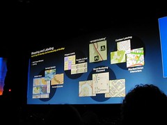
WYSIWYG Editing
ArcGIS 9.3 brings true What-You-See-Is-What-You-Get (WYSIWYG) editing of features and for cartographic representations. Currently, when a user drags an entity, it is shown in wireframe mode, but 9.3 dynamically shows what the actual feature will look like while being dragged.
Overlaps
9.3 has functionality that highlights overlaps, as well as a great new "disperse markers" feature, which allows overlapping markers to be automatically rearranged in a number of styles.
Cartographic Representations
For tips and tricks for enhanced cartographic standards and representations, and toward optimizing features and functionality in ArcGIS Desktop 9.3, ESRI has set up a "Mapping Center" website, located at http://mappingcenter.esri.com/.
Job Tracking Extension (JTX)
The new Job Tracking Extension offers interesting new functionalities for ArcGIS Desktop and Server 9.3. Essentially, it tracks and manages workflows.
(more to follow... trying to catch up with family first)
I had a chance to get my photos from the ESRI Conference trip off of my camera, and have posted a sampling of them to Flickr...
See the slideshow...
Unfortunately it's an old camera, I didn't have it with me for some of the events and sessions, and several of my photos did not come out, but I am posting what I can.
Plenary: Analysis!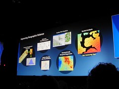
Map Gallery: Some of my stuff:
Cadastral Fabric: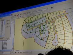
Marston Smith doing his electric cello thing...
Some good friends at the EPA booth: Left to right: Ayhan Ergul (Innovate), Wendy Blake-Coleman (EPA), Claudia Benesch (CSC), Jessica Zichichi (Innovate), and Riva San Juan (Indus)... Ayhan and Jessica won first place for the Embedded GIS category in the User Application Fair for the Metadata Editor, and Jessica also won the Women's Overall in the ESRI 5k run.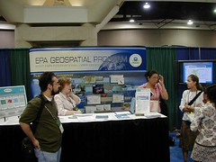
UC...
And more... check the slideshow out...
ESRI International User Conference 2007

Plenary Session, 6/18/2007 - Continued
Here continues my posting of notes from the UC... I left off with enhancements through the 9.2 SP 3, SP4 and 9.3 releases...
Imagery
ArcGIS Server will bring improved support for imagery, to allow more sophisticated processing and hyperspectral imagery. Tools from ERDAS and Leica systems will be able to work with imagery hosted on ArcGIS Server.
Raw imagery will be able to be sent directly to a web service.
Web Mapping
Web mapping tools will improve, with Ajax Map Tips, and transparent tools (such as for navigation).
ArcGIS Mobile
ArcGIS Mobile is a new set of components as a lightweight alternative to ArcPad, which allows integration with GPS, connected and disconnected editing.
ArcGIS Explorer
ArcGIS Explorer and ArcGIS Online continue to evolve.
Open Standards and Interoperability
Toward expanded support for Open Standards and Interoperability, a REST API for ArcGIS Server is being developed. Additionally, stronger OGC support is being pursued, along with improved ability to support mashups in Google and Microsoft Virtual Earth.
CAD Interoperability
ESRI Continues to develop and enhance ArcGIS for AutoCAD, and is pursuing improvements to support the CAD->GIS Workflow. In polling, 50% of ESRI users indicated they also use CAD software.
I wonder if ESRI is pursuing complete, if simple, CAD capabilities, to obviate the need for CAD packages for more casual users.
Other Notes:
Continued support for mashups is being pursued. Additionally, Replication within ArcSDE is being developed and expanded, to support work within an organization, where multiple departments must be coordinated.
ArcGIS Explorer and ArcGIS Online
Bernie Szukalski gave an overview of ArcGIS Online. ArcGIS Online makes a number of ready-to-use resources available to ArcGIS Explorer. These come in the form of prepublished map services and documents, which can be saved as .lyr files, and then consumed within ArcGIS Explorer. These include resources such as 1m US imagery, 2.5m SPOT imagery, and a number of other other data assets.
The ArcGIS Online site provides links to a number of online resources. Additionally, user data assets can be brought in. In an ArcGIS Explorer demo, USGS topos were brought in and draped over topography. Additionally, the Swipe tool allows users to swipe-drag layer visibility status to examine changes.
Another demo showed an ArcGIS Explorer task to perform ALOHA modelling of a toxic plume in ArcGIS Explorer. Here, a user could create a custom task to allow the user to specify a point and supply parameters, and then fetch and overlay the resultant plume.
Another ArcGIS Online feature discussed was online data delivery, using DataDoors technology, or via FTP or DVD.
Another new technology being promoted is the availability of ArcGIS Data Appliances. Here, ArcGIS data could be deployed in the field to remote locations, or deployed to secure environments residing behind an enterprise firewall. It was noted that currently ESRI is the leading provider of demographic data.
Other new technologies:
ArcLogistics
ArcLogistics was demonstrated by Carl Terry, which allows users to perform more sophisticated, rules-based routing and logistics than conventional routing tools such as ArcIMS Route Server and others offer. For example, ridership rules, appointment times, vehicle capacities and other parameters can be entered to build optimized routes. Terry stated 15-30% savings could be almost instantly realized for enterprises through the use of this type of logistics optimization.
Tech Support, Training and Education
Nick Frunzi gave an overview of efforts ongoing in customer support, training and other areas - he cited demand as resulting in a gap in support that was seen with the release of 9.2. Toward mitigating and improving customer support, his team is adding 30% more staff, and embedding support staff with developer teams to provide more robust domain expertise. As other new embedded support capability, diagnostic reporting and crash analysis is to be released in 9.3 products.
One piece of particularly exciting self-service support news is that in the next month, the internal ESRI knowledge base would be made available, in an online support center.
So overall, how is ESRI Doing?
15% growth this year...
(To be continued...)
Got home from the ESRI UC safe and sound... Barely slept, squeezed in on a packed redeye from San Diego to JFK. VerySpatial's Frank was also aboard my flight, we compared notes on the lack of sleep and cramped leg quarters... Like me, he is still working on digesting his notes and materials, but it sounds like the VerySpatial crew will have some great audio and other stuff to mix down, compile and otherwise post over the next week. Looking forward to it. I'm still on about page 5 of 40 of my notes...
I had a 2 hour nap earlier this afternoon, and have been spending the day catching up with my wonderful family, and I know I will sleep like a rock tonight.
Our good friends at Innovate won a few awards - Their Metadata Editor won an award, developed by Ayhan Ergul and Jessica Zichichi, and Jessica, who's a big runner, won herself a humongous trophy in the 5k race... More awards to be announced tonight.
Way to go!
For the second time in a row, I got ALL of the "Where In The World" imagery correct... though I imagine there are a number of other folks who also got them right... There are often a number of giveaways to help identify them, such as the glacial sediment at Nahanni NP, the distinctive shapes of Belize City, Arecibo Observatory and Angkor Wat, and so on...
It's always tricky to be in the right place at the right time for the drawings... always too much stuff going on.
This is one of hopefully many installments of notes:
ESRI International User Conference 2007
Plenary Session, 6/18/2007
The theme of the conference was The Geographic Approach, with emphasis on GIS as the Medium. For a battle-scarred veteran like myself, this is Mastery of the Obvious, and preaching to the choir, but again always good for reinforcing place-based approaches and toward refining the elevator speech for the less-initiated. My own mindset is of actually making GIS transparent, to the point of making it intuitive and invisible, to allow users to focus on the underlying field - such as environmental science and environmental protection - be it tracking where the a contaminant originated, where it's going and who it's impacting, or transportation networks, and the like.
ArcGIS 9.3
With regard to the roadmap for ArcGIS, there are anticipated to be several service packs prior to 9.3: ArcGIS 9.2 SP3 and 9.2 SP4 to serve as incremental releases. With 9.3, a number of other issues will be addressed, which may then also be released as hotfixes for 9.2.
What's new in 9.3? A sampling of features:
Survey Analyst
Clint Brown introduced of some of the enhancements to Survey Analyst - Survey Analyst is better supported through workflow functionalities, and greater emphasis was placed on maintaining the integrity of survey measurements within the context of the "parcel fabric".
Christine Leslie ran through a demo of integrating a CAD subdivision plan into an existing cadastral framework. The CAD plan in question was based on a local coordinate system, developed using COGO, and was copied and pasted into the cadastral layer. This brought the corners, along with any other relevant points, such as curve radius points, PCs and PTs in as point features, and brought in linework tied to these point features. Using the autojoin function, reference points in the CAD plan were matched up to the corresponding points in the cadastral base, and the autojoin function topologically integrated the CAD plan into the cadastral base. Next, a least squares adjustment was performed, with a report of residuals available. This of course still leaves me with some unease, however it's still suggested that all of the underlying data will remain with full integrity. Further, the same adjustment can then be applied to other layers, such as utilities or other features tied to the parcel.
"Easy to bring in from CAD"
With this Cadastral Fabric notion, the data model evidently still holds all of the original data, and incremental improvements are made. As long as the "Cadastral Fabric" is not purely rubber...
Evidently the underlying functionality is based on technology from GeoCadastre software, by Geodata Information Systems of Australia a
This piece will come to the market through ArcGIS 9.2 SP3's Survey Analyst.
Other ArcGIS 9.3 Functionality...
With ArcGIS Server 9.3, added improvesments come in terms of:
Support is to be added for:
As a general observation, they seem to be pushing ST_Geometry for PostgreSQL environments, as opposed to SDEBINARY.
SDE 9.2 brings GeoDatabase replication. This continues to evolve and mature in 9.3. The Replication Service can work via robust transaction messaging, update-o-grams. My curiosity is in how well this is supported in heterogenous environments - more on this later.
(to be continued...)
Just got in from another enjoyable day at the ESRI Conference today, last night's adventure was the GeoBlogger meetup at Mr. Tiki - got to met Daniel from FantomPlanet, Zen Master Dave Bouwman, Jesse, Sue and the rest of the Very Spatial team, and several others, close to 20 or so people turned out at Mr. Tiki. Google Earth graciously footed the bill, and filled us in on a lot of great stuff going on at Google. I did sample some of the "one of everything", but stayed away from the Large Drinks With Fruit And Umbrellas In Them.
I got to get out to several good sessions today. So often, however, I go from one item to the next, and find many gaps and overlaps in the projects that are being presented - many people all independently doing ver similar things in parallel, with little or no coordination between them. But fortunately folks like me spur conversation and put people together.
Still more reams of notes, and as it goes with these things, I start to suffer from mental overload. So what I am posting are not any actual notes, they are just a quick snapshot of the afternoon and evening... But time permitting, I will do a more thorough download as I get more time.
I did get to briefly sit in on the .NET SIG, hosted by Art Haddad, to see some very cool things being demoed as custom tasks for ArcExplorer, such as an animated wind velocity demo, which allowed custom symbology which actually changed to successively more sophisticated vectors as the user zooms in and out of the model. Unfortunately I didn't have my camera at the ready, but I did see that Dave Bouwman snapped a shot of it.
Another great item was the AGS mobile SDK - looks like a rich set of components for .NET, to support connected and disconnected, cached map viewing and editing, as well as GPS connectivity.
I then departed early to meet up with a group of friends to catch the Padres-Orioles game at Petco Park... Unfortunately the Padres were routed 7-1, some brilliant pitching by the Orioles' Guthrie. On the Padres' side, Branyan managed to hit a homer, the sole score of the night. The Orioles' Tejada took an errant pitch to his wrist, looked painful. Another highlight of the evening was definitely the purposeful loping of a random guy across the field, sliding into base as it were, and culminating with a fullblown tackle and cuffing.
GBM provides income and sustenance to millions of people in Kenya through the planting of trees. It also conducts educational campaigns to raise awareness about women's rights, civic empowerment, and the environment throughout Kenya and Africa.
How You Can Help
There are many ways to contribute to our work. Make a donation directly to GBM. Find out more about our Green Belt Safaris. Offset your carbon footprint by planting trees (forthcoming). Or buy Wangari Maathai’s books.

Christopher Schmidt has an IRC chat set up for realtime info on the ESRI UC....
Get the blow-by-blow: http://crschmidt.net/irc/irc.cgi
The Nature Conservancy is the recipient of this years Presidents award...
Jack is speaking to the theme of the Geographic Approach, but thus far, another underlying theme is Enterprise GIS and Web 2.0... Will the main focus be pushing ArcGIS Server? Rhetorical question... no answer needed...
Just getting settled into my room... My plane was supposed to leave JFK at 5:45PM, we ended up not getting into the air until after 7:45, so it's pretty late at this time... I'll be the sleepy guy if you see me at the ESRI UC tomorrow...
This was written earlier tonight, as I was awaiting my next flight, from JFK to San Diego, no WiFi available...
I shouldn't be so hard on Binghamton, it's actually a nice little airport in a beautiful location, out in the rolling hills of New York's Southern Tier. And no, no cropduster - it was an Embraer 145.
I don't think I've flown out of JFK in quite a few years... Typically it's a much easier drive for me to go straight to Newark, easy-in and easy-out, just a hair over an hour drive, and if I need to fly out of a larger airport, usually Newark does the trick. JFK adds a lot to that trip. But, for whatever odd reason, these airfare pricing schemes are always a mystery. No deals to be had out of Newark this time... and as usual, my local airport's pricing was ridiculous. It also occasionally amazes me how transcontinental airfare from B to C might be $700, but from A to B, and then that identical transcontinental flight from B to C might only total $500.
The guy that devised their pricing algorithms must either be a complete genius, as the methodology is so profoundly inscrutable, or he must be a demented idiot. Given that the airlines are constantly struggling to make ends meet, I unfortunately have to cast my vote for the latter.
Sitting in the Binghamton airport, on the drive up, the thought crossed my mind that I might be flying on a cropduster for the first hop to JFK.
It still mystifys me how the airlines work their pricing algorithms...
But at least I end up saving around 300 bucks... and TSA wasn't screening any sheep and other livestock through...
I have to admit, I think I'm getting a bit too much of my royal GIS geek on...

Yes, that actually is ArcPad, loaded up with base maps for San Diego, and I created a few extra layers, with trolley routes, BatchGeocoded places of interest, and plenty of other goodies in advance of the ESRI UC, and I'll be tooling around with bluetooth GPS to boot... As usual, I'll be loaded, downloaded, wired, WiFi'd, bluetoothed, GPS'ed, web 2.0'd, AJAXed, geo-enabled, deepfried and sanctified...


