I certainly have much to be thankful for this year, and celebrated a nice Thanksgiving with family. The traditional imagery of Thanksgiving, of puritan English pilgrims celebrating a feast of thanks with the indiginous Americans leaves me with many mixed thoughts given the later fate of indiginous people, a discussion perhaps best left for another day.
My own family first came to New England in 1623, not long after this first Thanksgiving, with Governors Thomas Dudley and Simon Bradstreet (Massachussetts Bay Colony), also Puritans, being among my ancestors.
I did find a few interesting maps relating to the early Plymouth Colony at this site: http://etext.virginia.edu/users/deetz/Plymouth/plymaps.html
I did find a few interesting maps relating to the early Plymouth Colony at this site: http://etext.virginia.edu/users/deetz/Plymouth/plymaps.html

This would have been the colonists' view of New England, as they set sail - from the website description,
Captain John Smith's map of New England, dated 1614.
The map was probably drawn by Simon van der Passe, the son of a Dutch engraver, based on one drawn by John Smith. It is very similar to an earlier version which omitted the "New" which prefaces "Plimouth," and does not include Salem. The English colonists who settled in Plymouth in 1620 almost certainly had access to this map. In his Advertisements for the Unexperienced Planters of New England, or Any Where (London, 1631), Smith commented wryly: "Now since them called Brownists went, some few before them also having my bookes and maps, presumed they knew as much as they desired . . . " (The Complete Works of Captain John Smith (1580-1631), ed. by Philip L. Barbour (Univ. Of North Carolina Press, 1986), vol. 3, p. 285.
Reprinted in Deetz and Deetz, The Times of Their Lives, p. 70.
Also featured in this map archive is the following:

The only known map of the town layout, as drawn by William Bradford in 1620. From the site,
William Bradford's sketch of the town of Plymouth.
The Bradford sketch, entitled "The meersteads & garden plots of which came first layed out 1620" is the only known map of the original town layout. The sketch is bound into the front of a manuscript volume entitled "Plimouths Great Book of Deeds of Lands Enrolled from Ano 1627 to Ano 1651." The first part of the volume is in the handwriting of Governor William Bradford, as is the map. The volume now comprises Vol. 12 , Deeds, &c. Vol. 1 1620-1651 of The Records of the Colony of New Plymouth in New England, edited by Nathaniel B. Shurtleff and David Pulsifer (William White, 1855-61; AMS Press, 1968).
John A. Goodwin, in his The Pilgrim Republic (Boston: Houghton Mifflin, 1920; Kraus reprint 1970), has extended the plan to include his interpretation of the position of occupants on the north side of the street, and of the street in relation to the harbor and the fort.
The original Bradford sketch is reprinted in Deetz and Deetz, The Times of Their Lives, p. 66.
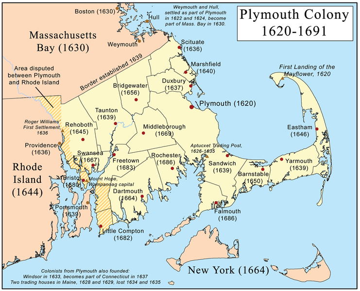
Finally, from Wikipedia's entry on the Plymouth Colony, a map showing the geographic extent of the Plymouth Colony:


0 Response for the " Thanksgiving "
Post a Comment