I finally got around to upgrading my mobile platform. I had been toting around my Motorola cellphone, iPaq, Holux GPSlim 240 bluetooth GPS, and all of the associated iGo tips and other associated cables...
I looked at a number of units, Blackberries, Treos, Nokia N95 (very nice), along with the Samsung BlackJack (BlackJack II coming soon), Motorola MotoQ and others - but ultimately narrowed things down to Windows Mobile, as I have a lot of software for that platform (ArcPad, navigation, et cetera) - and Windows Mobile can run your selection of Java VM as well - best of both worlds.
Yesterday, I ended up getting the HTC TyTn II (also known as AT&T Tilt and by a few other names) - and I'm pretty happy with it thus far. It's the only Windows Mobile unit that I came across to feature BlueTooth, WiFi, 3G Data, and integrated GPS. It also has a 3 megapixel camera to boot.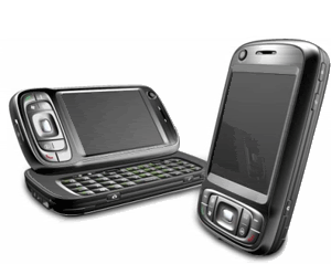
I'm still looking to pick up a nice big MicroSD card, so I haven't yet loaded it up with a lot of stuff, but I have been playing with Google Maps Mobile, Microsoft Live Search Mobile (Virtual Earth), and Mobile GMaps on the Esmertec JBed JVM that ships already installed on the HTC unit. Notably, when I went to Esmertec's site, I was greeted with an Android info page, so I may be looking at gPhone apps as well.
Pretty nice, so far! I am looking forward to developing some things that take advantage of this new platform...
Mobile Geospatial
Thanksgiving
I did find a few interesting maps relating to the early Plymouth Colony at this site: http://etext.virginia.edu/users/deetz/Plymouth/plymaps.html

This would have been the colonists' view of New England, as they set sail - from the website description,
Captain John Smith's map of New England, dated 1614.
The map was probably drawn by Simon van der Passe, the son of a Dutch engraver, based on one drawn by John Smith. It is very similar to an earlier version which omitted the "New" which prefaces "Plimouth," and does not include Salem. The English colonists who settled in Plymouth in 1620 almost certainly had access to this map. In his Advertisements for the Unexperienced Planters of New England, or Any Where (London, 1631), Smith commented wryly: "Now since them called Brownists went, some few before them also having my bookes and maps, presumed they knew as much as they desired . . . " (The Complete Works of Captain John Smith (1580-1631), ed. by Philip L. Barbour (Univ. Of North Carolina Press, 1986), vol. 3, p. 285.
Reprinted in Deetz and Deetz, The Times of Their Lives, p. 70.
Also featured in this map archive is the following:

The only known map of the town layout, as drawn by William Bradford in 1620. From the site,
William Bradford's sketch of the town of Plymouth.
The Bradford sketch, entitled "The meersteads & garden plots of which came first layed out 1620" is the only known map of the original town layout. The sketch is bound into the front of a manuscript volume entitled "Plimouths Great Book of Deeds of Lands Enrolled from Ano 1627 to Ano 1651." The first part of the volume is in the handwriting of Governor William Bradford, as is the map. The volume now comprises Vol. 12 , Deeds, &c. Vol. 1 1620-1651 of The Records of the Colony of New Plymouth in New England, edited by Nathaniel B. Shurtleff and David Pulsifer (William White, 1855-61; AMS Press, 1968).
John A. Goodwin, in his The Pilgrim Republic (Boston: Houghton Mifflin, 1920; Kraus reprint 1970), has extended the plan to include his interpretation of the position of occupants on the north side of the street, and of the street in relation to the harbor and the fort.
The original Bradford sketch is reprinted in Deetz and Deetz, The Times of Their Lives, p. 66.
Finally, from Wikipedia's entry on the Plymouth Colony, a map showing the geographic extent of the Plymouth Colony:
Puget Sound Information Challenge
Posting live from EPA's Environmental Symposium in St. Louis - One of the things that's being discussed there is a challenge put forth by Bill Ruckelshaus, former EPA Administrator, who is now heading up the Puget Sound Initiative, to clean up this natural resource that forms a big part of Northwest Washington State.
As part of this, they established a wiki, and are having mashup camps to rapidly get as much content relating to Puget Sound and its' environment as possible:
In a few short hours, I was able to develop a Virtual Earth mashup, which performs MetaCarta searches against EPA and other federal and state documents, pulls in EPA Toxic Release Inventory for Washington State as a KML layer, WMS layers for USGS Wetlands and Land Cover (NLCD), as well as NHD layers showing streams and impaired waters.
There is also a great OpenLayers-based mashup builder and other tools - anyone interested in improving the environment in the Puget Sound area will be encouraged to participate as things move forward.
I also built a standalone version here: http://www.synergist-tech.com/Demo1/PugetSound.html


