As we come up on this eve before Election day, I will pass along this humorous, yet true item from my friend Gene Kooper, Executive Director of the Professional Land Surveyors of Colorado.The below topo map fragment is from the Georgetown, CO 7 1/2 minute quad topo. In case you think it's bogus, the NGS Data Sheet is included. Regardless of your political views, please exercise your right to vote.
Whether you believe the brass cap is just a "pimple on a Grand Ol' Mountain" or a "Proud Shining Beacon of Democracy" atop a minor hill in the shadow of the Continental Divide, it doesn't matter!
In the end, we are all Americans.
GET OUT AND VOTE TOMORROW!!
1 National Geodetic Survey, Retrieval Date = NOVEMBER 3, 2008
KK2035 ***********************************************************************
KK2035 DESIGNATION - DEMOCRAT
KK2035 PID - KK2035
KK2035 STATE/COUNTY- CO/CLEAR CREEK
KK2035 USGS QUAD - GEORGETOWN (1974)
KK2035
KK2035 *CURRENT SURVEY CONTROL
KK2035 ___________________________________________________________________
KK2035* NAD 83(1992)- 39 42 51.68709(N) 105 44 07.70429(W) ADJUSTED
KK2035* NAVD 88 - 3781. (meters) 12405. (feet) VERTCON
KK2035 ___________________________________________________________________
KK2035 LAPLACE CORR- -11.78 (seconds) DEFLEC99
KK2035 GEOID HEIGHT- -12.45 (meters) GEOID03
KK2035
KK2035 HORZ ORDER - THIRD
KK2035
KK2035.The horizontal coordinates were established by classical geodetic methods
KK2035.and adjusted by the National Geodetic Survey in January 1993.
KK2035
KK2035.The NAVD 88 height was computed by applying the VERTCON shift value to
KK2035.the NGVD 29 height (displayed under SUPERSEDED SURVEY CONTROL.)
KK2035
KK2035.The Laplace correction was computed from DEFLEC99 derived deflections.
KK2035
KK2035.The geoid height was determined by GEOID03.
KK2035
KK2035; North East Units Scale Factor Converg.
KK2035;SPC CO C - 513,640.813 894,210.473 MT 0.99999314 -0 08 54.6
KK2035;SPC CO C - 1,685,169.90 2,933,755.53 sFT 0.99999314 -0 08 54.6
KK2035;UTM 13 - 4,396,313.019 436,959.085 MT 0.99964893 -0 28 11.8
KK2035
KK2035! - Elev Factor x Scale Factor = Combined Factor
KK2035!SPC CO C - 0.99940919 x 0.99999314 = 0.99940233
KK2035!UTM 13 - 0.99940919 x 0.99964893 = 0.99905833
KK2035
KK2035: Primary Azimuth Mark Grid Az
KK2035:SPC CO C - GRINDAL 152 24 17.9
KK2035:UTM 13 - GRINDAL 152 43 35.1
KK2035
KK2035|---------------------------------------------------------------------|
KK2035| PID Reference Object Distance Geod. Az |
KK2035| dddmmss.s |
KK2035| KK2034 GRINDAL APPROX. 8.1 KM 1521523.3 |
KK2035|---------------------------------------------------------------------|
KK2035
KK2035 SUPERSEDED SURVEY CONTROL
KK2035
KK2035 NAD 83(1986)- 39 42 51.68858(N) 105 44 07.70290(W) AD( ) 3
KK2035 NAD 27 - 39 42 51.73222(N) 105 44 05.69354(W) AD( ) 3
KK2035 NGVD 29 (07/19/86) 3779. (m) 12398. (f) VERT ANG
KK2035
KK2035.Superseded values are not recommended for survey control.
KK2035.NGS no longer adjusts projects to the NAD 27 or NGVD 29 datums.
KK2035.See file dsdata.txt to determine how the superseded data were derived.
KK2035
KK2035_U.S. NATIONAL GRID SPATIAL ADDRESS: 13SDD3695996313(NAD 83)
KK2035
KK2035 HISTORY - Date Condition Report By
KK2035 HISTORY - 1903 MONUMENTED USGS
KK2035 HISTORY - 1956 GOOD USGS
KK2035
KK2035 STATION DESCRIPTION
KK2035
KK2035'DESCRIBED BY US GEOLOGICAL SURVEY 1956 (EEM)
KK2035'RECOVERED AS DESCRIBED.
KK2035'
KK2035'STATION LOCATED 2 MI. W. OF GEORGETOWN, ON REPUBLICAN MOUNTAIN.
KK2035'
KK2035'POINT IS BEST REACHED BY FOLLOWING TRAIL UP FIRST PROMINENT GULCH N.
KK2035'OF GEORGETOWN, JUST AT THE CITY LIMITS. FOLLOW THIS TO SUMMIT OF
KK2035'MOUNTAIN, THENCE S. ALONG RIDGE TO HIGHEST POINT.
KK2035'
KK2035'STATION MARK--STANDARD BRONZE TRIANGULATION TABLET CEMENTED IN SOLID
KK2035'ROCK NEARLY AT HIGHEST POINT OF MOUNTAIN, STAMPED ---DEMOCRAT
KK2035'1903-1956---.
KK2035'
KK2035'REFERENCE MARK NO. 1--STANDARD USBR (1936) BENCH MARK TABLET CEMENTED
KK2035'IN SOLID ROCK, 5.07 FT. DISTANT FROM STATION MARK,
KK2035'S 36 DEG 40 MIN W
'Twas the Eve before Election Day...
USGS Pilot Project Makes High-Quality Landsat Data Available Through Web
 As of June 4, 2007, the USGS will be releasing selected Landsat 7 image data of the United States through the Web (glovis.usgs.gov or earthexplorer.usgs.gov). These data are of high quality with limited cloud cover (referred to as the Landsat ETM+ SLC-off L1T Standard Product).
This Web-enabled distribution of new and recently acquired data is a pilot project for the Landsat Data Continuity Mission (LDCM), currently projected for launch in 2011.
The project will allow the Landsat data user community to help refine the distribution system planned for the upcoming LDCM. Each scene will be registered to the terrain, or “ortho-rectified,” prior to being placed on the Web. Copies of these data will also be available on CD or DVD at the cost of reproduction. Landsat data have proven useful for a wide range of applications. From disaster monitoring after Hurricane Katrina and the Indonesian tsunami to global crop condition analysis, Landsat data are being used by scientists around the world.
The Web-based distribution system will allow the user community easier access to Landsat 7 data. The pilot project will be carefully examined. Customer response will be evaluated and their insight will influence the future distribution system.
Rachel Kurtz, PhD
Data Acquisition Manager, Acting
Landsat Project
USGS EROS
Land Remote Sensing Program
Sioux Falls, SD 57198
Geospatial Liaison Positions at USGS

Today the U.S. Geological Survey published vacancy announcements for the Geospatial Liaisons for Washington, Oregon, and several other states.
Information on the announcements is below. These jobs are open to all qualified applicants and are not restricted to current USGS or Federal government employees. Questions on the application process can be answered by Nina Fralick (nfralick@usgs.gov).Here's the information and links to the announcements:
Applicants qualified for either the Physical Scientist or
Cartographer series are being sought for the following locations. These
positions are open simultaneously with equivalent ones in Maine, Georgia, West
Virginia, and Nebraska, and all announcements are accessible at the OARS website
(http://www.usgs.gov/ohr/oars/) and
on USAJobs ( http://www.usajobs.gov/).
- 1 vacancy in Anchorage, AK
- 1 vacancy in San Diego, CA or Pasadena, CA
- 1 vacancy in Seattle, WA or Tacoma, WA
- 1 vacancy in Portland, OR
- Physical Scientist - Merit Promotion -
Announcement WR-2007-0224
https://jobs1.quickhire.com/scripts/usgs.exe/runjobinfo?aOrg=1&aJob=11045&Username=~BROWSE~&ORGIMG=usgs.gif- Cartographer - Merit Promotion - Announcement
WR-2007-0227
https://jobs1.quickhire.com/scripts/usgs.exe/runjobinfo?aOrg=1&aJob=11051&Username=~BROWSE~&ORGIMG=usgs.gif- Physical Scientist - DEU - Open to Public - Announcement
WR-2007-0223
https://jobs1.quickhire.com/scripts/usgs.exe/runjobinfo?aOrg=1&aJob=11044&Username=~BROWSE~&ORGIMG=usgs.gif- Cartographer - DEU - Open to Public - Announcement
WR-2007-0226
https://jobs1.quickhire.com/scripts/usgs.exe/runjobinfo?aOrg=1&aJob=11050&Username=~BROWSE~&ORGIMG=usgs.gif
Pay Plan, Series, and Grade: GS-1370-12/13
Open Date: 01/30/2007 Close Date: 02/20/2007
Contact: Nina Fralick
(nfralick@usgs.gov)
ESRI FedUC Wednesday...
Just got back from the reception at the Organization of American States - many great conversations, and overall a very productive day for me.
 I sat in on a few of the Homeland Security and Emergency Response sessions - we are having an ever expanding role in that arena. Prominent was IRRIS, from our business partners and fellow Pennsylvania firm, GeoDecisions. We are currently looking at some possibilities for bringing data from mobile sensor platforms directly into IRRIS, as well as dynamic search and discovery possibilities for sensor data - will be interesting to see how it all unfolds.
Other Homeland Security / Emergency Response sessions touched on EMMA, as a good model for statewide emergency management with wide stakeholder support.

There was a good session on NIMS, as it moves forward. The pieces are rapidly falling into place for broader integration and use of incident data, the vision of local-state-federal finally becoming more of a reality. Within NIMS, they mentioned the NOAA plume modeling facility, which is continually run for known sites, utilizing current weather conditions. My wonder is in how well this is or can be tied into available facility data for all of the applicable EPA FRS sites. The NIMS document is currently being revisited for updating, presenting many new opportunities to harmonize incident management efforts across agencies.
It makes a great deal of sense to get ever more stakeholders put together, not just for simple data sharing, but also for lessons learned, sharing of SOPs, models, types of analyses performed, and so on. One report cited as an excellent resource is the 2007 National Academy of Sciences Report, Successful Response Starts with a Map: Improving Geospatial Support for Disaster Management, which cites a number of areas for improvement - for example that data standards do not yet meet emergency response needs, and that training and exercises for responders need geospatial intelligence built into them.
While we didn't have a booth at this event, I saw at least one fellow SDVOSB exhibitor, Penobscot Bay Media - they are doing work in LIDAR scanning mounted on a robotic platform. We talked VETS GWAC a bit... My friends at the EPA booth saw some very brisk business, although they didn't manage to draw Jack Dangermond in. We did catch up with Jack later (will post the picture another time, as it was not my digital camera...)
I got a few minutes to chat with Adena Schutzberg, of Directions Magazine, All Points Blog, and many other good things - she was my Teaching Assistant way back when, at Penn State for Spatial Analysis with Dr. Peter Gould. A few encouraging words from her on my blog and the many diverse things I manage to get my fingers into...
The final sessions I got to sit in on - I had a few meetings here and there, which punctuated the day, and unfortunately ended up missing the GeoLoB discussion, but caught the tail end of the Geospatial One Stop presentation by Rob Dollison of USGS. He discussed a number of things coming down the pike in the next few months, as build 2.1 gets pushed to production in the next month or so, 2.2 in March-June timeframe, followed by 2.3 - many interesting enhancements, such as search relevance, search booleans, viewing results as a bounding box, a fast base map, 3D viewing, and so on. Exciting stuff. On our end, we are looking for ways to tie our GPT instance at EPA, the GeoData Gateway, into GOS, through the EPA firewall, and using integrated security. We are lucky there to have Marten Hogeweg and the same ESRI team working with us that developed GOS.
One thing that had me wondering on the implementation was "authoritative data sources". Here, the intent would be to present "authoritative data sources" in the search results near the top. Will this be another field in the metadata record? Is it determined by virtue of its' publisher?
At any rate, it was an enjoyable day, saw many friends, had a lot of exciting and productive discussion, and I am looking forward to more of the same tomorrow. But now, I'm ready for bed...
Best Practices and MetaCarta
I have several interesting things cooking in the next few weeks – One we just had a kickoff for - Agency Best Practices, which follows much of what I have already been doing in Geospatial Enterprise Architecture, but which is all the more serendipitous in light of the Geospatial Line of Business effort by OMB. I have already been working on a concept of operations for transitioning to and implementation of reusable, distributed service components for geospatial business (SOA and other enterprise-level solutions). My previous effort will be expanded and merged with efforts by other Domain Experts in other arenas, such as Portal/SSO, Service-Oriented Architecture, ETL, and other technologies. I’m putting a draft together for May 15th.
 The other is to perform another MetaCarta integration, this one to geo-enable a repository containing 50 million documents, for MetaCarta-powered geocoding and mapping. I will likely follow a similar model as the previous integration project, using ArcIMS and existing enterprise mapping as the base with a query interface, perform the SOAP call to the appliance, parse the response and plot them on an acetate layer. This one will be a new J2EE implementation from scratch, as opposed to the previous one, which was an integration into a legacy ASP/IIS-based application.
Technorati tags:
applications, arcims, asp, design, developer, environment, environmental protection, epa, esri, geo, Geography, Geospatial, gis, internet, javascript, map, mapping, maps, metacarta, microsoft, programming, symbolization, symbology, tools, UI, user interfaces, usgs, vb, visual basic, visualization, web services, webmapping, website
Geospatial One Stop Wins Award
 GeoCommunity Spatial News reports that the Geospatial One Stop won an award via Excellence.Gov. Cited was support for Katrina and Rita. Some of you will lavish your praise and congratulations on GOS and ESRI, while I know others of you may have mileage that varies...
I do congratulate ESRI and the GOS team - but while I think GOS is going in the right direction, and has become a vital piece of infrastructure, I'm not sure it's quite there yet.
Technorati tags:
community, e-government, ea, emergency response, esri, fea, federal, geo, Geospatial, gis, gos, imagery, interoperability, Katrina, mapping, metadata, news, opinion, portal, spatial, usgs, weather
Architecture, MetaCarta and other stuff....
Haven't posted in a few days, things have been very hectic. We serendipitously have synergy of many things coming together at once - an excellent opportunity to rearchitect a number of legacy GIS databases and applications for 2006, at the same time that new Federal Enterprise Architecture guidance and other technology items are arriving on the scene, such as enhanced support for OGC standards in the pipeline from Dr. Sharma and the Oracle Spatial team and from ESRI. I've been spending a lot of time over the last two weeks trying to go from high-level enterprise standpoint to solution architecture across over a dozen systems, identifying the gaps, overlaps, and opportunities for standardization, FEA realignment and reusability. This also ties in well with work I'm doing for the USEPA Geospatial Metadata/Data/Services Architecture project I've been involved in since the fall. Apart from that, plenty of exposure on a few other things- the 2006 MetaCarta Public Sector User's Group meeting at Tyson's Corner on the 16th is going to highlight one of our recent successes in integrating MetaCarta technology into the USEPA "Window To My Environment" application. I'm hoping to attend for at least part of it.For anyone interested in attending the 2006 MetaCarta Public Sector UG, I think they may still have some (very limited) space remaining... Details are available on the MetaCarta website, or you can contact my good friend John-Henry Gross, 703-629-0972. I note that one of the highlights is that John-Henry will be discussing the new GTS Analyst feature, as well as some enhancements in the GIS Connector and other additions and improvements.
This WME/MetaCarta application is also going to be featured at the upcoming USEPA Contractor Forum as well...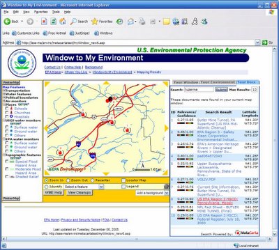
Technorati tags:
applications, arcims, asp, design, developer, environment, environmental protection, epa, esri, geo, Geography, Geospatial, gis, internet, javascript, map, mapping, maps, metacarta, microsoft, programming, symbolization, symbology, tools, UI, user interfaces, usgs, vb, visual basic, visualization, web services, webmapping, website
ESRI Federal Users Conference Tomorrow...
 I'm registered for the ESRI Federal Users Conference tomorrow through Thursday... I'm looking forward to seeing the speakers, vendors, exhibits and old cameraderies, particularly our friends, partners and folks that we have done work with over the years, like Metacarta, SRA International Inc., Topcon Positioning Systems, Inc., BAE Systems ADR, i-cubed, Michael Baker, GeoDecisions, Trimble, Thales Navigation, Safe, and others... however things are going to be tough.
I have quite a few other meetings around the DC area booked throughout the week as well. I'm hoping to do a couple of hit-and-run attendances throughout the week but as far as any substantial block of time, it looks rough.
For anyone else who is thinking about attending but who doesn't have the info, I'd highly recommend it...
http://www.esri.com/events/feduc/index.html
Hope to see you there!
Technorati tags:
aerial photography, analysis, applications, arcgis, arcgis desktop, arcgis explorer, arcgisexplorer, arcgisserver, arcims, arcsde, arcweb, business, cartography, e-government, esri, esri developer network, events, federal, geo, Geospatial, gis, gps, mapping, metacarta, navigation, professional, remote sensing, spatial, usgs, webmapping
Landsat 5 is back operational

Directions Magazine happily reports that Landsat 5 is back online. In November, the spacecraft began experiencing problems with the drive mechanism for the solar array. Out of concern for its inability to recharge, imaging operations were halted. After working with the spacecraft, they have now apparently identified a fix in operational procedures that avoids the problem and are resuming operations. Landsat 5 was originally launched in 1984.
The Landsat website is available at the following location:
Technorati tags:
earth observation, environment, geo, Geography, Geospatial, imagery, landsat, mapping, NASA, news, remote sensing, satellite, science, space, usgs
InSAR and Seismic Modeling
A few weeks back I found a recent article about InSAR (Interferometric Synthetic Aperture Radar) for tracking subsurface movement quite fascinating, with a multitude of potential applications.
Today's Los Angeles Daily News is carrying an article discussing a $6M supercomputer system unveiled at Caltech a few months ago. This system can perform extensive seismic modeling tasks for post-quake rescue deployment, based on the model's analysis of most hard-hit communities and models of structural behavior in buildings.
Evidently the Caltech system tracks seismic waves, along with GPS data, and computes which areas have aftershocks likely, and which areas have buildings which are likely to sustain damage from a quake. The article also briefly touches on the use of GPS and InSAR to track subsurface stresses and to monitor what happens before, during and after an earthquake.
Per Lucy Jones, USGS, ultimately these modeling capabilities along with remote sensing methods for monitoring stresses and movement will need to be communicated with a broader community - structural engineers, architects and planners, building and zoning officials, as well as emergency responders, to be able to act as an integrated team for minimizing earthquake damage.
The Whittier Daily News also has an article today on the supercomputer, called CITerra, consisting of 25 racks of Dell PowerEdge blades, ranking the cluster as number 41 of the world's 500 most powerful supercomputers.
Technorati tags:
analysis, applications, architecture, community, crustal motion, design, earth observation, emergency response, engineering, environment, geo, geodesy, geodetic, gps, InSAR, news, planning, radar, remote sensing, rescue, sar, science, seismic, supercomputers, usgs
Feedback wanted
Looking for thoughts and input to improve the EPA's Window To My Environment application-
http://www.epa.gov/enviro/wme/
Enter your City/State or ZIP code, and the application will render a map window, with the ability to query environmental, demographic, and facilities data.
Aside from the Metacarta pilot we are working on (still in staging) our team will have a further opportunity to update and enhance this legacy EPA application with regard to usability, functionality, user interface, performance, et cetera. If anyone has any thoughts, suggestions, recommendations, please contact me: dsmith@synergist-tech.com
Technorati tags:
applications, arcims, asp, design, developer, environment, environmental protection, epa, esri, geo, Geography, Geospatial, gis, internet, javascript, map, mapping, maps, metacarta, microsoft, programming, symbolization, symbology, tools, UI, user interfaces, usgs, vb, visual basic, visualization, web services, webmapping, website
Landsat 8 planned for 2010
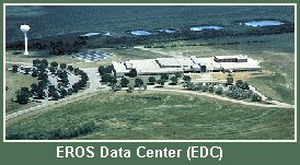
It's being reported in Sioux Falls that the USGS EROS Data Center is planning for the next Landsat offering, unveiled to be on the way just before Christmas by the White House's Office of Science and Technology Policy. EROS will evidently have considerable input on the design of the vehicle, budgeted at $338M. With the loss of Landsat 6 on launch in 1993 and glitches in Landsat 7 and 5, I'm sure this comes as a tremendous relief to the program.
Of note on the Office of Science and Technology Policy website is the "Strategic Plan for the U.S. Integrated Earth Observation System"...
Technorati tags:
earth observation, environment, federal, geo, Geography, Geospatial, gis, landsat, mapping, news, remote sensing, satellite, science, space, usgs
PAMAP Raster Design Concept Complete
 Chris Markel, Implementation Manager for the PAMAP Program (Pennsylvania's implementation of the National Map) announces that the final version of the Raster Conceptual Design for the PAMAP Program has been completed.
This document is available for download at the PAMAP Web site at Pennsylvania DCNR:
http://www.dcnr.state.pa.us/topogeo/pamap/index.aspx
The report is also accompanied by a poster showing the proposed geodatabase design for raster data elements.
As a personal note, I am pleased and honored to have been a contributor on some portions of PGDSS (including being author of the Geodetic Monumentation portion of the standard) and many work sessions and comment periods leading up to this PAMAP effort.
Kudos to Chris and the team and thanks for all the hard work.
Technorati tags:
atlas, cartography, collaboration, community, consortium, geo, geodesy, geodetic, Geography, Geospatial, gis, interoperability, map, mapping, maps, metadata, pennsylvania, raster, remote sensing
USGS Cartographic Service Contracts
 We have been invited to participate in a solicitation for a USGS Cartographic Service Contract. It's great, as a small business, to be recognized for your capabilities and to be included in an opportunity to compete with the "big boys"- typically the ENR 200 firms.
We do plan to respond- we (and I would imagine many other firms) can easily address most aspects of the work, however one component still is the ability to provide imagery- it's not every company that is capable of deploying the aerial or spaceborne platforms and sensors for aerial imagery or other remote sensing imagery... We do have a few tricks up our sleeves, with a network of regional firms that have these conventional capabilities, as well as some advanced technology from some of our friends who do military contracting.
http://erg.usgs.gov/isb/pubs/factsheets/fs06603.html


 Posts
Posts


