
Technorati tags:
conversion, coordinates, CORS, events, federal, geo, geodesy, geodetic, Geospatial, GIS, GPS, map, mapping, maps, news, NGS, NOAA, NSRS, spatial, surveying


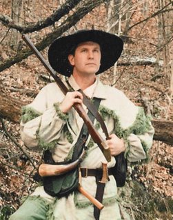
Patrick Lee
as Daniel Boone

I am looking forward to spending some time over the next few days at the Pennsylvania Surveyors' Conference. It's always a great time to catch up with old friends, as well as get some updates on various things going on in the world of surveying and mapping. This year I am going to focus on the GPS track, something I have not been doing my due dilligence on of late.
On another note, it's beginning to amaze me how many geospatial-related conferences are cropping up of late. I just got a notice of the Rocket City conference in Huntsville, and there have been several others in the last few months and more upcoming. I can certainly understand thematic conferences, regional ones, vendor-
oriented ones... but are we getting to the point where there are just too many?

A battle is imminent, with several professional societies challenging the Federal Government on whether the Brooks Act should apply to geospatial contracting efforts.
A trial is scheduled for February 2nd, Private Photogrammetric Surveyors (MAPPS), American Society of Civil Engineers (ASCE), National Society of Professional Engineers (NSPE) and Council on Federal Procurement of Architectural and Engineering Services (COFPAES) v. United States of America - to provide definition and clarity and to look toward Qualifications-Based Selection (QBS) in mapping procurements.
Directions Magazine provides their perspective on the issue, and drew my attention. MAPPS provides a page discussing the background and legal history.
The outcome should prove interesting - many issues have been simmering with regard to state and federal definitions of surveying and mapping, particularly as technologies have continued to evolve. I have my own unique perspective, as a geospatial practitioner, as a licensed professional, and as a member of a state licensing board - and these perspectives are in some ways in great harmony, largely in support of Qualifications-based Selection, however also in some ways in dissonance with QBS, as mere fact of licensure may not qualify one to perform the work. As a regulatory body, the State Registration Boards' duty is to ensure protection of the public - and in many ways, lack of adherence to the Brooks Act has skirted this. However, many state laws are similarly overbroad, and/or antiquated.
Just received this announcement from a colleague:
National Land Cover Database (NLCD 2001)
The U.S. Geological Survey, on behalf of the interagency Multi-Resolution Land Characteristics Consortium (MRLC), is pleased to announce the availability of NLCD 2001 products for the conterminous United States. These products are web enabled for download from the MRLC website at www.mrlc.gov. NLCD 2001 products include 21 classes of land cover, percent tree canopy and percent urban imperviousness at 30 m resolution derived from Landsat imagery. NLCD 2001 will support a wide variety of users, institutional sectors and local- to national-scale applications with this updated land-cover data. Alaska, Hawaii, and Puerto Rico will be completed by December of 2007, which will then represent the first compilation of nationwide land cover ever produced at 30-meter resolution.
 Great news for a wide variety of applications - I was just looking at a watershed application, myself, where this data will fit quite nicely.
I did a quick check, it's not yet visible in the MRLC map viewer, however the data is available via FTP - visit the Multi-Resolution Land Characteristics site: http://www.mrlc.gov/
Having a five-year-old in the house, I usually snag any little conference goodies, such as the LizardTech lizards, yo-yos, and other things of interest... And ESRI never fails to please with a few goodies of their own at the User Conferences.
One interesting one is the Mapping for Congress book, published by ESRI press, it was distributed in the conference bags at sign-in. In usual case-study style, they present a gallery of interesting maps that were developed in response to various Congressional inquiries and toward exhibits and policy development by the Library of Congress Congressional Cartography Program. Plenty of great studies toward support of public policy, social justice and other areas to be found in this book.
Another one that I grabbed at the conference was GIS for Homeland Security, which in a vest-pocket size, provides a good high-level overview of various initiatives, Homeland Security Presidential Directives, and other ongoing efforts toward preparedness and response. A great feature of this book is the extensive glossary, which provides over 30 pages of definitions and explanations of the various terms, definitions and TLAs (three-letter acronyms) that one encounters in the Homeland Security arena. What appears to be a real gem that was handed out in the conference bags is Standards for Success: GIS for Federal Progress and Accountability which as a sort of follow-on to Measuring Up: The Business Case for GIS - it is of particular interest to me, as it presents many federal geospatial projects - and here, the business case needs to begin getting aligned with the OMB GeoLoB, Agency Blueprints, FEA, CPIC and other directions. This book doesn't appear to touch on these directly, but does provide a high-level overview that is spot on, when it comes to streamlining business, collaboration, business logic and decision support, and optimal use of resources.
Going to have to read that one in a bit more detail.
 As I mentioned in a prior post, the US Army Corps of Engineers Topographic Engineering Center was spotlighted at ESRI FedUC - CW4 Mike Harper gave an overview of quite a few interesting things going on in their enterprise, geared toward delivery of imagery and data down to the tactical level, along with collaborative data collection at the soldier level.
One interesting program is the award-winning BuckEye program, which gathers imagery using easily-deployable 39MP sensors, LIDAR, and other means, to provide imagery and DTM models which allow tremendous detail. Sample images shared with the audience included detail such as extension cords, individual slats of wooden pallets and other items to be identified - from imagery flown at 4000ft above the scene. These BuckEye soldiers and contractors have selflessly placed themselves in harms way toward gaining crucial data for military support, toward stabilizing volatile areas in Iraq and Afghanistan while minimizing noncombatant risk, particularly in urbanized areas, where detailed and granular intelligence is critical.
Other applications include the Urban Tactical Planner, Urban Skyline Explorer, and many others. Toward GPS and locational capabilities, TEC has been pursuing Defense Advanced GPS Receiver (DAGR), which allows military mapping products to be used as a backdrop - and as the demand for DAGR has outstripped production, TEC has also been working with Garmin toward allowing military mapping products from NGA to be brought into Garmin platforms as well.
Another interesting program described was in providing a framework for data collection at the tactical level - here soldiers can be debriefed or enter data directly, to be captured, geoenabled and databased, to provide a more transparent and collaborative means for sharing data at the tactical level.
 A provocative title for the post...
The FedUC conference wrapped up with an excellent lunch (aside from the staple in my veggies)... and a great presentation from CW4 Michael Harper of the USACE Topographic Engineering Center on Buckeye, DAGR and other interesting things going on there... may merit a separate post.
The good Doctor provided, as he so often does, a great Q&A session as a wrap-up. Some of the bullets from that discussion
 Just got home from FedUC and see snow on the ground here-
I actually ran out of room in my "little blue book" with all the thoughts and notes from the conference. Very productive, all in all.
I reckon I can probably share a few more of the thoughts going through my mind...
I followed some of the Enterprise Architecture track today... SAIC gave a presentation on DHS and their notional architecture, which was interesting, and applicable to where we are and where we want to be over at EPA. Their model consists of a foundational layer of geospatial data, harvested via ETL, consumed via web services, et cetera - essentially static data. Next, an OLAP layer, of analytical and modeling tools, and finally realtime, streamed and dynamic data. These are to then plug into an enterprise service bus, for consumption by clients which can make use of the BPEL, flows and integration platform provided by ESB.
We currently need an integration framework as well - we have been pursuing a few things in deconstructing and decomposing EnviroMapper into constituent parts, aligned with functional needs, to get them ready for this type of thing, but is ESB and BPEL really ready?
Now, here, Mark Eustis from SAIC is viewing OGC as the world's "virtual service bus". Is this really true? Are OGC services really up to the challenge - and further, ready to be plugged into ESB? Some say no. Time shall tell.
In another Enterprise GIS session, an application was demoed, using ArcGIS Server and IBM WebSphere Process Server as the ESB. ESRI does have ESB in mind for AGS, however here we are still ESRI-proprietary, which doesn't look good for mix-and-match map services in a dynamic application. What about WFS-T and transactional services?
I see I have much to learn about ESB. Seems exciting, but is it really ready for primetime? Our own pursuits of an integration platform are on hold in the meantime... but that doesn't mean we shouldn't still focus on build-out of services and look at the possibilities as things continue to mature...
Just got back from the reception at the Organization of American States - many great conversations, and overall a very productive day for me.
 I sat in on a few of the Homeland Security and Emergency Response sessions - we are having an ever expanding role in that arena. Prominent was IRRIS, from our business partners and fellow Pennsylvania firm, GeoDecisions. We are currently looking at some possibilities for bringing data from mobile sensor platforms directly into IRRIS, as well as dynamic search and discovery possibilities for sensor data - will be interesting to see how it all unfolds.
As soon as I finish getting a few more things out the door, I am heading down to the ESRI Federal Users Conference. Had a few too many things on the plate today, but hopefully I will be able to attend tomorrow and Thursday... I am curious if any fellow geobloggers will be in attendance. Haven't seen any postings on FedUC yet.

I am planning on attending a few sessions at the Pennsylvania Surveyors' Conference again this year - looking forward to seeing many old friends again.

The USEPA Geospatial Information Officer (GIO) position was posted on USAJobs last week - finally Brenda Smith's shoes will hopefully be filled. Beyond this, from all I have heard, this will indeed be a very high-level position within the agency, which should bode well for the future.
Aside from applications development, much of what I have been doing to date within EPA has been getting a handle on the Geospatial Segment Architecture, identifying alignment with FEA Geospatial Profile and GeoLoB, and other projects, to lay the groundwork for leveraging and harmonizing all of the GIS-related efforts within EPA. This might be a perfect job for me - however, I am thinking I might like to stay in the private sector...

I recently picked up a Holux GPSlim 240 bluetooth unit - it's got the SiRFstarIII chipset, and the whole package is barely the size of my thumb. I have been having some fun with it with various PDA-based and laptop-based software packages for navigation and tracking...
I have thus been overjoyed to see that one of my favorite pieces of software, Google Earth, is now looking at realtime GPS tracking... About time!
The Google Earth Blog provides an overview, along with some good insight on how the functionality works. This will add a whole new layer of fun to Google Earth!

One of the stories circulating in the blogosphere is the Microsoft initiative to circulate some Vista-loaded machines to select bloggers - more here:
I Started Something Blog
It's one thing to give out copies of Vista for evaluation - after all I participated in the beta as well - but another to give out fancy $2000 Acer Ferrarri laptops with it. As one might expect, the response has been mixed, but generally not favorable. Bribery? Unethical? I won't comment on that, as I think such a blanket condemnation would be premature. What might be more interesting is to look at who they selected, and why. I, in particular, would be more interested if it's pursuit of buy-in by outspoken critics, or reward to those troops who supported Microsoft in the past, neutral honest-broker bloggers or a mix of all of these.
