 ESRI Federal User Conference Highlights
My recently-retired EPA friend and colleague Dave Wolf was the recipient of the "Making a Difference" award. Dave was involved in pioneering efforts in web mapping at EPA, with EnviroMapper and other efforts.
I unfortunately arrived a bit late, and missed the discussion of ArcGIS Explorer Build 900 - fortunately Jithen Singh has a good overview of it here: http://mandown.co.nz/esri/arcgis-explorer-build-900-showcased-at-the-esri-federal-user-conference-2009/
As I arrived, I noted that there was a big focus being put on integration between ArcGIS and remote sensing imagery capability, specifically with ENVI and IDL: http://www.ittvis.com/ProductServices/ENVI.aspx. Dan Zimble led into presentations showing some of this capability, particularly integration of IDL scripts with ModelBuilder
Other highlights and demos:
- Time Layer Animation
- Keyless License Manager capability
- Microsoft Virtual Earth data as a subscription service
- APIs: Demonstration of ArcGIS Server Flex API via Solar Boston map: http://gis.cityofboston.gov/solarboston/
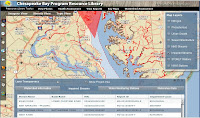 Relating to water issues, another demonstration featuring the Flex API was for the Chesapeake Bay Program: http://wdcb10.esri.com/cbprl/
This showed use of federated assets, such as USGS stream gauges, USEPA STORET water quality data, and so on, and provides many tools for assessment, management and best practices for improving water quality for the Chesapeake Bay.
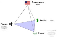 Colonel Alex Dornstauder of the US Army Corps of Engineers gave a good presentation on what USACE is doing relating to watersheds and water quality, using an approach of "3D decision space" and cross-agency "lenses". The approach utilized several different datasets and attributes with ModelBuilder to get a baseline assessment, which can then be utilized to in the target, with a collaborative vision to triage risk and prioritize investments to water quality.
(3d Decision Space image gleaned from a related presentation by Col. Dornstauder: http://gis.esri.com/library/userconf/ieug08/papers/watershed_dornstauder.pdf)
The Colonel closed with an excellent quote from George Washington, "Let us raise a standard to which the wise and honest can repair"
There was also discussion and demos of
- Situational Awareness tools built on the Flex API in the code gallery (http://resources.esri.com)
- ArcGIS Mobile SDK, with a demonstration, showing field data collection, domains, subtypes, dropdown list support.
- 3D and network analysis - modeling of movement within a building in 3d (pedestrian egress via stairs, et cetera) - 3D proximity analysis
- There was discussion of food safety, with a case study of the Hawaii Food Safety Center
- Economic security and urban growth
- Demonstration of ordinary least squares analysis vs. geographically weighted regression
 Maryland Governor Martin O'Malley gave an excellent discussion, hitting many excellent notes - with many things that resonated: "can you show me my house" - which he tied in well in how "show me my house" repeatedly resonated in context of geography with the many case studies he presented. Other highlights "Maryland is ESRI Customer #008" -
He discussed trying to remedy many of the issues facing Baltimore, "hopeless & vacant hearts" and how CityStat http://www.baltimorecity.gov/government/citistat/ and iMap http://maps.baltimorecity.gov/imap/ have provided far more performance-oriented approaches - he touched on how previously, information had been collected in such a way as to not make it to management in any meaningful way, with emphasis on measurement of inputs, but not of outputs and outcomes - and the new paradigm of viewing outcomes against the map, tells where challenges lie. These types of geospatial approaches allow relentless followup and assessment, and drive the effort to move the graphs in right direction, with improvements in city services, reductions in shootings and homicides, improved response times - cleaning out and boarding of vacant houses, mapping service problems and opportunities for daily review. "The map does not care if neighborhood is white/black, rich/poor, republican/democrat"
As Governor now, he has taken this mapping-oriented and performance-oriented approach to the next level on a statewide level, with StateStat http://www.statestat.maryland.gov/ and BayStat http://www.baystat.maryland.gov/, and GreenPrint, which provides an ecological assessment of every single parcel in Maryland, along with ecological measures being put in force: http://www.greenprint.maryland.gov/ - and tie-in of stakeholders at all levels - "if it's not about the relationship, it's not about anything".
Governor O'Malley left the audience with a Native American proverb, "how we treat one another is reflected in how we treat the earth"
 I did visit the EXPO floor and looked at some of the maps - the floor was definitely quite crowded. By one account, there were 2800 registrants this year for the ESRI Federal User Conference.
Some of the ESRI schwag:

(I don't think the DevSummit attendees will be getting ESRI umbrellas to go with their weather...)
As posted previously, I will try to live tweet more coverage tomorrow, using hashtag #feduc
If you are also attending and want to meet up, by all means, drop a line - dsmith (at) synergist-tech.com - while I have a few meetings, both inside, during FedUC, and a few outside meetings in the DC area next week, I will generally try to make FedUC my base of operations and will blog wherever conditions permit (if conference WiFi is available and/or my AT&T 3G service cooperates).
Also, I will try to post updates from my phone and laptop via Twitter - http://twitter.com/DruidSmith using the hashtag #feduc - if others are attending, I'd suggest using #feduc as well, tools such as TweetGrid will be helpful for tracking twitter traffic in realtime - here's a sample 1x1 TweetGrid already set up for tracking #feduc: http://tweetgrid.com/grid?l=0&q1=%23feduc


Informative conference.Got lots of informations about GIS and its related stuffs!!Thanks for sharing.
regards
Geospatial services
Thanks Dave for posting this.
HALO ! SAYA GURU GEOGRAFI DARI INDONESIA,MAU BELAJAR BLOG DAN GIS PADA BAPAK.
hi..i'm didiey from malaysia..
i'm the student of geomatic engineering..
keep updating your blog!
it might be useful for my assgment
;)
I'm a novice just beginning to appreciate the wonders of GIS mapping. Are you aware if any good GIS maps that identify brownfields and environmentally contaminated land? I am particularly concerned with low-income urban neighborhoods. Great blog bytw.
hi im hanif from malaysia. currently im working at IT company doing the GIS web page wif Esri Malaysia. Just want to let u know i'm ur blog follower hehehhe nice blog lot of knowledge i got from here....