Recently one of my little side pursuits has been playing with OpenStreetMap. I had tinkered with it a little bit some time ago, and decided to revisit it.
For those who have not yet looked at OpenStreetMap, it is an open mapping framework, which utilizes public domain and crowdsourced data: http://www.openstreetmap.org/
Currently, there are a number of excellent tools available for working with OSM, such as the Potlatch web editing environment (within OSM, click on the 'edit' tab and away you go - it provides basic tools for adding points of interest, moving and deleting items, and adding attributes to existing points...
For a quick start, help information is available via a wiki here: http://wiki.openstreetmap.org/wiki/Main_Page
With regard to other tools for editing OSM, I've been using Merkaartor in a Windows environment - http://www.merkaartor.org/ - several other users use a Java tool, JOSM - http://josm.openstreetmap.de/ - they both appear to have comparable feature sets.
Potlatch also provides some basic aerial photos, however Merkaartor and JOSM also allow users to work with WMS services, ESRI shapefiles and other sources of data toward fast digitization and capture of data.
On committing editing changes, new tiles are rendered rather quickly, allowing OSM to allow rapid development of base maps. Many people are also using GPS for track logs, which can then be uploaded to OSM as GPX to facilitate capture of trails and unmapped streets.
In many places, OSM is being used to create maps where there previously were none, such as in developing countries - this might serve efforts such as Engineers Without Borders - and I plan to revisit some of the GIS data I've collected up for places like Cameroon and Rwanda on behalf of EWB and look at getting it posted to OSM where appropriate.
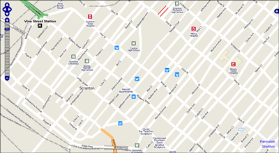
Locally, I have been playing with the mapping for my own town - I found that it essentially just had some older TIGER data and Points of Interest (POIs) from USGS Geonames (GNIS). The road network came up jagged and inaccurate, many features missing, outdated and so on. Here's where local knowledge and feet on the ground comes into play in crowdsourcing.
I essentially started out with something that looks like this:
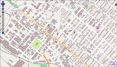
 And have quickly been going to something that looks like this:
 Here, I've been using orthophoto WMS services and other datasets for correcting streets and railroads, digitizing streams, putting in building footprints, parks, trails and amenities, and in just a short time am rapidly going to a useful and reasonably attractive map (note that this is still in progress). Further, the data can also be reused in a variety of ways, such as in Open Source routing services, using custom styling and symbology and so on.
I would highly encourage others to take a look and play with it: http://www.openstreetmap.org/ - however, with the caveat that it can be addicting...


