Surveying, Mapping and GIS

Exploring all aspects of mapping and geography, from field data collection, to mapping and analysis, to integration, applications development and enterprise architecture...

  • Geospatial Technology, End to End...

    Exploring all aspects of mapping and geography, from field data collection, to mapping and analysis, to integration, applications development, enterprise architecture and policy

Happy New Year

Posted by Dave Smith On 12/31/2005 10:07:00 AM 0 comments


Wishing everyone a Happy New Year. Was a busy week, with a blur of holiday and celebration - from Christmas, to my son's birthday yesterday, to finally collecting on a long-overdue invoice, to New Year's Eve today. Already got greetings from 2006 from my friends Down Under...

2005 came with mixed blessings- much to be thankful and rejoiceful for, but 2006 is looking absolutely SPECTACULAR.


Regards,

Dave Smith

GIS to the rescue

Posted by Dave Smith On 12/31/2005 08:23:00 AM 0 comments

The Free-Lance Star of Fredericksburg, VA reports how a man slipped in the woods, getting a head injury and suffering from memory loss. The man was fortunately able to dial 911, where the dispatchers were apparently able to partially find his position from cell tower signals. In describing his surroundings, the caller said he could hear running water and traffic, which narrowed it down to within a hundred yards on the dispatchers' GIS base map.

The article does not go into any further discussion about E911 implementation - E911 is geared to work in two phases - the first being to allow location within the nearest tower, within it's "cell", the second phase being to allow location within 50 to 300 meters. By signal alone, this is similar to resection in surveying- a combination of signal strength and signal timing to get relative distances from multiple towers, which can then be intersected, provided enough towers can communicate with the cell phone- just as how GPS works by computed distance from multiple satellites... Often the term triangulation is bandied about, but triangulation refers more to three (or more) directions, as opposed to three (or more) distances.


Add to this, ability to ping cell phones with on-board GPS in emergency situations in a full E911 implementation.

Something interesting that I found was a Google Maps implementation that shows cell tower locations (although not necessarily comprehensive), given a location: http://www.cellreception.com/towers/index.html


Technorati tags:
, , , , , , , , , , , , , , , , , , , , , ,

Hopping to Kazakhstan...

Posted by Dave Smith On 12/30/2005 10:22:00 PM 1 comments

KazCosmos, Kazakhstan's National Space Company announced today they are going to be launching their own remote sensing satellites, along with GPS satellites, by 2011-2012. They plan to invest $400M into satellites and their space infrastructure over the next few years.

As home to Baikonur and the space complex, it makes sense...


Technorati tags:
, , , , , , , , , , , ,

India eyes up satellite payloads as a new market...

Posted by Dave Smith On 12/30/2005 09:53:00 PM 0 comments

This article in India's Central Chronicle discusses possible lifting of technology sanctions by the US and a booming market in India for deploying satellite payloads, particularly for remote sensing. Aside from general success marketing to a broad satellite clientele in the EU, the article highlights remote sensing applications via a leading Indian firm, Antrix, which has been marketing India's IRS imagery in conjunction with Space Imaging. Additionally, mention is made of Antrix securing a contract with Singapore to launch it's X-sat remote sensing vehicle.

Indian IRS Imagery after Tsunami
On a related note, India's New Kerala reports that India's IRS-1C satellite is celebrating a decade in service, having been launched on December 28, 1995. Above is imagery from the IRS-series, which was used, among other things, for assessing damage after last year's deadly tsunami.


Technorati tags:
, , , , , , , , , , , , , , ,

Chinese National GIS Takes Shape

Posted by Dave Smith On 12/30/2005 09:27:00 PM 0 comments


The People's Daily of China reports today that the Digital China Geospatial Information Fundamental Framework has taken shape, consisting of "four databases and one archive", containing geodetic, remote sensing, image, cartographic and special-subject databases and one surveying-mapping archive.

The article doesn't go into much more detail beyond this, other than to state that this framework is a geospatial RDBMS, containing "1:4 million, 1:1million, 1:250,000 and 1:50,000 national fundamental geographic databases and a 1:10,000 digital elevation database for the key flood-control areas of seven big rivers in the country".

As what looks like a newly emerging national GIS for China, it is impressive at least on a geographic scale. I am curious about the architecture, whether this took shape centrally or in a distributed/federated form, what infrastructure they are using (i.e. SDE, Oracle Spatial, other), for that matter proprietary or open-source, how they make it available (flat files versus ArcIMS image or feature services, or web mapping, or SOA / XML web services (OGC or otherwise)... How do they treat metadata, interoperability and standards...

I wish congratulations to the chinese government, but as a GIS technocrat who also dabbles in (and struggles with) agency enterprise architecture issues, I have many questions...


Technorati tags:
, , , , , , , , , , , , , , , , , , , , , , , , , , , , , ,

GPS Limited in 2006 Dakar Rally

Posted by Dave Smith On 12/30/2005 01:15:00 PM 0 comments


I found this interesting- According to CNN, the use of GPS will be limited in the 2006 Dakar rally, to go back to more traditional navigation techniques. Historically, this race has had vehicles manned by a driver and co-pilot, and part of the test of human and mechanical endurance was the test of being able to traverse the often challenging puzzles presented by the landscape.

Since 1978 this race has been run- This year, it kicks off starting tomorrow, December 31, 2005, and traverses over 9,000 km, from Lisbon through the most rugged terrain of the hinterlands of Portugal, Spain, Morocco, Mauritania, Mali, Guinea and Senegal.


The progress can be tracked online at the official site.

Do I take it that this means we won't be seeing any endorsements of Galileo from the Dakar organizers?


Technorati tags:
, , , , , , , , , , , , , , , ,

Galileo / GIOVE-A

Posted by Dave Smith On 12/29/2005 01:21:00 PM 0 comments


To follow up on my previous article Surveying, Mapping and GIS: Russian Christmas (GLONASS), the EU's first Galileo component, the GIOVE-A vehicle has been successfully launched...

Congratulations to the ESA team, and it will be interesting to see how things unfold. When I lived in Germany, my house was in a small town called Weiterstadt, which was near Darmstadt in Hessen (Central Germany), where the European Space Operations Centre (ESOC) resides... We had a few friends who worked for ESOC.


Technorati tags:
, , , , , , , , , , , , , , ,

Blog content...

Posted by Dave Smith On 12/29/2005 11:54:00 AM 0 comments

Adena Schutzberg at Directions Magazine / All Points Blog discusses a phenomenon of blog aggregators and content stealing... It seems this is controversial in some areas, but her take on it, aside from the core copyright infringement issues, is partly "fuggettaboutit", in that that serious folk will go directly to the source anyways...

I have a slightly little different of a take on it... There's plenty of sources for geospatial news, and aggregators capture it all on the fly. For people who might not have an RSS reader, the benefit is that they can go to one of these aggregator sites and quickly skim the headlines for articles of interest, as opposed to going to each site individually. The geospatial industry is a pretty broad spectrum, soup to nuts. Some folks do cover a considerable breadth, whereas some go very deep within a specific area. Additionally, some blogs, like mine, often go outside of "strictly GIS", to present opinion on other topics, such as surveying, GPS and other allied areas.

If an aggregator site is just capturing feeds and presenting them with no pretext, I have no problem with that, as I typically follow it to the source for anything of interest. On the other hand, separate from the automatic feed aggregator sites, it seems like there are a few blog sites out there that I have come across that frequently either just reprint in entirety, or present a link "here's an interesting article about x", without any analysis, reaction, response, commentary or any value added whatsoever. I tend to view blogs as something that should add substance to the fabric of the geospatial community, and not just parrot things on other sites.

As a side note... Adena was teaching assistant for one of my favorite courses back at Penn State- Spatial Analysis I and II, taught by the late Professor Gould- one of the best professors I ever had.


Technorati tags:
, , , , , , , , , , , , , , ,

Tax Map versus Survey...

Posted by Dave Smith On 12/29/2005 11:08:00 AM 0 comments

The Pittsburgh Tribune-Review reports a sticky lawsuit over an eminent domain case, where the South Allegheny School District had taken a man's land by eminent domain, and paid the wrong family- based on errors in the tax assessment system.

Evidently, there were misnumbered lots on a plat, compounded by a propagation of error when the county re-drew the map. As a result, the tax map system had the wrong owners shown, who were apparently compensated $80,000 by the district.

The county is planning to go to a GIS-based system, but the question and doubt remains as to how many faulty property lines and how much erroneous ownership data is propagated from map to map, and carried over into GIS-based tax assessment systems.

Typically, from what I have seen, tax mapping GIS systems are often digitized/rubbersheeted from old hand-drawn maps, or 1"=400' scale or worse. Additionally, much of the work, whether manual or GIS-based, is performed without the benefit of thorough analysis, input or research of deeds, ownership and boundary data.

It's disturbing on many levels- first the School District should have done its due dilligence to verify the parcel and its ownership. Also, Cadastral GIS systems tend to be a pet peeve of mine- It's another example of where domain expertise and GIS expertise need to come together, lest they simply become a system to generate pretty maps that only get people in trouble.


Technorati tags:
, , , , , , , , , , , ,

How NOT to mark a point

Posted by Dave Smith On 12/29/2005 09:40:00 AM 0 comments

Survey VandalismI found this image online, some serious geotagging by a surveyor...

It's an example of unprofessionalism and what not to do. If it's a temporary mark, lumber crayon or chalk works, and will be more easily removable... If the mark is to be permanent, a more subtle approach can suffice...

Some pundits suggest... if you're going to go hog-wild, schlobbering paint all over, why not go all out, and at least also provide adequate metadata such as error ellipses, horizontal and vertical datum?

At least the smiley-face (may have been a note of sarcasm from the surveyor) was covered up....


Technorati tags:
, , , , , , , ,

Landscape Archaeologists

Posted by Dave Smith On 12/28/2005 12:10:00 PM 0 comments

Ancient Egyptian SurveyorsSmithsonian Magazine is running an article discussing the use of aerial photography in teasing out details of historic land use and man-made features, that may have become obscured over the years... The individuals who are pursuing this area of study are referred to in the article as "landscape archaeologists".

In many ways, surveying and archaeology are closely related, in using historic documentary references to land ownership and retracing and relocating historic evidence of possession in the field. Point of Beginning Magazine (POB) has run several articles in the past of the use of aerial photography to reconcile lines of property ownership.


Technorati tags:
, , , , , , , , , ,

Mapserver Foundation

Posted by Dave Smith On 12/28/2005 10:43:00 AM 0 comments


I welcome the unveiling of the Mapserver Foundation, hopefully it will be a boon to the open source GIS community. However, I still think the key for success of any program is not necessarily open source, but open architecture, along with well-defined, practical and workable standards. It will be interesting to see how things work out with Autodesk's backing.

I do not wish to detract from the open source community, but in many instances it seems open source has become an almost religious movement, with many efforts appearing to be just for sake of promoting open source alone. I on the other hand am a pragmatic individual, I tend to not believe in reinventing the wheel until it needs reinventing. With the new directions heading toward Common Operational Picture (COP) and Service-Oriented Architecture (SOA), the landscape becomes an interwoven fabric of interoperable data, metadata, component-based and services-based GIS.

In this vision, as things progress the back end, which provides data, metadata, analytical functions, map rendering, and other services, becomes increasingly transparent and platform/vendor independent. I believe that this is the ultimate direction that should be pursued, to a point of mix-and-match, plug-and-play interoperability.


Technorati tags:
, , , , , , , , , , , , , , , , , , , , , , , , , , , ,

Leap!

Posted by Dave Smith On 12/27/2005 02:23:00 PM 0 comments


To reconcile the difference between Coordinated Universal Time (UTC) kept by atomic clocks and the earth's rotation, a leap second is being added on December 31, - On New Year's Eve, 2005, the clock will tick 23:59:59... 23:59:60... 00:00:00. The insertion of leap a leap second compensates for the very gradual deceleration of the earth's rotation. Since 1999, the accumulated differential is one second.

How does this affect GPS? According to the US Naval Observatory, GPS is not adjusted for leap seconds, and operates in the Epoch of January 6, 1980. As of New Year's Eve, GPS will be ahead of UTC by approximately 14 seconds.

Some historic leap seconds since 1980 are as tabulated as follows:

1980 JAN 1 =JD 2444239.5 TAI-UTC= 19.0 S + (MJD - 41317.) X 0.0 S
1981 JUL 1 =JD 2444786.5 TAI-UTC= 20.0 S + (MJD - 41317.) X 0.0 S
1982 JUL 1 =JD 2445151.5 TAI-UTC= 21.0 S + (MJD - 41317.) X 0.0 S
1983 JUL 1 =JD 2445516.5 TAI-UTC= 22.0 S + (MJD - 41317.) X 0.0 S
1985 JUL 1 =JD 2446247.5 TAI-UTC= 23.0 S + (MJD - 41317.) X 0.0 S
1988 JAN 1 =JD 2447161.5 TAI-UTC= 24.0 S + (MJD - 41317.) X 0.0 S
1990 JAN 1 =JD 2447892.5 TAI-UTC= 25.0 S + (MJD - 41317.) X 0.0 S
1991 JAN 1 =JD 2448257.5 TAI-UTC= 26.0 S + (MJD - 41317.) X 0.0 S
1992 JUL 1 =JD 2448804.5 TAI-UTC= 27.0 S + (MJD - 41317.) X 0.0 S
1993 JUL 1 =JD 2449169.5 TAI-UTC= 28.0 S + (MJD - 41317.) X 0.0 S
1994 JUL 1 =JD 2449534.5 TAI-UTC= 29.0 S + (MJD - 41317.) X 0.0 S
1996 JAN 1 =JD 2450083.5 TAI-UTC= 30.0 S + (MJD - 41317.) X 0.0 S
1997 JUL 1 =JD 2450630.5 TAI-UTC= 31.0 S + (MJD - 41317.) X 0.0 S
1999 JAN 1 =JD 2451179.5 TAI-UTC= 32.0 S + (MJD - 41317.) X 0.0 S
2006 JAN 1 =JD 2453736.5 TAI-UTC= 33.0 S + (MJD - 41317.) X 0.0 S


Technorati tags:
, , , , , ,

Developers Wanted

Posted by Dave Smith On 12/26/2005 10:44:00 PM 0 comments

Synergist Technology Group, Inc. currently has multiple openings in the Arlington, VA area for IT work relating to environmental and geospatial applications.

Positions include:

  • Portal Developer - Java Portlets/Oracle IAS
  • Web Services Developers - J2EE Environment
  • GIS Database Administrator - ArcSDE, Oracle Spatial
  • Lotus Notes / Database Administrator
  • Engineering Planner (Software)
  • IT Program Manager
  • IT Analyst
  • Programmer Analyst (Documentum)
  • Programmer Analyst (Business Intelligence)
  • Systems Architects
  • Software Development Analyst (ERWIN, PL/SQL, Oracle, CMM/CMMI)

Also looking for Chemists and Research Scientists for Las Vegas, Nevada - Environmental Science and Investigation (GC/MS and other methods)

If you or anyone you know might be interested - contact me at dsmith@synergist-tech.com


Technorati tags:
, , , , , , , , , , , , , , , , , , , , , , , , , , , , , , , , , , ,

Russian Christmas (GLONASS)

Posted by Dave Smith On 12/26/2005 02:31:00 PM 0 comments

GLONASS SatelliteRussian media brings news from the Baikonur space complex in Kazakhstan of the successful launch of three new GLONASS space vehicles aboard a Proton-K launch vehicle. This will bring the complement of GLONASS SVs to a GPS constellation well over half of the target 24.

Russian president Vladimir Putin has further announced that he wants to see completion of this russian GPS system by 2008.

Although the two systems are not completely interoperable, combined GPS+GLONASS receivers are available from a number of leading manufacturers. The continued launching of the GLONASS program and it's support by President Putin will be a boon to surveyors using GPS+GLONASS systems here in the United States, and will provide additional availability for added possibilities, to allow increased visibility and availability of SVs.

Meanwhile, another system to keep an eye on is the European Galileo effort. A test vehicle as part of the Galileo effort is being launched at Baikonur tomorrow, according to the Independent. This vehicle, 'Giove-A' or 'Galileo In-Orbit Validation Element A' will establish a testbed and will reserve the allocated region of frequency spectrum for the Galileo effort. Ultimately, the Galileo program will establish a constellation of 30 SVs, going into service in 2008 and expected to be fully operational by 2010.


Technorati tags:
, , , , , , , , , , , , , , , , ,

Yule...

Posted by Dave Smith On 12/24/2005 11:46:00 PM 0 comments

Wishing everyone a happy holiday and joyous yuletide season!

ESRI Service Packs for ArcGIS 9.1 Family

Posted by Dave Smith On 12/23/2005 01:14:00 PM 0 comments


ESRI's website announces:

ArcGIS 9.1 Service Pack 1 Now Available

The ArcGIS 9.1, ArcSDE 9.1, and ArcIMS 9.1 Service Packs contain performance improvements and maintenance fixes.


Technorati tags:
, , , , , , , , , , , ,

Bob Plumb is out of plumb...

Posted by Dave Smith On 12/23/2005 10:57:00 AM 0 comments

Popular surveying site Bob Plumb (http://www.bobplumb.com) says good bye... hopefully just for the moment. My understanding is that the founders have been tied up with other things, and at one point were negotiating with other parties for taking over stewardship of the site.

Apparently the wires have been crossed and at this point the domain has lapsed, and the fate and future of Bob Plumb is unknown.


Technorati tags:
, , , , , ,

Geospatial Portals

Posted by Dave Smith On 12/23/2005 08:52:00 AM 3 comments

With apologies to Gilda Radner's "Emily Litella" character from the classic SNL, "What's all this fuss about Geospatial Portals"?

Of late, left and right I have been running into portals and folks talking about portals. Problem is, everyone seems to be talking about something different from the next person.

In most instances the GIS analyst community is talking about portals in terms of a gateway to geospatial data and services, ala the Geospatial One Stop (GOS) portal, whereas some GIS developers are instead talking about portlet-based geospatial applications, and some are talking about varying combinations of the two, drawing on the portlet-based implementation of the GOS2 version versus the ESRI GIS Portal Toolkit (GPT)...

Even when we are talking about portlets, the discussion varies, with competing platforms like IBM Websphere and Oracle IAS even running side-by-side within the same enterprise, though with different applications. Sure, people suggest that Java-based portals and the JSR-168 standard for portlet-to-portlet communications make things interoperable, but the realities are still far from concrete. At risk of incurring the wrath of the Open-Source J2EE community, I have to say that even these have their not-insubstantial issues when it comes to platform, infrastructure and interoperability. Thank the Gods for XML and Web Services.

Certainly tools like the Oracle Portal Developer Kit (PDK) claim to offer quick portlet-enabling of legacy applications, via web clipping- where this is nice for some applications, however the reality is there are no guarantees and as a bare minimum, the JavaScript typically needs to be reworked. For nice GIS UI features, like rubber-band zooms, the hope is that the JavaScript can be saved to some extent and re-applied in the portlet implementation. Additionally, if going to a "sexy" new portlet-based look and feel, this presents the opportunity to look at AJAX and web services...

So in the meanwhile, portlet-based implementations of slick or robust GIS applications may not yet be there.

I think portals and portlet development have come a long way, but I think a true fusion of GIS, AJAX and SOA is still to come from intrepid developers.


Technorati tags:
, , , , , , , , , , , , , , , , , , , , , , , , , , , , , , , , ,

Mobile GPS, Gizmos and Gadgets

Posted by Dave Smith On 12/22/2005 08:33:00 PM 0 comments

As I have been spending a lot of time in stores of late for the holiday shopping season, the stores abound with all kinds of nifty new widgets and gizmos- one of which is the dashtop moving-map GPS units. These, along with MP3 players still have me puzzled.

NEC MobileProI've been a user of PDAs going back to around 1998, where I had an NEC MobilePro 400 running Windows CE. I still have the MobilePro, and loved the wide screen and Pocket Excel and Word, along with the fact that it could take standard AA batteries.

A couple of years later, I got a Philips Nino 510, one of the first Windows CE-based units to come out with a color screen. Philips NinoThe trusty Nino lasted me almost 5 years before one fall too many finally caused the screen to go. In fact, though I am hardly a trendsetter, I had been enjoying MP3s and other modern pleasures with my Nino for years before the iPod craze even caught on.

I now run an HP iPAQ rx3115, with integrated Bluetooth and Wi-Fi, to serve a wide variety of everyday tasks, including mapping. We have also recently developed an application based on the EPA EnviroMapper family optimized for handheld PDAs, which uses ASP.NET, ArcIMS, ArcWeb Services for base mapping and geocoding, GlobeXplorer imagery, and the EPA EnviroFacts database for facilities data. HP iPAQ rx3115One of the things that comes to mind is integration of GPS into this type of application.

With the advent of Bluetooth and other technologies, it becomes a no-brainer to integrate GPS into mobile applications. This returns to the original question- the fancy dashtop GPS units selling for $900 at Best Buy and all of those favorite technology haunts. For just over a third of that price, one can equip ones self with a nice PDA, a bluetooth GPS unit and software, and perhaps even an FM transmitter and have a rig that will suit your vehicle for navigation and MP3 entertainment needs, as well as all of the other niceties that a modern PDA provides- email, contacts, calendars, to-do, calculator, Excel, Word, voice recorder, et cetera. For a guy like me who spends many hours on the road (even my regular four-hour ride from Northeastern Pennsylvania to Washington, DC alone).

As a little aside, I am a direct descendant of the man after whom Bluetooth is named- King Harald Blåtand (AD 911-987), son of Gorm the Old. Harald, also known as King Harald I, united Denmark and Norway. Bluetooth technology, spearheaded by several Scandinavian firms, is in turn viewed as a uniter, much as King Harald was. Incidentally, Harald didn't actually have blue teeth, but was indeed rumored to have an affinity for blueberries.


Technorati tags:
, , , , , , , , , , , , , , , , , , , , , , , , , , , , , , , , , , , , , ,

Is GML a format?

Posted by Dave Smith On 12/22/2005 02:58:00 PM 0 comments

I came across a post on a blog called Geoweb- the site appears to have a lot of discussion of Geography Markup Language (GML) and OGC standards. Of interest was a particular discussion about if GML is a "format". There were a number of philosophical points and comments by others, some of which were to the point of "GML is not a format" and "convert from GML and convert from GML is meaningless".

This post was very interesting, and I had a number of mixed reactions to it, mainly from the standpoint of having actually developed an OGC-compliant Web Feature Service (WFS) service from the ground up earlier this year. What we found was that there were a lot of people talking about GML and WFS, with no lack of detailed technical and philosophical discussions, but where the rubber meets the road, in terms of actual applications, they were precious few. A lot of vaporware abounded, so it seems. It also gave me a lot of appreciation for all of the hard work that people at OGC, The Carbon Project, Juan Chu Chow at Safe Software, and others had been putting in on making GML and WFS a reality.

In terms of our own reality, we rapidly came to the conclusion that a subset of GML, containing the essential data we were conveying was adequate and appropriate. The full GML schemas tend to include a lot of items that, while great to consider, aren't always appropriate for all data, and the schemas were complex, with multiple hierarchical and interlinked subschemas, to the extent of even arriving at one unified schema became difficult using the tools we had. So ultimately we took the dataset elements that we had and mapped them to a new unified schema that mapped as a subset to the full GML schemas. So in a sense we did "convert to GML". But WHAT GML? This again is where it becomes essential to have a schema...

From here it becomes a much simpler matter- making this GML data available to the client, and enter Web Feature Service (WFS). A basic (nontransactional) Web Feature Service has three basic methods: GetCapabilities, which provides the client with basic information about the service- in our instance we were performing a dynamic query of an Oracle database and presenting the matching feature services as WFS "layers", which would then be listed for selection by the user within the client. Next comes a call to the DescribeFeatureType method, which simply presents the schema to the client for validation. Finally, we have the query itself, the GetFeature method, which accepts the query parameters and returns the GML for the matching features. The proof of concept for our WFS, believe it or not, was coded, along with two test harnesses in one morning in .NET...

Initially we didn't have access to any existing tools for testing this service- we quickly latched on to the Carbon Project tools: CarbonViewer and Gaia... Here we began to notice that WFS and GML implementations were a little different, even between CarbonViewer and Gaia. The primary enterprise GIS tool in this instance was ESRI - ArcGIS and ArcIMS, and a few, myself included, felt that with all the buzz about GML and interoperability, getting the GML into ArcGIS would be no problem. Well, yes and no... The first snag was that Data Interoperability Extension is not, by default, included in the ESRI Enterprise License Agreement- partly due to their internal arrangements with Safe Software, who provides the engine that Data Interoperability Extension runs on. But ultimately this too was resolved, bringing us to the the next issue- subtleties between how FME and Data Interop Extension handle GML and WFS, and nested tags within the GML, as compared to the Carbon products. This also was ultimately resolved, the temporary but surprisingly effective quick fix being an XSLT transform on the fly within the service.

So ultimately, IS GML a format, or is it not? Even having been there, I would still say, yes and no. GML ultimately will probably never be a form for native storage of data, but will continue to exist as a format for transmission and interoperability of data, and in doing so, data does take the shape of GML- however as we are still finding that GML vaporware still outnumbers the small, but increasing number of real-world solutions, it may be that people will at least for a little while consider it to be more of just a specification or guideline, subject to interpretation. I however think its a good and workable start. There are hurdles, but it is very real and very workable.

At the recent EPA Environmental Symposium in Las Vegas I had occasion to bump into Sam Bacharach from OGC to report to him that the project was a success- I had last seen Sam in the spring at the Pennsylvania Digital Government Summit, prior to beginning the project- we had also opportunity to use the fruits of our labor to help out with Hurricane Katrina recovery efforts, as our WFS service allowed some measure of dynamic drilldown, not otherwise available in the available map services.

The limitations that we did encounter were unfortunately beyond our control, limitations in the Oracle database backend structure, which created too much spatial granularity (we couldn't query large geographic areas effectively), and on the other hand not enough granularity to allow drilldowns to very specific facility types, such as querying by NAICS/SIC codes.

In the end, we were pleased and honored to have been able to do our part for Hurricane Katrina relief in terms of applications support, along with our GIS analysts serving in the EPA Emergency Operations Center in Washington, DC to provide maps for presidential and congressional briefings and support for development of the Enviromapper for 2005 Hurricanes application. We still have that database backend redesign slated, and at some point would like to discuss the possibility of OGC certification. Currently our partner on this contract, Lockheed-Martin is listed as an OGC partner, and Sam Bacharach tells me OGC has been working very closely with LM of late.


Technorati tags:
, , , , , , , , , , , , , , , , , , , , , , , , , , , , ,

Land Surveying and Metadata

Posted by Dave Smith On 12/21/2005 09:57:00 PM 3 comments

In a recent discussion on RPLS.COM, the question came up about coordinate conventions, PNEZD or PXYZD, and so on. Many surveyors still tend to use the convention of Northing (y) and Easting (x), based on how coordinates were traditionally computed using the method of latitudes and departures.

Northing/Easting (Y/X) however tends to be counterintuitive to mathematicians and many GIS applications, which are used to basic cartesian conventions of x,y. This tends to lead to one level of confusion. Similarly, surveyors often deal with geodetic coordinates, such as latitude/longitude, again a y/x convention- which one must be mindful of even when converting to other coordinate systems.

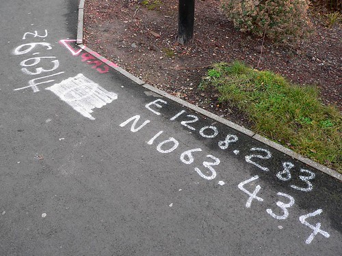
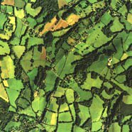
So suppose we have a simple ASCII file, containing (fabricated data for sake of illustration):

31,45039.6774,77239.7662,1601.334,FND IP
32,45118.3378,77988.9965,1607.232,FND DH
33,45968.2388,77543.6557,1607.937,IP SET
...
What exactly does this mean? For many surveyors, used to convention, they might assume it is P, N, E, Z, D (point number, northing, easting, and descriptor) However, how do we know x and y are not reversed? And this is still in the context of basic plane surveying- everything is relative to an imaginary 2-d cartesian plane.

In some instances, the answer to what the values represent may be (or at least seem) evident- if for instance state plane coordinates(SPC) coordinates are used, and the surveyor is familiar with the range of values, he may visually be able to validate them generally. But again, guesswork is involved.

Let's add some dimension of dimensionality... what coordinate system are we talking about? What datums, horizontal and vertical? Or... to add another wrinkle, enter GPS-derived and geodetic coordinates, such as latitudes and longitudes- what assumptions were made there? Or to add yet another layer of dimensionality- we can talk 4-D coordinates, with ITRF and vectors representing crustal motion and other factors over time. These things enter more and more into the vernacular of the modern land surveyor.

I think ultimately this type of metadata, can lead toward ever increasing usability and interoperability of survey data- and ultimately standards-based systems, such as OGC GML and tags such as EPSG spatial reference system (SRS) tags may go a long way toward promotion of more seamless ways to integrate data from disparate sources, from the 2-d plane surveying data all the way to high-end data without losing the fidelity, meaning and context of the data.

Technorati tags:
, , , , , , , , , , , , , , , , , , , , , , , , , , , ,

VETS GWAC

Posted by Dave Smith On 12/20/2005 02:03:00 PM 6 comments

Much to our dismay, we received notice that we did not make the cut for the VETS GWAC contract. Surprisingly, their rationale was on a completely inconsequential technical detail- the spreadsheet that we submitted rates on. There were two spreadsheets on this to complete, both essentially the same, listing contract line item position categories and hourly rates, which are then carried from year to year with escalators.

The first spreadsheet covered the base years, the second additional years. For the first we were asked to submit an escalator, to cover price increases year-to-year. The second, for subsequent years, would follow the same rationale and methodology. The issue evidently was that we filled in the escalator for the second sheet. GSA says they were going to fill that in for us.

A.) The same escalator was used by us and
B.) There was absolutely nothing precluding GSA from entering any escalator they like, as they would have anyways.

As a result of this inconsequential nonsense, we along with a consortium of over a dozen other Service Disabled Veteran Owned Small Businesses are going to lose out on potential opportunities, not to mention the tremendous investment of time that we put in on the effort to prepare our proposal.

Needless to say, we are going to protest. It seems the fine ladies and gentlemen at GSA have missed the point of this exercise, which was to help small businesses, and to help the disabled vets who sacrificed for their country, as opposed to limit and restrict them with nonsense. Particularly after they allowed a number of other businesses to submit their proposals after the solicitation had already closed. I would think that missing the submittal deadline would be a far more substantial breach than this.


Technorati tags:
, , , , , , , , , , ,

Technorati Tags

Posted by Dave Smith On 12/19/2005 09:41:00 PM 16 comments

The folks at Technorati have been working toward leveraging the blogging community through the use of tags and aggregation... After playing around a little trying to do the HTML these tags manually, I finally got fed up enough with the tedium to cook up my own little tool. What's more, I'm making it available for anyone else to use.

The app is a simple little .NET application, that on first use creates a little ASCII file, "tags.txt" that you can add your own favorite tag categories to... after adding your tags, press "generate" and it will generate your HTML for you. Additionally, you can add and remove tags using the tool, or if you prefer, import the tags into tags.txt using notepad or a suitable ASCII editor. The tags.txt file will be maintained sorted in alphabetic order, should you want to use other tools with it.

The screenshot to the right shows it in action...

You can download it at the link below... FREE, but remember where you found it...

License terms- I make this available for personal use, but reserve all rights beyond this. I'm no expert on licensing terms, I mainly ask that if you want to to modify or use this app outside of its intended use, drop me a line and we can discuss.

************************************************************

August 14, 2006 UPDATE: The terragrafix.net server has been
having some issues - I have uploaded a copy of the tool here:


http://www.synergist-tech.com/tools/TechnoratiTagger.zip

************************************************************


Technorati tags:
, , , , , , , , , , , , , , , , , , , , , , ,


Wiki, wiki...

Posted by Dave Smith On 12/18/2005 05:08:00 PM 0 comments

Having used Wikipedia on occasion in the past, my reaction has ranged across the entire spectrum, from either impressed at how well the Wikipedia entries have been written, researched and presented, or dismayed at the lack of anything.

I was recently listening to a story on NPR's All Things Considered, where the articles in Wikipedia were assessed, and even compared to Encyclopædia Britannica for content- and the finding was that Wikipedia was in fact quite comparable in terms of technical content and accuracy.

After a little consideration, of course it sinks in that this is indeed a flourishing collaborative project, the success of which depends on active participation and contribution. So, I've started to put in my humble $0.02, wherever possible.

Helping out in the community- at least until the next, brighter and more knowledgeable guy comes along, and I'd encourage everyone else to do the same in their fields of knowledge. Wikipedia looks like it's becoming a genuinely useful resource.

Anyways, here's what I'm up to on Wikipedia: http://en.wikipedia.org/wiki/Special:Contributions/David_G._Smith


Technorati tags:
, , , , , ,

Microsoft Live - Live Local

Posted by Dave Smith On 12/18/2005 04:53:00 PM 0 comments


I have to admit I haven't really been following the Microsoft Live buzz... but it looks like, as a few times in the past, the folks at Microsoft have been quietly working away, this time building a lot of web services components, the pieces and parts of which begin to form a seamless and easy-to-use tapestry.

One of these components is Live Local, which is built on Virtual Earth and appears to be using the AJAX / Microsoft ATLAS technology that, with asynchronous JavaScript/JavaScript
XML Web Services similar to Google maps technology has been all the rage lately.

I soon hope to be looking at the APIs, usability and possibilities of these services... looking forward to this as I start playing with Visual Studio .NET 2005 in earnest...


Technorati tags:
, , , , , , , , , , , , , , , , , , , , , , , , , , , , , , , ,

An almost-bad that turned out good...

Posted by Dave Smith On 12/18/2005 12:42:00 AM 0 comments

Earlier tonight, we went out to a christmas party to visit some friends... Coming back out to the car after the party, I was loading the car up and getting my 3-year-old son into the car seat. In the process of putting things in the car, trying to keep myself and my son from slipping on ice, I tossed the car keys into the front seat of the car to free up my hands, as I have so many times done before. As it was, I was going to have to pull the car out from where it was parked to even let my wife get in without killing herself.

Somehow...

As I get my son buckled into the car seat, I slam the door, only to discover that MY DOOR WAS LOCKED! For that matter, all the doors were locked. Somehow, the remote must have actuated when I put the keys in the front seat.

So there I was for a moment, looking at my keys sitting right there on the front seat, with my son looking quizzically at me, strapped securely into his seat in the back.

Fortunately in a few minutes we were able to talk him through getting himself unbuckled, climbing up front to my seat, and after unsuccessfully trying the handle, got him to try pushing the buttons on the fob- which opened the rear hatch. I was then able to get in through the hatch and retrieve the keys to pop the rest of the doors.

Aidan saves the day!


Technorati tags:
, , , , , , , , ,

Geotagging

Posted by Dave Smith On 12/18/2005 12:02:00 AM 0 comments

This article in Linux Journal has some interesting information on emergent standards and systems for embedding meta tags in documents to provide locational information.

One earlier system, interestingly named, is ICBM:

meta content="latitude, longitude" name="ICBM"

Another newer system provides "geo-structure" -
meta content="40.4157;-3.6947" name="geo.position"
meta content="ES-M" name="geo.region"
meta content="Paseo del Prado" name="geo.placename"


Technorati tags:
, , , , , , , , , , , , , , , , , , , , , , ,

Visual Studio .NET 2005

Posted by Dave Smith On 12/17/2005 11:33:00 PM 0 comments


Finally getting a chance to play with Visual Studio .NET 2005. I had loaded up an early beta, and had a limited trial there, but now I have a copy of Visual Studio .NET 2005, SQL Server 2005, and other goodies, thanks to the folks at Microsoft and the recent Launch event.


I've already started working on a tool to help automate some web tasks tonight... looking forward to ripping in to it in more depth.


Technorati tags:
, , , , , , , , , , , , , , , , , , , , , , , , ,

Search