Surveying, Mapping and GIS

Exploring all aspects of mapping and geography, from field data collection, to mapping and analysis, to integration, applications development and enterprise architecture...

  • Geospatial Technology, End to End...

    Exploring all aspects of mapping and geography, from field data collection, to mapping and analysis, to integration, applications development, enterprise architecture and policy

More Linux Tips: Gnome/KDE Shortcuts

Posted by Dave Smith On 3/31/2007 08:01:00 AM 0 comments

As I have a couple of Linux boxes now running in Virtual PC 2007, I wanted them accessible regardless of where I am working. I could have either taken the approach of sharing the VHDs on the network and dealing with network traffic, or just tried Remote Desktop. Currently I'm trying the Remote Desktop approach.

I discovered that when I connect to my Ubuntu 6.10 session via Remote Desktop, I seem to have some sort of mis-synchronization with the mouse. So this brings up the next good workaround for Gnome/KDE - I found a great list of keyboard shortcuts for navigating:

http://www.novell.com/coolsolutions/tip/2289.html

FOR GNOME:

General Shortcut Keys

Alt + F1

Opens the Applications Menu .

Alt + F2

Displays the Run Application dialog.

Print Screen

Takes a screenshot.

Alt + Print Screen

Takes a screenshot of the window that has focus.

Ctrl + Alt + right arrow

Switches to the workspace to the right of the current workspace.

Ctrl + Alt + left arrow

Switches to the workspace to the left of the current workspace.

Ctrl + Alt + up arrow

Switches to the workspace above the current workspace.

Ctrl + Alt + down arrow

Switches to the workspace below the current workspace.

Ctrl + Alt + d

Minimizes all windows, and gives focus to the desktop.

F1

Starts the online help browser, and displays appropriate online Help.


Window Shortcut Keys


Alt + Tab

Switches between windows. When you use these shortcut keys, a list of windows that you can select is displayed. Release the keys to select a window.

Alt + Esc

Switches between windows in reverse order. Release the keys to select a window.

F10

Opens the first menu on the left side of the menubar.

Alt + spacebar

Opens the Window Menu .

Arrow keys

Moves the focus between items in a menu.

Return

Chooses a menu item.

Esc

Closes an open menu.

Ctrl + Alt + right arrow

Switches to the workspace to the right of the current workspace.

Ctrl + Alt + left arrow

Switches to the workspace to the left of the current workspace.

Ctrl + Alt + up arrow

Switches to the workspace above the current workspace.

Ctrl + Alt + down arrow

Switches to the workspace below the current workspace.

Ctrl + Alt + d

Minimizes all windows, and gives focus to the desktop.


Panel Shortcut Keys


Ctrl + Alt + Tab

Switches the focus between the panels and the desktop. When you use these shortcut keys, a list of items that you can select is displayed. Release the keys to select an item.

Ctrl + Alt + Esc

Switches the focus between the panels and the desktop. Release the keys to select an item.

Ctrl + F10

Opens the popup menu for the selected panel.

Tab

Switches the focus between objects on a panel.

Return

Chooses the selected panel object or menu item.

Shift + F10

Opens the popup menu for the selected panel object.

Arrow keys

Moves the focus between items in a menu. Moves the focus between interface items in an applet also.

Esc

Closes an open menu.

F10

Opens the Applications menu from the Menu Bar , if the Menu Bar is in a panel.


Application Shortcut Keys


Ctrl + N

New

Ctrl + X

Cut

Ctrl + C

Copy

Ctrl + V

Paste

Ctrl + Z

Undo

Ctrl + S

Save

Ctrl + Q

Quit


FOR KDE:


Alt + F2

Execute Command

Ctrl + B

Add Bookmark

Ctrl + Esc

List of running applications.

Ctrl + W

Close

Alt + Tab

Switch forward among windows

Ctrl + C

Copy

Alt + Shift + Tab

Switch backward among windows

Ctrl + End

End

Ctrl + F1 to F12

Switch to Desktop 1 + 12

Ctrl + F

Find

Shift + Ctrl + F1 to F4

Switch to Desktop 13 to 16

F3

Find Next

Ctrl + Alt + Esc

Kill Window (Click on the window to action the kill.)

Ctrl + F3

Find Prev

Ctrl + Alt + Delete

Logout (To complete logout process, Tab & Enter)

F1

Help

F12

Toggle cursor key mouse emulation

Ctrl + Home

Home

Alt + F1

Popup KDE launch menu

Ctrl + Insert

Insert

Ctrl + Tab

Switch forward one desktop

Ctrl + N

New

Ctrl + Shift + Tab

Switch back one desktop

Ctrl + Down

Next Complete Match

Alt + F4

Window close

Down

Next Item in List

Alt + F3

Window open menu

Ctrl + O

Open

Ctrl + V

Paste

"Windows" Menu

Popup Menu Context

Ctrl + Up

Previous Complete Match

Up

Previous Item in list

Ctrl + P

Print

Page Up

Prior

Ctrl + Q

Quit

Ctrl + Shift + Z

Redo

F5

Reload

Ctrl + R

Replace

Ctrl + S

Save

Ctrl + A

Select All

Ctrl + E

Text Completion

Ctrl + Z

Undo

Shift + F1

What's this

Ctrl + Plus (+)

Zoom In

Ctrl + Minus (-)

Zoom Out

Ubuntu and Linux-based GIS in Virtual PC

Posted by Dave Smith On 3/30/2007 04:19:00 PM 3 comments

I posted about HostGIS for Linux server-based GIS the other day... Nice canned distribution, but if you want flexibility or desktop apps, you may want to try some other goodies. I am still working my way up to the whole tilecache/OpenLayers thing... I have my own AJAX WMS client that I wrote, but want to look at doing some interesting things with tile servers and some open-source backend stacks.

At any rate, tempting fate again, I decided to give Ubuntu a try, as folks were raving about Ubuntu 'dapper' (6.06).

I downloaded Ubuntu 6.10 ('edgy') and fired the ISO up in Virtual PC 2007, but found that I only got to a scrambled screen when trying to do anything with it.

Not to fear... The fix:

  • At the boot screen, press F4 and select something reasonable that ISN'T in 24-bit color. I chose 800x600x16. I selected "Safe Graphics Mode" as well.
  • Let Ubuntu boot up from the ISO. You still will end up with a thoroughly scrambled X screen...
  • But don't panic, and don't try clicking on anything or letting the VPC session capture the mouse, you will be easily able to get a console session by pressing CTRL-ALT-F1. You should now see a console session with a prompt: ubuntu@ubuntu~$
  • Enter sudo nano /etc/X11/xorg.conf - this will open the X configuration in a text editor.
  • Scroll or page down untill you get to the "screen" section. You will see the default depth is set to 24 - change DefaultDepth to 16
  • Enter Ctrl-O to save, answer y to save the changes, and then enter Ctrl-X to exit the text editor. This should put you back at the shell prompt.
  • Enter sudo telinit 1 and wait for it to process and return to a shell prompt: root@ubuntu.
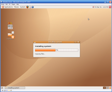
  • Enter telinit 5 and the X session will return, and voila, beatiful and without being scrambled. You should be able to click on Install and go on your merry way from here on out.
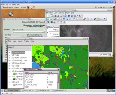
  • So now what? Where do I get those great Linux GIS goodies? Right from the get-go you should be able to go to Applications->Add/Remove and add in Quantum GIS (qgis).

  • For more apps, you can use the Synaptics Package Manager. Go into System->Administration->Synaptics Package Manager and add some of the repositories back in and hit "Reload" and then try searching. So far, I have been playing with desktop tools - GRASS, Thuban and QGIS. All quite painless to load using the package manager.

I am certainly no Linux guru, but was nonetheless able to get this environment up and running in Virtual PC in about an hour and a half. If you're mainly a Windows guy like me, you now no longer have much of an excuse to not try these out.

ESRI DevSummit 07 Blogosphere Wrapup

Posted by Dave Smith On 3/29/2007 04:04:00 PM 1 comments

Though I wasn't able to attend ESRI DevSummit 07, I did get some good feedback - my own people report on the continued push toward web-based GIS and server-based GIS and SOA, with SOAP, REST, JavaScript and AJAX APIs being made available, along with tremendous demand from the .NET developer community.

I also scoured the blogosphere and scavenged together a set of posts and resources - dig through these, as there are copious notes, slides and podcasts to be had.


In no particular order:


Very Spatial 3/28: Dev Summit Overview "VSTV Episode 12": http://veryspatial.com/?p=1486

Very Spatial 3/28: Daily Podcasts:
http://veryspatial.com/?p=1485

Very Spatial 3/26: Daily Podcast talking to DevSummit Attendees:
http://veryspatial.com/?p=1478

Very Spatial 3/24: Standards and Interoperability Podcast:
http://veryspatial.com/?p=1475

Very Spatial 3/23: ArcWeb Services Podcast:
http://veryspatial.com/?p=1473

Very Spatial 3/22: ESRI Support Team Podcast:
http://veryspatial.com/?p=1471

Very Spatial 3/22: Keynote Session Podcast:
http://veryspatial.com/?p=1468

Very Spatial 3/21: Keynote Comments:
http://veryspatial.com/?p=1466

Very Spatial 3/21: Gartner Keynote:
http://veryspatial.com/?p=1463

Very Spatial 3/20: Plenary Session Podcast:
http://veryspatial.com/?p=1462

Very Spatial 3/20: Plenary Part 2:
http://veryspatial.com/?p=1458

Very Spatial 3/20: Plenary Session:
http://veryspatial.com/?p=1457

Very Spatial 3/18: Preconference Podcast:
http://veryspatial.com/?p=1453


Steve's Little World 3/28: On participating in a VS podcast: http://thesteve0.wordpress.com/2007/03/28/if-you-want-to-hear-what-i-sound-like/

Steve's Little World 3/23: Final Day: http://thesteve0.wordpress.com/2007/03/23/final-day-and-still-in-palm-springs/

Steve's Little World 3/21: GeoDB Replication:
http://thesteve0.wordpress.com/2007/03/21/geodb-replication/

Steve's Little World 3/21: Web Service API to ArcGIS Server:
http://thesteve0.wordpress.com/2007/03/21/web-service-api-to-server/

Steve's Little World 3/21: Turbocharging GeoDB interactions:
http://thesteve0.wordpress.com/2007/03/21/turbocharging-geodb-interactions/

Steve's Little World 3/21: .NET and Java SIG:
http://thesteve0.wordpress.com/2007/03/21/net-sig/

Steve's Little World 3/21: The Gartner Talk:
http://myesri.blogspot.com/2007/03/update-from-dev-summit.html

Steve's Little World 3/20: Enterprise Applications with the GeoDB:
http://thesteve0.wordpress.com/2007/03/20/enterprise-applications-with-the-geodatabase/

Steve's Little World 3/20: .NET Mobile ADF:
http://thesteve0.wordpress.com/2007/03/20/net-mobile-adf/

Steve's Little World 3/20: .NET Engine Application Development:
http://thesteve0.wordpress.com/2007/03/20/net-engine-application-development/

Steve's Little World 3/20: First Night:
http://thesteve0.wordpress.com/2007/03/20/going-to-the-dev-summit-and-first-night/

Steve's Little World 3/20: Plenary Session:
http://thesteve0.wordpress.com/2007/03/20/plenary-session/


ESRI News Feed 3/15: ArcGIS Explorer Best Practices Podcast:
http://www.esri.com/news/podcasts/audio/speaker/devsummit07-mark-dara.mp3

ESRI News Feed 3/14: ArcGIS 9.2 3D Visualization Podcast:
http://www.esri.com/news/podcasts/audio/speaker/devsummit07-tam-nathan.mp3


Dot Without A Net 3/24: Dev Summit Day 3 Overview:
http://priour.wordpress.com/2007/03/24/dev-summit-final-day/

Dot Without A Net 3/22: Day 2:
http://priour.wordpress.com/2007/03/22/dev-summit-continues/

Dot Without A Net 3/22: Day 1:
http://priour.wordpress.com/2007/03/22/thoughts-on-dev-summit/


It Is What It Is 3/25: .NET versus Java:
http://www.palladiumconsulting.com/blog/sebastian/2007/03/who-was-at-esri-developer-summit-not.html

It Is What It Is 3/21: SQL API and Data Access:
http://www.palladiumconsulting.com/blog/sebastian/2007/03/esri-sde-stgeometry-and-re-unification.html

It Is What It Is: 3/21: It's not Crap Anymore:
http://www.palladiumconsulting.com/blog/sebastian/2007/03/esri-developer-summit-2007-its-not-crap.html


Rise and Shout 3/29: Developer Summit slides are now available on EDN:
http://myesri.blogspot.com/2007/03/dev-summit-slides-on-edn.html

Rise and Shout 3/26: Dev Summit Summary:
http://myesri.blogspot.com/2007/03/dev-summit-summary.html

Rise and Shout 3/21: Update:
http://myesri.blogspot.com/2007/03/update-from-dev-summit.html

Rise and Shout 3/20: Plenary Session:
http://myesri.blogspot.com/2007/03/arcgis-server-takes-stage-author-server.html

Rise and Shout 3/20: Dev Summit:
http://myesri.blogspot.com/2007/03/2nd-annual-esri-developer-summit.html

Rise and Shout 3/19: It's Time:
http://myesri.blogspot.com/2007/03/it-time.html


Dave Bouwman 3/22: Dev Summit Wrapup and SIG presentation:
http://blog.davebouwman.net/2007/03/23/DevSummitWrapup...

Dave Bouwman 3/20: Plenary Session:
http://blog.davebouwman.net/2007/03/20/DevSummitPlenarySession...

Dave Bouwman 3/14: Blogger Meetup:
http://blog.davebouwman.net/2007/03/15/DevSummitBloggerMeetup...


James Fee 3/25: Dev Summit ArcGIS Server Code Challenge Results:
http://www.spatiallyadjusted.com/2007/03/25/arcgis-server-code-challenge-results/

James Fee 3/21: .NET SIG:
http://www.spatiallyadjusted.com/2007/03/21/esri-dev-summit-net-sig/

James Fee 3/20: Dinner:
http://www.spatiallyadjusted.com/2007/03/20/esri-developer-summit-2007-dinner/


The Unofficial ArcBlog 3/25:
http://gis.typepad.com/blog/2007/03/esri_2007_devel.html


The Memory Leak 3/23: Defense SIG:
http://ambergis.wordpress.com/2007/03/23/esri-dev-summit-defense-sig/

The Memory Leak 3/21: ArcGIS GeoProcessing: http://ambergis.wordpress.com/2007/03/21/esri-dev-summit-ags-geoprocessing/

The Memory Leak 3/21: DevSummit Day 1: http://ambergis.wordpress.com/2007/03/21/esri-dev-summit-day-1/


The ArcPad Team: 3/28: On participating in a VS podcast: http://arcpadteam.blogspot.com/2007/03/1152-minutes-of-fame-its-very-spatial.html

The ArcPad Team: 3/22: Hello: http://arcpadteam.blogspot.com/2007/03/esri-developer-summit.html


Many thanks and kudos to all who shared with those of us who couldn't be there. I am certain I probably missed a few, but this provides an excellent roundup. Also, there is a post from Directions Magazine 3/22: Directions Magazine didn't attend, but nonetheless deserving special mention - Adena also pulled together an excellent collection of articles and items: http://www.directionsmag.com/article.php?article_id=2435&trv=1

Limnic Eruptions

Posted by Dave Smith On 3/24/2007 10:52:00 AM 1 comments

In examining Rwanda and Cameroon, I came across a number of articles discussing limnic eruptions - this is a natural event, where large amounts of dissolved and trapped gases in lakes suddenly and catastrophically become released, causing death to all living things within a substantial radius of the lake.

Typically this is due to volcanic vents, which release CO2, which becomes trapped in stratified layers deep in the lake. The trapped gases may remain undisturbed and in solution for long periods of time, and may continue to accumulate until an external event triggers instability, such as earthquake, landslide, rapid thermal change, or the like.

One particularly catastrophic and more well-known instance of this phenomenon is Lake Nyos, in Cameroon, where in August of 1986, an estimated 1,800 people and large amounts of livestock died due to suffocation. It is estimated that 1.6 million metric tons of CO2 were released in that instance. As CO2 is heavier than air, the gas fills valleys, and finds its way to low-lying areas in great concentration.

Fortunately this is a relatively uncommon occurrence - few lakes are known to have this type of supersaturation of gases and potential for catastrophic overturn. Lake Nyos is a fairly small lake, of 1.2 km2 - Lake Monoun is another small lake in Cameroon which has had similar catastropic incidents and loss of life in the past.

Another lake that is somewhat disconcerting is Lake Kivu, bordering Rwanda and the Democratic Republic of Congo - Lake Kivu is much larger - 2,700 km2, with a much larger population along its shores than these other lakes. It is unknown if Kivu is susceptible to similar massive overturn events, and Kivu has considerably greater depth that the two Cameroonian lakes, however it similarly displays the unusual supersaturation of gases characteristic of the other two lakes - and situated over the Rift Zone, and in proximity to Mount Nyiragongo, which last erupted in 2002- it is entirely possible that the same circumstances exist for continued contribution of CO2 and other gases.

In some instances, the lakes are being degassed, via pipes which seek to gradually release the concentrated gases, similar to slowly letting the fizz out of a soda can.
One such project is being conducted by the Lake Nyos and Monoun Degassing Project.

Rwanda

Posted by Dave Smith On 3/24/2007 12:29:00 AM 2 comments

Limited resources have caused some administrative delays in approaching the Engineers Without Borders projects - chances are now that we will not be able to pursue much until mid-June.

In the interim, I have been looking at some projects in Rwanda as well. Similar needs, water and wastewater, here set in Rwanda, near Lake Kivu and Gisenyi on the Congolese Border.

There are a number of Rwandan projects that EWB is currently looking at: EWB Rwanda Projects

Here, I have taken a similar approach, with SRTMs for elevations, to derive contours, hillshading, watersheds and other topography - I also imported NGA gazetteer data, and items from a few other disparate sources, such as WHO and others which were helpful for examining Cameroon. Am still waiting for access to a few remaining datasets and sources. Rwanda appears to have a ministry of the environment, which may have GIS data as well.

ESRI Developer Summit?

Posted by Dave Smith On 3/22/2007 08:56:00 PM 0 comments

No, I was not able to attend... Getting the occasional bits and pieces of information from the DevSummit.

For those folks who are attending, say hi to Xiuzhu Yang, a good friend of mine and very talented developer that I have been working with for the last year on EPA projects.

Another very talented guy that I cross paths with, also at the DevSummit this year is Vincent Zhuang from SAIC, author of Programming ASP.NET for ArcGIS Server.

HostGIS Linux

Posted by Dave Smith On 3/20/2007 02:13:00 PM 1 comments

I just discovered a great Linux distribution called HostGIS - it comes ready to run MapServer and a whole suite of other goodies, right out of the box.

I went to the HostGIS site, and within about 20 minutes, had downloaded it, loaded it up on MS VirtualPC, and had it up and running:


It comes complete with OpenLayers and TileCache from our friends at MetaCarta, MySQL, PostgreSQL, and a few other add-ons and goodies that I am not as familiar with, such as Map-Fu.

While I am usually spoiled with plenty of ESRI tools, this certainly provides a refreshing alternative for projects without an ESRI budget...

Cameroon GIS Data - and the benefits of technology

Posted by Dave Smith On 3/18/2007 11:12:00 AM 1 comments

I have gotten a few good responses regarding Cameroon GIS data for the Engineers Without Borders project thus far. Things like this make me consider how fortunate we are -

Here in the US, there are quite a few excellent datasets, rich with attributes, and with excellent positional accuracy.

Satellite technology and other approaches have made it much easier to get data for rural areas and those without the economic support for GIS that we enjoy here.

I can't imagine getting this far, this quickly trying to do any of this 10 or 15 years ago...

So far, I have obtained SRTM tiles with elevation data and quite a few other datasets, for protected areas, land use/land cover and other information... This is starting to come together. But please keep the suggestions and data coming...

In Search of Cameroon GIS Data

Posted by Dave Smith On 3/16/2007 08:50:00 PM 1 comments


I am currently working with Engineers Without Borders to look at a project in Cameroon, to provide a rural village with a viable potable water supply. To this end, I am looking for any pointers toward GIS data, aerial photos, elevation data, imagery and anything else of value in engineering design and environmental science that would help in design of water distribution, water conveyance via pipeline, wastewater treatment and the like. I'd like to be able to evaluate the big picture, with regard to potential opportunities and constraints to engineering design, ahead of a site visit to take place later in the year.

If you have access to data or good knowledge of GIS data in the region, Please contact me offline at dsmith (at) synergist-tech.com.


EPA Data and TerraIMS

Posted by Dave Smith On 3/12/2007 09:18:00 PM 0 comments

I don't always post about some of the things that we are working on, and perhaps I should do so more often.

I had some mixed feelings about recently seeing the Google Maps mashup that TerraIMS recently put up, showing EPA Superfund sites in proximity to a given address.
http://www.terraims.com/webservices/superfund.php


EPA has, for many years (in some instances, dating back to 1999), already had a number of community-oriented web mapping applications which deliver a great deal of information on EPA regulated sites, EPA cleanup activities, and so on - For example, one flagship of USEPA Office of Environmental Information is the venerable Window to My Environment - which, among other things, provides a great deal of information on EPA regulated facilities, watersheds, local and state resources, and the like at a community level. Window to My Environment currently gets well in excess of 50,000 hits per day.

Another excellent application which provides a lot of detailed information on environmental cleanup activity at a local level is the USEPA's Office of Solid Waste and Emergency Response (OSWER) Cleanups In My Community application.


These are just some of the web mapping projects that I have been involved in lately - there are actually several more EPA EnviroMapper applications available at the EnviroMapper StoreFront - and we are currently in the process of overhauling the core infrastructure of these, to migrate from legacy ASP/VBScript platforms to reusable component-based design, web services, and the ability to host some of these applications in an Oracle Portal environment, and integrating MetaCarta searches, among other things. We also have been doing some preliminary explorations in making EPA data available as KML for Google Earth, presenting some of our own Google Maps mashups (similar to TerraIMS), all of which are working wonderfully thus far. Unfortunately some of these enhancements are still in prototype, and others are only available on the EPA intranet.

So what of TerraIMS? Great work they did - but my concern isn't constrained, nor in any way specific to this particular mashup. The concern I have is with the description of the effort:

The U.S. Environmental Protection Agency recently released its National Priority list of Superfund Sites in XML format. We converted the XML data and integrated it with a database and then mashed things up a bit. Users enter an address and it is geocoded on the fly, enabling a distance query to be processed against the EPA data in the database. This mashup allows anyone to quickly and easily find the nearest Superfund Sites to their home address or a location of interest.

From this description, it sounds like they essentially have performed an extract of the EPA data, have massaged and processed it, and then do their mashup. The business case isn't tremendously compelling, as these maps and data are already long available, so it appears to be a mashup just for the sake of doing a mashup.

Fortunately Superfund data isn't tremendously volatile, however it nonetheless raises the question of other potential applications, of currency, completeness and accuracy of data utilized in mashups. Herein lies potential liability. If one uses a third-party mashup as a decision support tool, they would need to know to track back to the original source to ensure that the data they are viewing in the mashup is current, complete, and accurate...

Perilous Occupation

Posted by Dave Smith On 3/11/2007 10:55:00 AM 0 comments

Mike Berry found this interesting advertising insert card in a collection of advertising images from 1850-1920 housed at Duke University - these are from from the W. Duke Sons Tobacco Company. This series is from "50 Scenes of Perilous Occupations". The exhibit places Surveying between Circus Knife Throwing and Indian Scout...

St. Patrick's Parade

Posted by Dave Smith On 3/10/2007 09:58:00 PM 0 comments


Today, my town of Scranton PA celebrated its' annual St. Patrick's Day Parade. Scranton is blessed with one of the largest St. Pat's parades in the nation - this year, the line-up included 7,000 people, with 11 high school bands, 10 bagpipe bands and 13 other string and performing groups. Scranton has a heritage rich with Irish culture, with a St. Patricks Day Parade tradition going back to 1862.


Trimble VX Spatial Station

Posted by Dave Smith On 3/06/2007 01:41:00 PM 2 comments


I got a mailing today, probably several others of you did as well - announcing the Trimble VX Spatial Station. I had to chuckle, looking at the Matrix theme they put together for the ad campaign, considering the target as the typical pragmatic, grizzled, muddy-boots, over-50 demographic of surveyors... "wake up, Neo..."


I shouldn't tease Trimble - it is probably a lot more reflective of their own young and forward-looking demographic within Trimble, given their leadership and innovation in many other areas recently. Looks like a great product, and the next natural sequence of evolution as the Robotic/Reflectorless Total Station fuses with the 3D Scanner. It's the sort of thing that gets people like me thinking, what is the next phase of evolution.

For example, I was interested to see such things as fellow SDVOSB Penobscot Bay mounting scanners on robots, as well as another firm that we've worked with in the past, Spatial Integrated Systems / SIS, who has stripped-down scanners for confined spaces, such as on submarines.

So what's next in the far, or maybe not-so-far future? Perhaps a fusion of GPS and other technologies as well - a device you can carry in your pocket, which, when whipped out, establishes its geodetic position to centimeter level, scans the environment, and instantly constructs a georeferenced, 3-D spatial and temporal virtual environment, and stitches it in with other models already captured for a seamless database. Perhaps hyperspectral sensors, spectroscopy to determine the materials of the environment and more...

Imagine the design tools - you capture the environment, then don a headset which lets you mold and sculpt the environment in 3-D almost like it was wet clay. As you modify things, a number of models run simultaneously - finite elements analysis examining the structural details, other routines running to examine other impacts - stormwater and erosion, traffic, you name it.

Hey, a guy can dream, can't he?

Message In A Bottle

Posted by Dave Smith On 3/05/2007 12:41:00 PM 0 comments


Jerry Penry has just published an interesting article for American Surveyor magazine, discussing how ocean currents are mapped and tracked - one of these means being drift bottles.

NGS is one organization which has been using drift bottles since 1846. Some of the amazing travels of drift bottles are described in the article, and among the interesting exhibits in the article are a collection of bathtub toys accidentally lost from a ship from a cargo of tens of thousands, and set adrift, and another excellent exhibit in the article is a 1786 map by James Poupard, illustrating the Gulf Stream.

Coastline Erosion

Posted by Dave Smith On 3/05/2007 12:12:00 PM 0 comments

The Times Picayune has a good article discussing the dramatic, accelerated loss of coastline in Louisiana due to erosion:

It took the Mississippi River 6,000 years to build the La. coast. It took man 75 years to wash away a third of it. Experts agree we have 10 years or less to act before the loss becomes irreversible.


Also striking for me was the accompanying photo essay, which included photos of an NGS benchmark, which has long since lost integrity and become surrounded by water and ghost trees, where formerly there was shore...

Great sequence of photos from the Lunar Eclipse

Posted by Dave Smith On 3/05/2007 09:52:00 AM 0 comments

The Topografiando blog links to an excellent collage of photos posted to Flickr of the recent lunar eclipse, showing the sequence the earth's shadow as it passed across the moon. Our European neighbors were definitely more fortunate than us here, and many thanks to them for sharing their photos.

Jazz on a Sunday Afternoon

Posted by Dave Smith On 3/04/2007 10:00:00 AM 0 comments


I added a new thing to my blog sidebar - I downloaded a nifty gizmo from last.fm, called audioscrobbler. It lets me share what I'm listening to with others, by providing a web service that feeds current tracks being played in WinAmp, Windows Media Player or others.

Growing up, we always had eclectic tastes in music, and there was always some jazz in the house - Oscar Peterson, Dave Brubeck, and others... I have since acquired a taste for bop and funk-flavored jazz, Hammond B3 organ, sax, guitar, and other goodies - I enjoy Medeski, Martin and Wood, Hank Mobley, Cannonball Adderley, Wes Montgomery, Papa Grows Funk, Stanton Moore, Galactic, Art Blakey and the Jazz Messengers, John Scofield, Jimmy Smith, Jack McDuff, Joshua Redmon, Eddie Lockjaw Davis, and quite a few others...

I found that when I was studying, writing papers, and other kinds of intellectual pursuits, with many late nights listening to WRTI / Temple University Radio (especially B.P. with the G.M. and others...) and when trying to put myself in a groove to get things done, Jazz always fit the bill. Instrumental, my mind gets into the rhythm without being distracted by lyrics...

I have a collection of well over a thousand CDs, and also love being able to tune WRTI in when I am on the road, and another great thing is Pandora, which lets me create a customized radio station, designed after my own particular tastes... If you enjoy jazz, tune in...

Surveying on YouTube

Posted by Dave Smith On 3/04/2007 12:26:00 AM 1 comments

Great to see videos about surveying starting to show up on Youtube...


Kind of a quick and dirty introduction... well done, and kudos to the authors of this vid.

Never know what you might discover...

Posted by Dave Smith On 3/03/2007 10:14:00 PM 2 comments

I have to admit, I am a Google Earth junkie, and as a technocrat, I have multiple machines at my desk. When one is going to be sitting semi-idle or running background tasks for any period of time, I sometimes fire up Google Earth on it, zoom in to a low altitude, put a slight angle tilt on the view, and set it at a lazy drift over some semi-randomly selected countryside.

Periodically, I will stop and sit in amazement at some of the scenery. Ancient ruins, meteor craters, breathtaking landscapes... the lunar landscape of the Libyan desert, you name it. I also periodically check out the goodies that sites like Google Earth Hacks have, as well as some of the other sites that track not just Google Earth, but other sites featuring imagery.

Google Karten tracks Google Maps, and picked up one of the more amazing things I've seen in a while... A cruise missile, captured in-flight over Utah...

Lunar Eclipse?

Posted by Dave Smith On 3/03/2007 09:39:00 PM 0 comments


As a longtime amateur astronomer, I of course stepped outside to look for the moonrise, and the distinctive color of the lunar eclipse, but was only greeted by an overcast sky and a few flakes of snow. However, Ed Parsons was good enough to post a picture from his homestead of Teddington, UK (right)...

Truly magnificent, and many thanks to Ed for sharing. He was, of course a bit more fortunate than us in terms of timing:


Time to add GPS to the Swiss Army Knife?

Posted by Dave Smith On 3/03/2007 08:29:00 PM 0 comments


Associated Press is carrying the story about an accidental incursion of 170 Swiss infantry troops, as they strayed across an unmarked border into neighboring Liechtenstein. Fortunately these countries are generally on friendly terms, and in fact, according to the CIA World Factbook, Switzerland is responsible for the military defense of Liechtenstein; however these types of incidents illustrate how easy diplomatic snafus can happen...

It's also particularly ironic given the investments that the Swiss have made in quality geospatial products. Google Earth blog recently reported on getting imagery for the entire country of Switzerland at 50cm and many Swiss cities at 25cm, as well as improvements to the DTM models, with the entire country of Switzerland terrain at 10m resolution, and the Swiss Alps now high-res.

Search